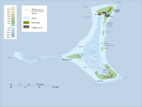
Yato (Pukapuka)
Qiyofa

Yato – Kuk orollaridagi Pukapuka atolli Wale orolidagi uchta qishloqdan biri. Yato – eng gʻarbiy qishloq va Motu Kotawa oroli[1] va Toka qum qirgʻogʻini tartibga soladi [2].
Niua maktabi qishloqda joylashgan.
Manbalar[tahrir | manbasini tahrirlash]
- ↑ „The motus of Pukapuka“. Cook Islands News (2012-yil 30-mart). Qaraldi: 2020-yil 18-avgust.
- ↑ Robert Alan Borofsky. Making History: the Creation of Traditional Knowledge on Pukapuka, a Polynesian Atoll. A dissertation submitted to the graduate division of the University of Hawaii in partial fulfilment of the requirements for the degree of Doctor of Philosophy in Anthropology. University of Hawaii, December 1982 — 37 bet.
10°51′12.56″S 165°50′49.96″W / 10.8534889°S 165.8472111°W
