
Fayl:Wfm area 51 landsat geocover 2000.jpg
Bu prevyuning hajmi: 475 × 599 piksel. Boshqa oʻlchamlari: 190 × 240 piksel | 381 × 480 piksel | 752 × 948 piksel.
Asl fayl (752 × 948 piksel, fayl hajmi: 383 KB, MIME tipi: image/jpeg)
| Taʼrif |
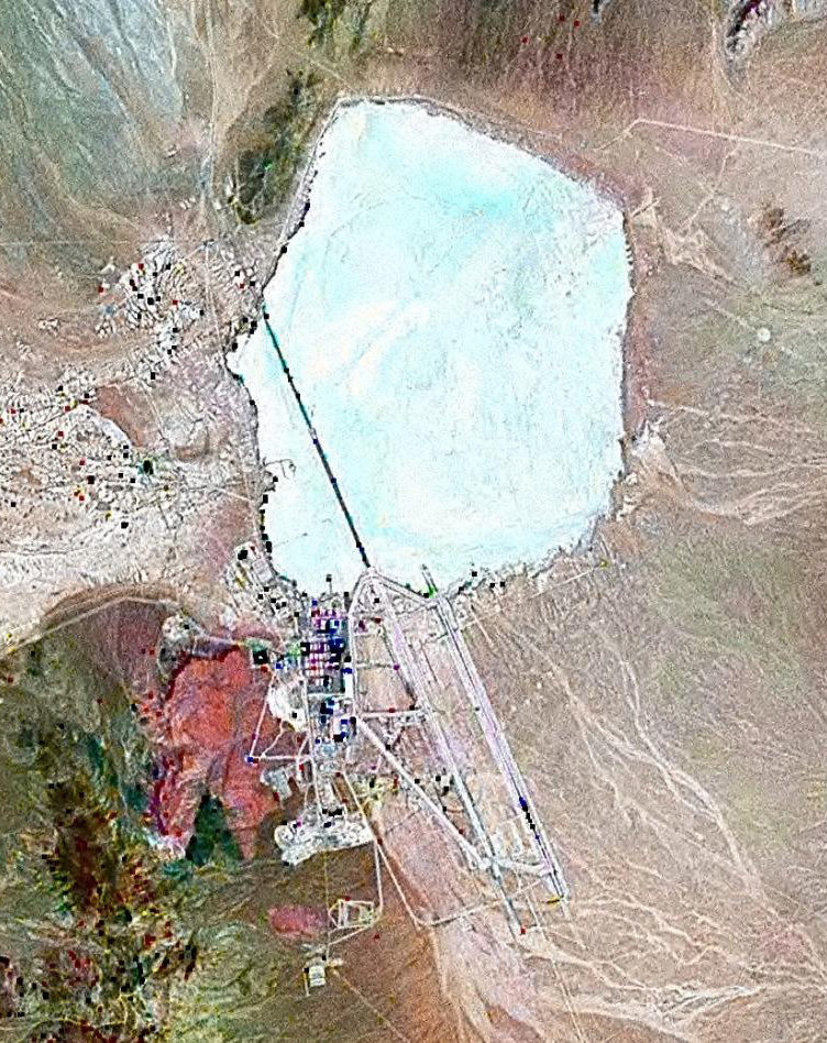
English: Landsat GeoCover 2000 pseudocolour imagery of Area 51 at Groom Lake, Nevada Test and Training Range, Nevada, USA
|
||||
| Sanasi | circa 2000 | ||||
| Manba | NASA Landsat | ||||
| Muallif | NASA | ||||
| Ruxsat (Bu faylning takror foydalanilishi) |
|

Fayl tarixi
Faylning biror paytdagi holatini koʻrish uchun tegishli sana/vaqtga bosingiz.
| Sana/Vaqt | Miniatura | Oʻlchamlari | Foydalanuvchi | Izoh | |
|---|---|---|---|---|---|
| joriy | 12:42, 18-Fevral 2010 | | 752 × 948 (383 KB) | Finlay McWalter | rv, that's not a landsat image; it looks very much like a copyright GeoEye/Google Earth image, which is inelligible for use on Commons. If you diagree, upload the image under another name, don't contaminate this one with false information |
| 11:05, 7-Fevral 2010 |  | 456 × 617 (45 KB) | Vajotwo | Best quality | |
| 12:51, 16-Iyul 2006 |  | 752 × 948 (383 KB) | Finlay McWalter | {{Information |Description=Landsat geocover 2000 pseudocolour imagery of Area 51 at Groom Lake, Nevada, USA |Source=NASA Landsat |Date=around 2000 |Author=NASA |Permission= {{PD-WorldWind}} |other_versions= }} Category:Area 51 |
Fayllarga ishoratlar
Bu faylga quyidagi sahifa bogʻlangan:
Faylning global foydalanilishi
Ushbu fayl quyidagi vikilarda ishlatilyapti:
- ar.wikipedia.org loyihasida foydalanilishi
- az.wikipedia.org loyihasida foydalanilishi
- be.wikipedia.org loyihasida foydalanilishi
- bg.wikipedia.org loyihasida foydalanilishi
- bn.wikipedia.org loyihasida foydalanilishi
- cs.wikipedia.org loyihasida foydalanilishi
- cy.wikipedia.org loyihasida foydalanilishi
- el.wikipedia.org loyihasida foydalanilishi
- en.wikipedia.org loyihasida foydalanilishi
- es.wikipedia.org loyihasida foydalanilishi
- fi.wikipedia.org loyihasida foydalanilishi
- fr.wikipedia.org loyihasida foydalanilishi
- Zone 51
- Wikipédia:Le Bistro/14 février 2009
- Area 51 (jeu vidéo, 2005)
- Wikipédia:Wikimag/2019/28/Rapport de trafic
- Wikipédia:Wikimag/2019/29/Rapport de trafic
- Wikipédia:Wikimag/2019/29
- Wikipédia:Wikimag/2019/30/Rapport de trafic
- Wikipédia:Wikimag/2019/31/Rapport de trafic
- Wikipédia:Wikimag/2019/38
- Wikipédia:Wikimag/2019/39/Rapport de trafic
- gu.wikipedia.org loyihasida foydalanilishi
- he.wikipedia.org loyihasida foydalanilishi
- hi.wikipedia.org loyihasida foydalanilishi
- hr.wikipedia.org loyihasida foydalanilishi
- hu.wikipedia.org loyihasida foydalanilishi
- hy.wikipedia.org loyihasida foydalanilishi
- id.wikipedia.org loyihasida foydalanilishi
- it.wikipedia.org loyihasida foydalanilishi
- kk.wikipedia.org loyihasida foydalanilishi
- kn.wikipedia.org loyihasida foydalanilishi
- mk.wikipedia.org loyihasida foydalanilishi
- my.wikipedia.org loyihasida foydalanilishi
- pnb.wikipedia.org loyihasida foydalanilishi
- ro.wikipedia.org loyihasida foydalanilishi
- ru.wikipedia.org loyihasida foydalanilishi
- sh.wikipedia.org loyihasida foydalanilishi
- si.wikipedia.org loyihasida foydalanilishi
Ushbu faylni koʻproq global foydalanishdan koʻring.