
Fayl:Mapofthehotaks1728.png

Bu prevyuning hajmi: 800 × 598 piksel. Boshqa oʻlchamlari: 320 × 239 piksel | 640 × 478 piksel | 1 024 × 765 piksel | 1 280 × 957 piksel | 2 560 × 1 914 piksel | 3 711 × 2 774 piksel.
Asl fayl (3 711 × 2 774 piksel, fayl hajmi: 284 KB, MIME tipi: image/png)

|
This map image could be re-created using vector graphics as an SVG file. This has several advantages; see Commons:Media for cleanup for more information. If an SVG form of this image is available, please upload it and afterwards replace this template with
{{vector version available|new image name}}.
It is recommended to name the SVG file “Mapofthehotaks1728.svg”—then the template Vector version available (or Vva) does not need the new image name parameter. |
Qisqa izoh
| Taʼrif |
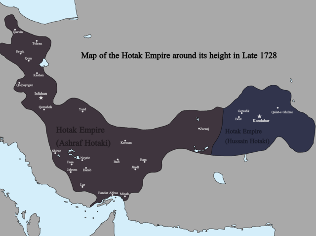
English: Map of the Hotak Empire around late 1728. Sources consulted in the making of this map include:
The Fall of the Safavi Dynasty and the Afghan Occupation of Persia by Laurence Lockhart The Afghan Occupation of Safavid Persia 1721-1729 by Willem Floor Articles from Encyclopedia Iranica History of the Wars 1721-1738 by Abraham of Erevan and translated by George A. Bournoutian The Chronicles of a Traveller: Or, A History of the Afghan Wars with Persia by Tadeusz Judas Krusiński |
| Sanasi | |
| Manba | Oʻzimning ishim |
| Muallif | Kailanmapper |
Litsenziyalash
I, the copyright holder of this work, hereby publish it under the following license:
This file is licensed under the Creative Commons Attribution-Share Alike 4.0 International license.
- Siz erkinsiz:
- ulashishga – ishlanmani nusxalash, tarqatish va uzatish
- remiks qilishga – ishni moslashtirishga
- Quyidagi shartlar asosida:
- atribut – Siz tegishli litsenziyaga havolani taqdim etishingiz va oʻzgartirishlar kiritilganligini koʻrsatishingiz kerak. Siz buni har qanday oqilona yoʻl bilan qilishingiz mumkin, lekin litsenziar Sizni yoki Sizning foydalanishingizni ma'qullashini taklif qiladigan tarzda emas.
- bir xil ulashish – Agar Siz materialni remiks qilsangiz, oʻzgartirsangiz yoki unga asoslansangiz, oʻz hissalaringizni asl nusxadagi kabi bir xil yoki mos litsenziya ostida tarqatishingiz kerak.
Fayl tarixi
Faylning biror paytdagi holatini koʻrish uchun tegishli sana/vaqtga bosingiz.
| Sana/Vaqt | Miniatura | Oʻlchamlari | Foydalanuvchi | Izoh | |
|---|---|---|---|---|---|
| joriy | 01:31, 13-Iyul 2021 | | 3 711 × 2 774 (284 KB) | Kailanmapper | First map incorrectly had Golpayegan labeled as Qom |
| 21:45, 12-Iyul 2021 |  | 3 711 × 2 774 (280 KB) | Kailanmapper | Uploaded own work with UploadWizard |
Fayllarga ishoratlar
Bu faylga quyidagi sahifa bogʻlangan:
Faylning global foydalanilishi
Ushbu fayl quyidagi vikilarda ishlatilyapti:
- bn.wikipedia.org loyihasida foydalanilishi
- de.wikipedia.org loyihasida foydalanilishi
- en.wikipedia.org loyihasida foydalanilishi
- fr.wikipedia.org loyihasida foydalanilishi
- hy.wikipedia.org loyihasida foydalanilishi
- ko.wikipedia.org loyihasida foydalanilishi
- mnw.wikipedia.org loyihasida foydalanilishi
- pl.wikipedia.org loyihasida foydalanilishi
- tr.wikipedia.org loyihasida foydalanilishi