
Fayl:Mackenzie river enters Beaufort sea.jpg

Asl fayl (9 000 × 7 500 piksel, fayl hajmi: 64 MB, MIME tipi: image/jpeg)
Qisqa izoh
| Taʼrif |
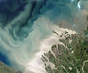
English: The Mackenzie River is the leading source of freshwater flowing into the Arctic Ocean. It's also a leading source of sediment flowing into that basin.
The Operational Land Imager (OLI) on the Landsat 8 satellite acquired this image of the Mackenzie Delta on July 19, 2017. At the time, the Beaufort Sea was colored with milky, tan brush strokes of sediment in various levels of dispersal after pouring out of the river. The Mackenzie is the largest and longest northward-flowing river in North America, and the second largest on the continent (after the Mississippi). The watershed drains a huge, but mostly unsettled portion of Canada; population density along the 4,200 kilometer (2,600 mile) river is just 1 person per square kilometer. About 7 percent of the fresh water that flows into the Arctic Ocean each year comes out the Mackenzie and its delta, and much of that comes in large pulses in June and July after the freshet—when inland ice and snow melts and floods the river. The spring flood carries with it tremendous amounts of dissolved organic material and sediment. More info & refs at source. |
| Sanasi | acquired July 19, 2017 |
| Manba | https://earthobservatory.nasa.gov/IOTD/view.php?id=90703&src=eoa-iotd |
| Muallif | NASA Earth Observatory images by Jesse Allen, using Landsat data from the U.S. Geological Survey |
Litsenziyalash
| This file is in the public domain in the United States because it was solely created by NASA. NASA copyright policy states that "NASA material is not protected by copyright unless noted". (See Template:PD-USGov, NASA copyright policy page or JPL Image Use Policy.) | ||
 |
Warnings:
|
Fayl tarixi
Faylning biror paytdagi holatini koʻrish uchun tegishli sana/vaqtga bosingiz.
| Sana/Vaqt | Miniatura | Oʻlchamlari | Foydalanuvchi | Izoh | |
|---|---|---|---|---|---|
| joriy | 07:28, 7-Yanvar 2021 | | 9 000 × 7 500 (64 MB) | StellarHalo | higher resolution |
| 05:25, 9-Avgust 2017 |  | 720 × 600 (276 KB) | Tillman | {{Information |Description ={{en|1=The Mackenzie River is the leading source of freshwater flowing into the Arctic Ocean. It's also a leading source of sediment flowing into that basin. The Operational Land Imager (OLI) on the Landsat 8 satellite a... |
Fayllarga ishoratlar
Bu faylga quyidagi sahifa bogʻlangan:
Faylning global foydalanilishi
Ushbu fayl quyidagi vikilarda ishlatilyapti:
- de.wikipedia.org loyihasida foydalanilishi
- en.wikipedia.org loyihasida foydalanilishi
- sl.wikipedia.org loyihasida foydalanilishi