
Fayl:Japan Relief Map of Land and Seabed.png
Bu prevyuning hajmi: 727 × 599 piksel. Boshqa oʻlchamlari: 291 × 240 piksel | 582 × 480 piksel | 932 × 768 piksel | 1 242 × 1 024 piksel | 2 117 × 1 745 piksel.
Asl fayl (2 117 × 1 745 piksel, fayl hajmi: 7,47 MB, MIME tipi: image/png)
Qisqa izoh
| Taʼrif |
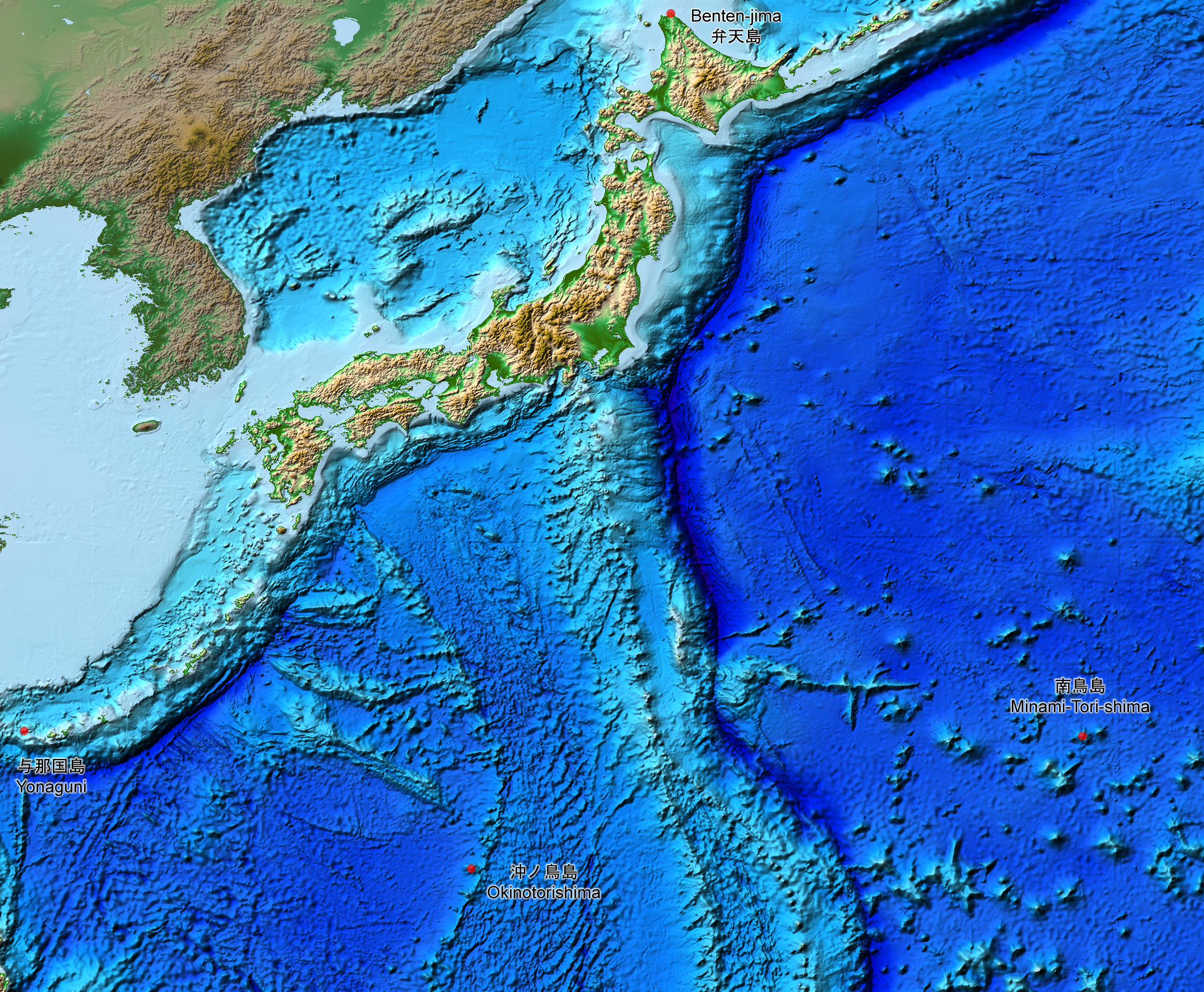
English: This is a relief map of the land and the seabed of Japan. It shows the surface and underwater terrain of the Japanese archipelago. It includes all the Japanese islands such as Minami-Tori-Shima, Benten-jima, Okinotorishima and Yonaguni.
日本語: 日本近海海底地形図と日本列島。 |
| Sanasi | |
| Manba | ETOPO1, Global Relief Model, https://www.ngdc.noaa.gov/mgg/global/global.html |
| Muallif | NASA, National Geophysical Data Center, NOAA |
Litsenziyalash
| This file is in the public domain in the United States because it was solely created by NASA. NASA copyright policy states that "NASA material is not protected by copyright unless noted". (See Template:PD-USGov, NASA copyright policy page or JPL Image Use Policy.) | ||
 |
Warnings:
|
Fayl tarixi
Faylning biror paytdagi holatini koʻrish uchun tegishli sana/vaqtga bosingiz.
| Sana/Vaqt | Miniatura | Oʻlchamlari | Foydalanuvchi | Izoh | |
|---|---|---|---|---|---|
| joriy | 15:07, 5-avgust 2019 | | 2 117 × 1 745 (7,47 MB) | Artanisen | The continent geography is darker to highlight the Japanese archipelago. |
| 06:29, 22-iyul 2019 |  | 2 117 × 1 745 (7,54 MB) | Artanisen | User created page with UploadWizard |
Fayllarga ishoratlar
Bu faylga quyidagi sahifa bogʻlangan:
Faylning global foydalanilishi
Ushbu fayl quyidagi vikilarda ishlatilyapti:
- ar.wikipedia.org loyihasida foydalanilishi
- ast.wikipedia.org loyihasida foydalanilishi
- be.wikipedia.org loyihasida foydalanilishi
- ca.wikipedia.org loyihasida foydalanilishi
- de.wikipedia.org loyihasida foydalanilishi
- en.wikipedia.org loyihasida foydalanilishi
- es.wikipedia.org loyihasida foydalanilishi
- fr.wikipedia.org loyihasida foydalanilishi
- id.wikipedia.org loyihasida foydalanilishi
- it.wikipedia.org loyihasida foydalanilishi
- ja.wikipedia.org loyihasida foydalanilishi
- min.wikipedia.org loyihasida foydalanilishi
- pnb.wikipedia.org loyihasida foydalanilishi
- pt.wikipedia.org loyihasida foydalanilishi
- ru.wikipedia.org loyihasida foydalanilishi
- sl.wikipedia.org loyihasida foydalanilishi
- sr.wikipedia.org loyihasida foydalanilishi
- tl.wikipedia.org loyihasida foydalanilishi
- uk.wikipedia.org loyihasida foydalanilishi
- vi.wikipedia.org loyihasida foydalanilishi
- www.wikidata.org loyihasida foydalanilishi
- zh-min-nan.wikipedia.org loyihasida foydalanilishi
- zh.wikipedia.org loyihasida foydalanilishi