Vikipediya, ochiq ensiklopediya
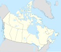
Asl fayl (SVG fayl, asl oʻlchamlari 1 114 × 942 piksel, fayl hajmi: 365 KB)
Ushbu fayl Vikiomborga yuklangan boʻlib, boshqa loyihalarda ham qoʻllanilishi mumkin.
Uning tavsif sahifasidan olingan maʼlumot quyida keltirilgan.
Qisqa izoh Map Info
Properties
Projection:
Lambert conformal conic
Datum:
WGS84
Central Meridian:
95.000000°W
Latitude of Origin:
60.000000°N
Standard Parallel #1:
49.000000°N
Standard Parallel #2:
77.000000°N
Mathematics (conversion from latitude and longitude to image coordinate)
x (%)=
201.7818903*(((tan(pi*(90-$1)/360))*(((1+0.08181919084*sin(pi*$1/180))/(1-0.08181919084*sin(pi*$1/180)))^0.04090959542))^0.9007900864)*sin(0.01572175288*($2+95))+43.98563734
y (%)=
238.6252927*(((tan(pi*(90-$1)/360))*(((1+0.08181919084*sin(pi*$1/180))/(1-0.08181919084*sin(pi*$1/180)))^0.04090959542))^0.9007900864)*cos(0.01572175288*($2+95))-15.81495465
$1:
latitude in degrees (positive for all locations in Canada).
$2:
longitude in degrees (negative for all locations in Canada).
x (%):
x coordinate expressed as percentage of image width (measured from left edge).
y (%):
y coordinate expressed as percentage of image height (measured from top edge).
POIs
x (px)
y (px)
x (%)
y (%)
Latitude
Longitude
Top Left Corner:
0.000
0.000
0.00
0.00
68.220310°N
176.138684°W
Top Right Corner:
1114.000
0.000
100.00
0.00
62.238635°N
9.994317°W
Bottom Right Corner:
1114.000
942.000
100.00
100.00
34.831244°N
61.953430°W
Bottom Left Corner:
0.000
942.000
0.00
100.00
37.392537°N
121.850536°W
Centre:
557.000
471.000
50.00
50.00
63.068962°N
88.152750°W
Origin:
490.000
541.000
43.99
57.43
60.000000°N
95.000000°W
North Pole:
490.000
-148.977
43.99
-15.81
90.000000°N
⸻
Thechàl Dhâl:
67.523
368.241
6.06
39.09
61.022873°N
138.564925°W
Litsenziyalash I, the copyright holder of this work, hereby publish it under the following license:
Siz erkinsiz:
ulashishga – ishlanmani nusxalash, tarqatish va uzatishremiks qilishga – ishni moslashtirishga
Quyidagi shartlar asosida:
atribut – Siz tegishli litsenziyaga havolani taqdim etishingiz va oʻzgartirishlar kiritilganligini koʻrsatishingiz kerak. Siz buni har qanday oqilona yoʻl bilan qilishingiz mumkin, lekin litsenziar Sizni yoki Sizning foydalanishingizni ma'qullashini taklif qiladigan tarzda emas.bir xil ulashish – Agar Siz materialni remiks qilsangiz, oʻzgartirsangiz yoki unga asoslansangiz, oʻz hissalaringizni asl nusxadagi kabi bir xil yoki mos litsenziya ostida tarqatishingiz kerak. https://creativecommons.org/licenses/by-sa/4.0 CC BY-SA 4.0 Creative Commons Attribution-Share Alike 4.0 true true oʻzbekcha / ўзбекча Add a one-line explanation of what this file represents
fransuzcha carte politique du Canada
kajun fransuz Location map of Canada
Fayl tarixi
Fayllarga ishoratlar
Bu faylga quyidagi 6 sahifalar bogʻlangan:
Faylning global foydalanilishi
Ushbu fayl quyidagi vikilarda ishlatilyapti:
af.wikipedia.org loyihasida foydalanilishi
azb.wikipedia.org loyihasida foydalanilishi
ban.wikipedia.org loyihasida foydalanilishi
ca.wikipedia.org loyihasida foydalanilishi
en.wikipedia.org loyihasida foydalanilishi
Ushbu faylni koʻproq global foydalanishdan koʻring.
Bu fayl qoʻshimcha maʼlumotlarni oʻz ichiga oladi, ehtimol uni tuzish yoxud raqamlashtirish uchun raqamli kamera yoki skanerdan foydalanilgan.
Agar fayl asl holatidan oʻzgartirilgan boʻlsa, baʼzi tafsilotlar oʻzgartirilgan faylni toʻliq aks ettirmasligi mumkin.


