
Fayl:Babylone 1.PNG

Bu prevyuning hajmi: 800 × 559 piksel. Boshqa oʻlchamlari: 320 × 224 piksel | 640 × 447 piksel | 982 × 686 piksel.
Asl fayl (982 × 686 piksel, fayl hajmi: 960 KB, MIME tipi: image/png)
| Taʼrif |
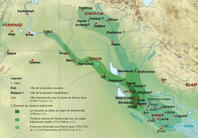
English: Map of the kingdom of the First Dynasty of Babylon from the beginning of the reign of Hammurabi (1792-1750 BC according to middle chronology) to the fall of Babylon in 1595 BC. The maximal extension of the kingdom under the reigns of Hammrabi and his son Samsu-iluna includes cities that have been taken by those kings, but probably dominated at best a few years, like Tuttul, Nineveh and Shekhna. The domination of Terqa by the successors of Samsu-iluna is probable because of some of them appear in the name years of tablets excavated there (Ammi-saduqa, Samsu-ditana). Français : Carte du royaume de la Première dynastie de Babylone depuis le début du règne de Hammurabi (1792-1750 av. J.-C. selon la chronologie moyenne) jusqu'à la chute de Babylone en 1595. L'extension maximale du royaume sous les règnes de Hammurabi et Samsu-iluna inclut des villes qui ont été dominées au mieux quelques années comme Tuttul, Ninive ou Shekhna. La domination de Terqa sous les successeurs de Samsu-iluna est probable du fait de l'utilisation du nom de certains d'entre eux pour dater des tablettes exhumées sur ce site (Ammi-saduqa, Samsu-ditana). |
| Sanasi | (UTC) |
| Manba | |
| Muallif |
|
| Other versions |
 |
| This is a retouched picture, which means that it has been digitally altered from its original version. Modifications: Extension du royaume, villes, légende.. The original can be viewed here: Near East topographic map-blank.svg:
|
I, the copyright holder of this work, hereby publish it under the following licenses:
This file is licensed under the Creative Commons Attribution-Share Alike 3.0 Unported, 2.5 Generic, 2.0 Generic and 1.0 Generic license.
- Siz erkinsiz:
- ulashishga – ishlanmani nusxalash, tarqatish va uzatish
- remiks qilishga – ishni moslashtirishga
- Quyidagi shartlar asosida:
- atribut – Siz tegishli litsenziyaga havolani taqdim etishingiz va oʻzgartirishlar kiritilganligini koʻrsatishingiz kerak. Siz buni har qanday oqilona yoʻl bilan qilishingiz mumkin, lekin litsenziar Sizni yoki Sizning foydalanishingizni ma'qullashini taklif qiladigan tarzda emas.
- bir xil ulashish – Agar Siz materialni remiks qilsangiz, oʻzgartirsangiz yoki unga asoslansangiz, oʻz hissalaringizni asl nusxadagi kabi bir xil yoki mos litsenziya ostida tarqatishingiz kerak.

|
Ushbu hujjatdan nusxa ko‘chirish, tarqatish va/yoki o‘zgartirish uchun GNU Erkin guvohnoma litsenziyasi (GNU Free Documentation License), 1.2 va har qanday keyingi versiyalar shartlariga muvofiq ruxsat berilgan yoki Ochiq kodli dasturlar jamiyati (Free Software Foundation) tomonidan chop etilgan; oʻzgarmas boʻlimlarsiz, oldingi muqova matnlari va orqa muqova matnlarisiz. Litsenziya nusxasi GNU Erkin guvohnoma litsenziyasi (GNU Free Documentation License) boʻlimiga kiritilgan. |
Siz oʻzingiz xohlagan litsenziyani tanlashingiz mumkin.
Original upload log
This image is a derivative work of the following images:
- File:Near_East_topographic_map-blank.svg licensed with Cc-by-sa-3.0,2.5,2.0,1.0, GFDL
- 2009-08-18T18:31:37Z Sémhur 2425x1581 (2442670 Bytes) 3 - New try
- 2009-08-17T15:39:22Z Sémhur 2425x1581 (1815374 Bytes) 2 - With the background...
- 2009-08-17T15:37:36Z Sémhur 2425x1581 (2836 Bytes) {{Information |Description={{en|1=Blank physical map of the [[:en:Near East|Near East]]}} {{fr|1=Carte physique vierge du [[:fr:Proche-Orient|Proche-Orient]].}} |Source={{own}} |Author=[[User:Sémhur|Sémhur]] |Date=2008-08-1
Uploaded with derivativeFX
Fayl tarixi
Faylning biror paytdagi holatini koʻrish uchun tegishli sana/vaqtga bosingiz.
| Sana/Vaqt | Miniatura | Oʻlchamlari | Foydalanuvchi | Izoh | |
|---|---|---|---|---|---|
| joriy | 16:16, 29-Sentyabr 2010 | | 982 × 686 (960 KB) | Zunkir | {{Information |Description={{en|1=Map of the kigdom of the First Dynasty of Babylon from the beginning of the reign of Hammurabi (1792-1750 BC according to middle chronology) to the fall of Babylon in 1595 BC. The maximal extension of the kigdom under the |
Fayllarga ishoratlar
Bu faylga quyidagi sahifa bogʻlangan:
Faylning global foydalanilishi
Ushbu fayl quyidagi vikilarda ishlatilyapti:
- am.wikipedia.org loyihasida foydalanilishi
- ar.wikipedia.org loyihasida foydalanilishi
- arz.wikipedia.org loyihasida foydalanilishi
- bn.wikipedia.org loyihasida foydalanilishi
- ca.wikipedia.org loyihasida foydalanilishi
- ceb.wikipedia.org loyihasida foydalanilishi
- cs.wikipedia.org loyihasida foydalanilishi
- de.wikipedia.org loyihasida foydalanilishi
- en.wikipedia.org loyihasida foydalanilishi
- fa.wikipedia.org loyihasida foydalanilishi
- fi.wikipedia.org loyihasida foydalanilishi
- fr.wikipedia.org loyihasida foydalanilishi
- Antiquité
- XVIIIe siècle av. J.-C.
- Ninive
- Hammurabi
- Histoire de l'Irak
- Code de Hammurabi
- Samsu-iluna
- Liste des souverains de Babylone
- Histoire de la Mésopotamie
- Babylone (civilisation)
- Proche-Orient ancien
- Utilisateur:Zunkir/POA autres
- Utilisateur:Zunkir/cartothèque
- Première dynastie de Babylone
- Littérature irakienne
- id.wikipedia.org loyihasida foydalanilishi
- incubator.wikimedia.org loyihasida foydalanilishi
- ja.wikipedia.org loyihasida foydalanilishi
- ko.wikipedia.org loyihasida foydalanilishi
Ushbu faylni koʻproq global foydalanishdan koʻring.