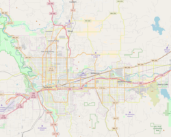
Modul:Location map/data/United States Greater Spokane
| name | Greater Spokane area | |||
|---|---|---|---|---|
| border coordinates | ||||
| 47.8281 | ||||
| -117.5602 | ←↕→ | -117.061 | ||
| 47.5598 | ||||
| map center | 47°41′38″N 117°18′38″W / 47.69395°N 117.3106°W G O | |||
| image | Location Map United States Greater Spokane.png
| |||

| ||||
Modul:Location map/data/United States Greater Spokane joylashuv xaritasi taʼrifi boʻlib, an equirectangular projection Greater Spokane areadagi markerlar va yorliqlarni joylashtirish uchun foydalaniladi. :Modul:Location map/data/United States Greater Spokane|1|3}}|ism}}]]}}}. Markerlar standart xaritada yoki shunga o'xshash xarita tasvirida kenglik va uzunlik koordinatalari bo'yicha joylashtiriladi.
Qoʻllanilishi
Ushbu ta'riflar parametr bilan chaqirilganda quyidagi andozalar tomonidan qo'llaniladi „United States Greater Spokane“:
{{Location map | United States Greater Spokane | …}}{{Location map many | United States Greater Spokane | …}}{{Location map+ | United States Greater Spokane | …}}{{Location map~ | United States Greater Spokane | …}}
Xarita tavsifi
name = Greater Spokane area- Standart xarita sarlavhasida foydalanilgan ism
image = Location Map United States Greater Spokane.png- Standart xarita tasviri, “Rasm:” yoki “Fayl:”siz
top = 47.8281- Latitude at top edge of map, in decimal degrees
bottom = 47.5598- Latitude at bottom edge of map, in decimal degrees
left = -117.5602- Longitude at left edge of map, in decimal degrees
right = -117.061- Longitude at right edge of map, in decimal degrees
Precision
Longitude: from West to East this map definition covers Expression error: Unrecognized punctuation character " ". degrees.
- At an image width of 200 pixels, that is Expression error: Unrecognized punctuation character " ". degrees per pixel.
- At an image width of 1000 pixels, that is Expression error: Unrecognized punctuation character " ". degrees per pixel.
Latitude: from North to South this map definition covers Expression error: Unrecognized punctuation character " ". degrees.
- At an image height of 200 pixels, that is Expression error: Unrecognized punctuation character " ". degrees per pixel.
- At an image height of 1000 pixels, that is Expression error: Unrecognized punctuation character " ". degrees per pixel.
Xaritalar joylashuvi andozalariga misollar
Location map, using default map (image)
{{Location map | United States Greater Spokane
 | width   = 250
 | lat_deg = 47.652
 | lon_deg = -117.42
 | label   = [[Lewis and Clark High School]]
}}
Location map many
{{Location map many | United States Greater Spokane
 | width    = 250
 | caption  = Two locations in the greater Spokane area
 | lat1_deg = 47.652
 | lon1_deg = -117.42
 | label1   = [[Lewis and Clark High School|L&C]]
 | lat2_deg = 47.705
 | lon2_deg = -117.483
 | label2   = [[Joe Albi Stadium]]
 | mark2    = Stadium - The Noun Project.svg
 | mark2size= 16
 | position2= bottom
}}
Location map+
{{Location map+ | United States Greater Spokane
| width   = 400
| caption = Many locations in the greater Spokane area
| places  =
  {{Location map~ | United States Greater Spokane
   | lat_deg = 47.652
   | lon_deg = -117.42
   | label   = [[Lewis and Clark High School|L&C]]
   | position=
  }}
  {{Location map~ | United States Greater Spokane
   | lat_deg = 47.61975
   | lon_deg = -117.365861
   | label   = [[Joel E. Ferris High School|Ferris]]
   | position=
  }}
  {{Location map~ | United States Greater Spokane
   | lat_deg = 47.685833
   | lon_deg = -117.391944
   | label   = [[Gonzaga Preparatory School|G-Prep]]
   | position=
  }}
  {{Location map~ | United States Greater Spokane
   | lat_deg = 47.649444
   | lon_deg = -117.193611
   | label   = [[Central Valley High School (Washington)|CV]]
   | position=
  }}
  {{Location map~ | United States Greater Spokane
   | lat_deg = 47.77
   | lon_deg = -117.414722
   | label   = [[Mead High School|Mead]]
   | position=
  }}
  {{Location map~ | United States Greater Spokane
   | lat_deg = 47.627222
   | lon_deg = -117.236667
   | label   = [[University High School (Spokane Valley)|U-Hi]]
   | position=
  }}
  {{Location map~ | United States Greater Spokane
   | lat_deg = 47.788611
   | lon_deg = -117.322778
   | label   = [[Mt. Spokane High School|Mt. Spokane]]
   | mark    = Blue pog.svg
   | position=
  }}
  {{Location map~ | United States Greater Spokane
   | lat_deg = 47.671639
   | lon_deg = -117.419028
   | label   = [[North Central High School|NC]]
   | mark    = Blue pog.svg
   | position=
  }}
  {{Location map~ | United States Greater Spokane
   | lat_deg = 47.700
   | lon_deg = -117.386
   | label   = [[John R. Rogers High School|Rogers]]
   | mark    = Blue pog.svg
   | position=
  }}
  {{Location map~ | United States Greater Spokane
   | lat_deg = 47.698
   | lon_deg = -117.437
   | label   = [[Shadle Park High School|Shadle<br/>Park<br/>↓]]
   | mark    = Blue pog.svg
   | position= top
  }}
  {{Location map~ | United States Greater Spokane
   | lat_deg = 47.705
   | lon_deg = -117.483
   | label   = [[Joe Albi Stadium|Joe Albi]]
   | mark    = Stadium - The Noun Project.svg
   | marksize= 16
   | position= bottom
  }}
}}
Yana qarang
Xaritalar joylashuvi andozalari
- Template:Location map, to display one mark and label using latitude and longitude
- Template:Location map many, to display up to nine marks and labels
- Template:Location map+, to display an unlimited number of marks and labels

