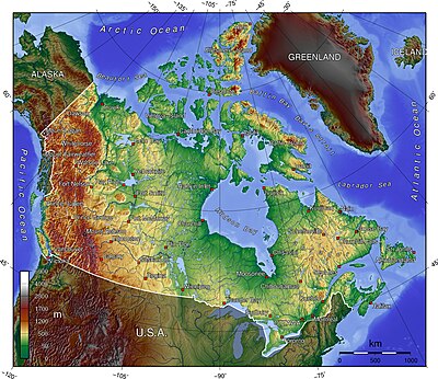
Modul:Location map/data/CanadaTerrain
| name | Canada | ||
|---|---|---|---|
| x | 51.3688770752693 - 2.08993734501698*($1 - 89.1948328371273)*sin(0.0146738856952723*($2 - ($2 > 0)*360 + 88.6496582505060)) | ||
| y | -6.11618556585059 - 2.08993734501698*($1 - 89.1948328371273)*cos(0.0146738856952723*($2 - ($2 > 0)*360 + 88.6496582505060)) | ||
| image | Canada topo.jpg
| ||

| |||
Modul:Location map/data/CanadaTerrain joylashuv xaritasi taʼrifi boʻlib, an equirectangular projection Canadadagi markerlar va yorliqlarni joylashtirish uchun foydalaniladi. :Modul:Location map/data/CanadaTerrain|1|3}}|ism}}]]}}}. Markerlar standart xaritada yoki shunga o'xshash xarita tasvirida kenglik va uzunlik koordinatalari bo'yicha joylashtiriladi.
Qoʻllanilishi
Ushbu ta'riflar parametr bilan chaqirilganda quyidagi andozalar tomonidan qo'llaniladi „CanadaTerrain“:
{{Location map | CanadaTerrain | …}}{{Location map many | CanadaTerrain | …}}{{Location map+ | CanadaTerrain | …}}{{Location map~ | CanadaTerrain | …}}
Xarita tavsifi
name = Canada- Standart xarita sarlavhasida foydalanilgan ism
image = Canada topo.jpg- Standart xarita tasviri, “Rasm:” yoki “Fayl:”siz
x = 51.3688770752693 - 2.08993734501698*($1 - 89.1948328371273)*sin(0.0146738856952723*($2 - ($2 > 0)*360 + 88.6496582505060))- An expression to calculate a location on the map via its longitude; evaluates as 0 along the left edge and 100 along the right edge
y = -6.11618556585059 - 2.08993734501698*($1 - 89.1948328371273)*cos(0.0146738856952723*($2 - ($2 > 0)*360 + 88.6496582505060))- An expression to calculate a location on the map via its latitude; evaluates as 0 along the top edge and 100 along the bottom edge
Xaritalar joylashuvi andozalariga misollar
Some common label background colors are: #CCCC55 for dim yellow,
- #44EE44 for lime green, #BBBBBB for gray,
- #44CCDD for light aqua, #DDDDDD for light gray (almost white),
- PaleGreen for pale green, PaleTurquoise, DarkOrange, etc.
- By default, the label is transparent overwriting the image.
For small lettering use label_size=80, for tiny words use 55. Note that the words in the label will wrap unless using "nbsp": DO NOT WRAP.
When specifying image "width=270" be sure to OMIT "px" (which causes the image to span the width of the screen) because "px" cannot (yet) be detected by the (new) MediaWiki language which processes those mapping templates.
- WARNING: Having too much text in Template:Location_map_CanadaTerrain can kill mapping templates that use it, even inside "<noinclude>".
See each specific mapping template for other parameters to pass.
Simple example
{{Location map
| CanadaTerrain
| caption = Ottawa in Canada
| width=270
| label=Ottawa
| label-size=90
| background = #DDDD44
| position=right
| lat = 45.42
| long= -75.67
| mark=X_sheer_red_17.gif
| marksize=17
| float=right
}}
Location map many
{{Location map many
|CanadaTerrain
  |top   =86.1
  |bottom=38.4
|lon_shift=-.3
|label=
  Vancouver
  |bg=#44CCDD
  |pos =top
  |lat = 49.25
  |long=-123.1
  |mark=Green_pog.svg
  |label_size=75
  |marksize= 5
| label2=Alert
  |lat2 =82.50
  |long2=-62.34
  |bg2 =Orange
  |pos2=bottom
  |mark2=Green_pog.svg
  |label2_size=75
  |mark2size=5
| label3=
  Whitehorse
  |lat3 =60.72
  |long3=-135.05
  |pos3= top
  |mark3=Green_pog.svg
  |label3_size=78
  |bg3=PaleGreen
  |mark3size=5
| label4=
  Winnipeg
  |bg4=SkyBlue
  |pos4=left
  |lat4 =49.90
  |long4=-97.14
  |mark4=Blue_pog.svg
  |label4_size=70
  |mark4size=5
| label5=Halifax | lat5 = 44.85 | long5 = -63.20
  | bg5 = #77EE77 | pos5 = top
  | mark5=Blue_pog.svg | mark5size=5
| label6=Churchill,_MB
  | lat6 = 58.76 | long6 = -94.17
  | bg6 = #CCCC55
  | pos6 = right
  | mark6=Blue_pog.svg | mark6size=5 |label6_size=75
| label7=Quebec City
  | lat7=46.82 | long7= -71.38
  | mark7=Blue_pog.svg | mark7size=5
| caption = Vancouver, Whitehorse, Alert, Churchill, Winnipeg, Quebec & Halifax
| width=430 <!--map width-->
| float=right <!--left/center-->
}}
{{Location map
| CanadaTerrain
| width=320 <!--omit "px"-->
|label=Quebec City
 | label_size=75
 | background=DarkOrange
 | position=right
 | lat=46.48 | long= -71.38
 | mark=Green_pog.svg
 | marksize=10
|label2=Yellowknife
 | label2_size=75
 | bg2 = #DDDD44
 | pos2=top
 | lat2= 62.45
 | long2= -114.40
 | mark2=Blue_pog.svg
 | mark2size=5
| float=right
| caption = Quebec east, Yellowknife in northwest
}}
Yana qarang
Xaritalar joylashuvi andozalari
- Template:Location map, to display one mark and label using latitude and longitude
- Template:Location map many, to display up to nine marks and labels
- Template:Location map+, to display an unlimited number of marks and labels
Creating new map definitions
return {
	name = 'Canada',
	image = 'Canada topo.jpg',
	x = '51.3688770752693 - 2.08993734501698*($1 - 89.1948328371273)*sin(0.0146738856952723*($2 - ($2 > 0)*360 + 88.6496582505060))',
	y = '-6.11618556585059 - 2.08993734501698*($1 - 89.1948328371273)*cos(0.0146738856952723*($2 - ($2 > 0)*360 + 88.6496582505060))'
}


