Modul:Location map/data/Alberta municipal districts
Qiyofa
| name | Alberta | ||
|---|---|---|---|
| x | (47.8062 + 6.31607*($2+115) + 0.033133*($1-55) -0.163349*($1-55)*($2+115) + 0.0101163*($2+115)*($2+115) -0.00888419*($1-55)*($1-55)) | ||
| y | (45.9081 -0.0512779*($2+115) -8.84793*($1-55) + 0.0102564*($1-55)*($2+115) -0.0167721*($2+115)*($2+115) + 0.0226062*($1-55)*($1-55)) | ||
| image | Alberta municipal districts.png
| ||

| |||
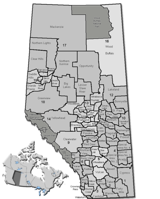
Modul:Location map/data/Alberta municipal districts joylashuv xaritasi taʼrifi boʻlib, an equirectangular projection Albertadagi markerlar va yorliqlarni joylashtirish uchun foydalaniladi. :Modul:Location map/data/Alberta municipal districts|1|3}}|ism}}]]}}}. Markerlar standart xaritada yoki shunga o'xshash xarita tasvirida kenglik va uzunlik koordinatalari bo'yicha joylashtiriladi.
Qoʻllanilishi
Ushbu ta'riflar parametr bilan chaqirilganda quyidagi andozalar tomonidan qo'llaniladi „Alberta municipal districts“:
{{Location map | Alberta municipal districts | …}}{{Location map many | Alberta municipal districts | …}}{{Location map+ | Alberta municipal districts | …}}{{Location map~ | Alberta municipal districts | …}}
Xarita tavsifi
name = Alberta- Standart xarita sarlavhasida foydalanilgan ism
image = Alberta municipal districts.png- Standart xarita tasviri, “Rasm:” yoki “Fayl:”siz
x = (47.8062 + 6.31607*($2+115) + 0.033133*($1-55) -0.163349*($1-55)*($2+115) + 0.0101163*($2+115)*($2+115) -0.00888419*($1-55)*($1-55))- An expression to calculate a location on the map via its longitude; evaluates as 0 along the left edge and 100 along the right edge
y = (45.9081 -0.0512779*($2+115) -8.84793*($1-55) + 0.0102564*($1-55)*($2+115) -0.0167721*($2+115)*($2+115) + 0.0226062*($1-55)*($1-55))- An expression to calculate a location on the map via its latitude; evaluates as 0 along the top edge and 100 along the bottom edge
Xaritalar joylashuvi andozalariga misollar
Test of pins in the corners and corner of Wood Buffalo National Park
Yana qarang
Xaritalar joylashuvi andozalari
- Template:Location map, to display one mark and label using latitude and longitude
- Template:Location map many, to display up to nine marks and labels
- Template:Location map+, to display an unlimited number of marks and labels
Creating new map definitions
return {
	name = 'Alberta',
	x = '(47.8062 + 6.31607*($2+115) + 0.033133*($1-55) -0.163349*($1-55)*($2+115) + 0.0101163*($2+115)*($2+115) -0.00888419*($1-55)*($1-55))',
	y = '(45.9081 -0.0512779*($2+115) -8.84793*($1-55) + 0.0102564*($1-55)*($2+115) -0.0167721*($2+115)*($2+115) + 0.0226062*($1-55)*($1-55))',
	image = 'Alberta municipal districts.png',
}

