
Fayl:USA territorial growth.gif

Bu prevyuning hajmi: 800 × 498 piksel. Boshqa oʻlchamlari: 320 × 199 piksel | 640 × 398 piksel | 921 × 573 piksel.
Asl fayl (921 × 573 piksel, fayl hajmi: 2,01 MB, MIME tipi: image/gif, looped, 10 frames, 50 soniya)
Qisqa izoh
| Taʼrif |
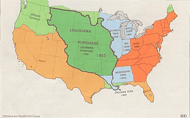
English: US territorial growth 1810–1920, based on the PD USGS maps in Category:Territorial growth maps of the United States.
See key below for explanation of colors.  |
||||||
| Manba |
|
||||||
| Muallif |
|
||||||
| Other versions |
|

Litsenziyalash
This image is in the public domain in the United States because it only contains materials that originally came from the United States Geological Survey, an agency of the United States Department of the Interior. For more information, see the official USGS copyright policy.
|
Fayl tarixi
Faylning biror paytdagi holatini koʻrish uchun tegishli sana/vaqtga bosingiz.
| Sana/Vaqt | Miniatura | Oʻlchamlari | Foydalanuvchi | Izoh | |
|---|---|---|---|---|---|
| joriy | 01:39, 31-May 2006 | | 921 × 573 (2,01 MB) | Roke~commonswiki | longer interval, 3 seconds --> 5 seconds |
| 12:21, 30-May 2006 |  | 921 × 573 (2,67 MB) | Roke~commonswiki | US territorial growth 1810-1920, based on the USGS maps in commons:Category:USA Territorial Growth Maps, put together in Corel Painter IX. The individual maps have this licence: {{PD-USGov-USGS}} If it is necessary for me to licence my contributio |
Fayllarga ishoratlar
Bu faylga quyidagi sahifa bogʻlangan:
Faylning global foydalanilishi
Ushbu fayl quyidagi vikilarda ishlatilyapti:
- bn.wikipedia.org loyihasida foydalanilishi
- en.wikipedia.org loyihasida foydalanilishi
- es.wikipedia.org loyihasida foydalanilishi
- fa.wikipedia.org loyihasida foydalanilishi
- fy.wikipedia.org loyihasida foydalanilishi
- ha.wikipedia.org loyihasida foydalanilishi
- he.wikipedia.org loyihasida foydalanilishi
- nl.wikipedia.org loyihasida foydalanilishi
- pnb.wikipedia.org loyihasida foydalanilishi
- ru.wikipedia.org loyihasida foydalanilishi
- ru.wikinews.org loyihasida foydalanilishi
- sr.wikipedia.org loyihasida foydalanilishi
- tr.wikipedia.org loyihasida foydalanilishi
- ur.wikipedia.org loyihasida foydalanilishi
- www.wikidata.org loyihasida foydalanilishi