
Fayl:Trnava Region - physical map.png

Bu prevyuning hajmi: 425 × 599 piksel. Boshqa oʻlchamlari: 170 × 240 piksel | 340 × 480 piksel | 880 × 1 240 piksel.
Asl fayl (880 × 1 240 piksel, fayl hajmi: 684 KB, MIME tipi: image/png)
| Taʼrif |
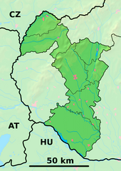
Background map of the Trnava Region, Slovakia, ready for the Geobox template, calibrated at en:Template:Geobox locator Trnava Region Outline map of the Trnava Region, Slovakia, ready for the Geobox template, calibrated at en:Template:Geobox locator Trnava Region |
| Sanasi | (UTC) |
| Manba | |
| Muallif |
|
| This is a retouched picture, which means that it has been digitally altered from its original version. Modifications: fusion. The original can be viewed here: Trnava Region - outline map.svg:
|
Bu fayl Creative Commons asosida litsenziyalangan Attribution- Share Alike 3.0 Unported litsenziyasi.
- Siz erkinsiz:
- ulashishga – ishlanmani nusxalash, tarqatish va uzatish
- remiks qilishga – ishni moslashtirishga
- Quyidagi shartlar asosida:
- atribut – Siz tegishli litsenziyaga havolani taqdim etishingiz va oʻzgartirishlar kiritilganligini koʻrsatishingiz kerak. Siz buni har qanday oqilona yoʻl bilan qilishingiz mumkin, lekin litsenziar Sizni yoki Sizning foydalanishingizni ma'qullashini taklif qiladigan tarzda emas.
- bir xil ulashish – Agar Siz materialni remiks qilsangiz, oʻzgartirsangiz yoki unga asoslansangiz, oʻz hissalaringizni asl nusxadagi kabi bir xil yoki mos litsenziya ostida tarqatishingiz kerak.
Original upload log
This image is a derivative work of the following images:
- File:Trnava_Region_-_background_map.png licensed with PD-Demis
- 2007-10-27T20:31:17Z Caroig 880x1240 (916063 Bytes)
- 2007-10-27T20:25:24Z Caroig 880x1240 (919490 Bytes) fixed alignment
- 2007-10-27T19:52:08Z Caroig 880x1240 (919490 Bytes) == Summary == {{Information |Description=Background map of the Trnava Region, Slovakia, ready for the [[:en:Template:Geobox|Geobox]] template, calibrated at [[:en:Template:Geobox locator Trnava Region]] |Source=Made my myself
- File:Trnava_Region_-_outline_map.svg licensed with Cc-by-sa-3.0,2.5,2.0,1.0, GFDL
- 2007-10-27T19:50:33Z Caroig 1100x1550 (122371 Bytes) == Summary == {{Information |Description=Outline map of the Trnava Region, Slovakia, ready for the [[:en:Template:Geobox|Geobox]] template, calibrated at [[:en:Template:Geobox locator Trnava Region]] |Source=self-made |Date=2
Uploaded with derivativeFX
Fayl tarixi
Faylning biror paytdagi holatini koʻrish uchun tegishli sana/vaqtga bosingiz.
| Sana/Vaqt | Miniatura | Oʻlchamlari | Foydalanuvchi | Izoh | |
|---|---|---|---|---|---|
| joriy | 21:36, 25-May 2014 | | 880 × 1 240 (684 KB) | Sudo77(new) | Reverted to version as of 21:28, 25 May 2014 |
| 21:35, 25-May 2014 |  | 880 × 1 240 (684 KB) | Sudo77(new) | x | |
| 21:28, 25-May 2014 |  | 880 × 1 240 (684 KB) | Sudo77(new) | Trnava Region only | |
| 16:25, 27-Sentyabr 2010 |  | 880 × 1 240 (3,13 MB) | Adehertogh | {{Information |Description=Background map of the Trnava Region, Slovakia, ready for the Geobox template, calibrated at en:Template:Geobox locator Trnava Region Outline map of the Trnava Region, Slovakia, ready for the [[:en:Te |
Fayllarga ishoratlar
Bu faylga quyidagi 2 sahifalar bogʻlangan:
Faylning global foydalanilishi
Ushbu fayl quyidagi vikilarda ishlatilyapti:
- bg.wikipedia.org loyihasida foydalanilishi
- Галанта
- Бродске
- Търнава (Словакия)
- Шаблон:ПК Словакия Търнавски край
- Мостова
- Олдза
- Пиещяни
- Йелка
- Цифер
- Дунайска Стреда
- Водеради
- Серед
- Дехтице
- Смоленице
- Добра вода (Словакия)
- Скалица (Словакия)
- Холич
- Копчани
- Радошовце (окръг Скалица)
- Кути (окръг Сеница)
- Подбранч
- Яблоница
- Приетрж
- Сеница (Словакия)
- Хълбоке
- Градиште под Вратном
- Осуске
- Соботиште
- Приевали
- Долне Дубове
- Болераз
- Катловце
- Букова
- Биньовце
- Богдановце-над-Търнавоу
- Борова (Словакия)
- Брестовани
- Долне Орешани
- Горне Орешани
- Долна Крупа
- Завар
- Бели Костол
- Влъчковце
- Горна Крупа
- Дълга (Словакия)
- Кошолна
- Ружиндол
- Лошонец
- Шелпице
- Шпачинце
Ushbu faylni koʻproq global foydalanishdan koʻring.