
Fayl:Tierra del Fuego location map.svg

Asl fayl (SVG fayl, asl oʻlchamlari 1 535 × 1 550 piksel, fayl hajmi: 824 KB)
Qisqa izoh
| Taʼrif |
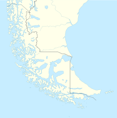
Deutsch: Positionskarte von Feuerland und Umgebung
Quadratische Plattkarte, N-S-Streckung 160 %. Geographische Begrenzung der Karte:
English: Location map of Tierra del Fuego and surroundings
Equirectangular projection, N/S stretching 160 %. Geographic limits of the map:
Español: Ubicación de Tierra del Fuego y alrededores
Proyección equirectangular, N/S 160% de estiramiento. Límites geográficos del mapa:
|
|
| Sanasi | ||
| Manba |
Oʻzimning ishim, using
|
|
| Muallif | NordNordWest | |
| Ruxsat (Bu faylning takror foydalanilishi) |
This file is licensed under the Creative Commons Attribution-Share Alike 3.0 Germany license.
 This file is licensed under the Creative Commons Attribution-Share Alike 3.0 Germany license.
|
|
| Other versions |
Derivative works of this file: |

.svg)

|
This map has been made or improved in the German Kartenwerkstatt (Map Lab). You can propose maps to improve as well.
|
Fayl tarixi
Faylning biror paytdagi holatini koʻrish uchun tegishli sana/vaqtga bosingiz.
| Sana/Vaqt | Miniatura | Oʻlchamlari | Foydalanuvchi | Izoh | |
|---|---|---|---|---|---|
| joriy | 16:20, 5-Mart 2024 | | 1 535 × 1 550 (824 KB) | Janitoalevic | More specific Beagle Channel |
| 01:23, 29-Dekabr 2022 |  | 1 535 × 1 550 (588 KB) | Janitoalevic | Improved borders | |
| 19:41, 3-May 2020 |  | 1 535 × 1 550 (566 KB) | Janitoalevic | Improved Isla de los Estados | |
| 18:47, 3-May 2020 |  | 1 535 × 1 550 (558 KB) | Janitoalevic | Improved | |
| 23:23, 29-Avgust 2017 |  | 1 535 × 1 550 (441 KB) | Janitoalevic | Fixed size | |
| 11:23, 29-Avgust 2017 |  | 1 535 × 1 550 (510 KB) | NordNordWest | Reverted to version as of 20:59, 15 March 2016 (UTC); change of size is catastrophic to some templates | |
| 22:18, 28-Avgust 2017 |  | 1 638 × 1 653 (442 KB) | Janitoalevic | More precise borders and lakes | |
| 20:59, 15-Mart 2016 |  | 1 535 × 1 550 (510 KB) | Janitoalevic | Fixed limits following Google Earth/maps limits | |
| 22:12, 2-Mart 2016 |  | 1 535 × 1 550 (510 KB) | Janitoalevic | Updated | |
| 20:34, 11-Sentyabr 2015 |  | 1 535 × 1 550 (508 KB) | Janitoalevic | Added Southern Patagonian Ice Field (Campo de hielo Patagónico Sur) undefined limits part, since 1998 For more information read: https://en.wikipedia.org/wiki/Southern_Patagonian_Ice_Field#Borderline Now with full resolution. |
Fayllarga ishoratlar
Bu faylga quyidagi 2 sahifalar bogʻlangan:
Faylning global foydalanilishi
Ushbu fayl quyidagi vikilarda ishlatilyapti:
- als.wikipedia.org loyihasida foydalanilishi
- ar.wikipedia.org loyihasida foydalanilishi
- az.wikipedia.org loyihasida foydalanilishi
- ba.wikipedia.org loyihasida foydalanilishi
- bn.wikipedia.org loyihasida foydalanilishi
- ceb.wikipedia.org loyihasida foydalanilishi
- cs.wikipedia.org loyihasida foydalanilishi
- da.wikipedia.org loyihasida foydalanilishi
- de.wikipedia.org loyihasida foydalanilishi
- el.wikipedia.org loyihasida foydalanilishi
- en.wikipedia.org loyihasida foydalanilishi
- Tierra del Fuego
- Ushuaia – Malvinas Argentinas International Airport
- Isla Grande de Tierra del Fuego
- Puerto Williams
- Río Grande, Tierra del Fuego
- Diego Ramírez Islands
- Riesco Island
- Hoste Island
- Viedma (volcano)
- Cerro Torre
- Fitz Roy
- Viedma Lake
- Gallegos River
- Mount Darwin (Andes)
- Puerto Toro
- Dawson Island
- Ildefonso Islands
- Hermite Islands
- Southern Patagonian Ice Field
- Navarino Island
- Cordillera Darwin
- Cordillera Sarmiento
- Londonderry Island
- Hornos Island
- Grey Lake
- Desolación Island
- Clarence Island, Chile
- Gordon Island
- Juan Guillermos Island
Ushbu faylni koʻproq global foydalanishdan koʻring.