
Fayl:Siedlungsgebiet der Kasachen.png

Bu prevyuning hajmi: 800 × 494 piksel. Boshqa oʻlchamlari: 320 × 198 piksel | 640 × 395 piksel | 1 024 × 632 piksel | 1 280 × 791 piksel | 1 679 × 1 037 piksel.
Asl fayl (1 679 × 1 037 piksel, fayl hajmi: 109 KB, MIME tipi: image/png)
Qisqa izoh
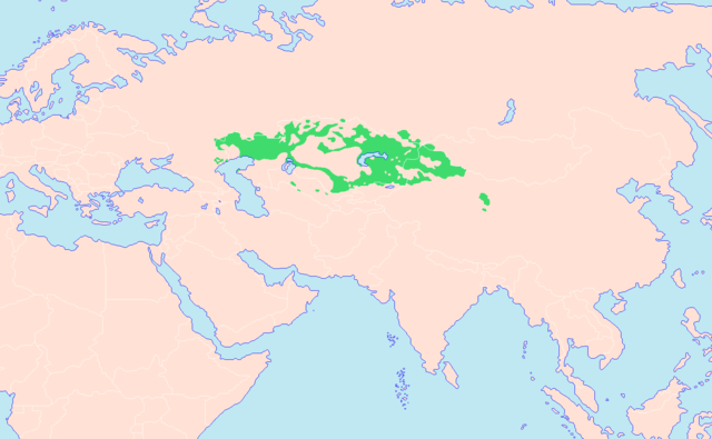
| Taʼrif | Darstellungskarte der kasachischen Siedlungsgebiete. Das durchgängig grüne Gebiet stellt das mehrheitlich von Kasachen bewohnte Territorium dar. Die Hauptquellen der Karte sind zum einen Helmut Glück (Hrsg.): Metzler Lexikon Sprache, Karte Türkische Sprachen (S. 782), Verlag J. B. Metzler Stuttgart — Weimar 1993, ISBN 3-476-00937-8 und Willi Stegner: TaschenAtlas Völker und Sprachen, Karte Asien ― Völker (S. 92/93), Klett-Perthes Verlag Gotha — Stuttgart 2006, ISBN 3-12-828123-8 und zum anderen der Putzger Historischer Weltatlas, Karte Die Völker der Sowjetunion (S. 136), Cornelsen Verlag 1991, ISBN 3-46400176-8. Bei der noch weiteren Überarbeitung bzw. Erweiterung der Karte werden die verwendeten Quellen in Form von Webseiten noch angegeben werden. |
| Sanasi | |
| Manba | Oʻzimning ishim |
| Muallif | Hardcore-Mike |
Litsenziyalash
I, the copyright holder of this work, hereby publish it under the following licenses:

|
Ushbu hujjatdan nusxa ko‘chirish, tarqatish va/yoki o‘zgartirish uchun GNU Erkin guvohnoma litsenziyasi (GNU Free Documentation License), 1.2 va har qanday keyingi versiyalar shartlariga muvofiq ruxsat berilgan yoki Ochiq kodli dasturlar jamiyati (Free Software Foundation) tomonidan chop etilgan; oʻzgarmas boʻlimlarsiz, oldingi muqova matnlari va orqa muqova matnlarisiz. Litsenziya nusxasi GNU Erkin guvohnoma litsenziyasi (GNU Free Documentation License) boʻlimiga kiritilgan. |
Bu fayl Creative Commons asosida litsenziyalangan Attribution- Share Alike 3.0 Unported litsenziyasi.
- Siz erkinsiz:
- ulashishga – ishlanmani nusxalash, tarqatish va uzatish
- remiks qilishga – ishni moslashtirishga
- Quyidagi shartlar asosida:
- atribut – Siz tegishli litsenziyaga havolani taqdim etishingiz va oʻzgartirishlar kiritilganligini koʻrsatishingiz kerak. Siz buni har qanday oqilona yoʻl bilan qilishingiz mumkin, lekin litsenziar Sizni yoki Sizning foydalanishingizni ma'qullashini taklif qiladigan tarzda emas.
- bir xil ulashish – Agar Siz materialni remiks qilsangiz, oʻzgartirsangiz yoki unga asoslansangiz, oʻz hissalaringizni asl nusxadagi kabi bir xil yoki mos litsenziya ostida tarqatishingiz kerak.
Siz oʻzingiz xohlagan litsenziyani tanlashingiz mumkin.
Fayl tarixi
Faylning biror paytdagi holatini koʻrish uchun tegishli sana/vaqtga bosingiz.
| Sana/Vaqt | Miniatura | Oʻlchamlari | Foydalanuvchi | Izoh | |
|---|---|---|---|---|---|
| joriy | 20:52, 4-May 2021 | | 1 679 × 1 037 (109 KB) | Glennznl | Reverted to version as of 11:11, 26 August 2019 (UTC) Rv sockpuppet work |
| 17:09, 27-Avgust 2019 |  | 1 679 × 1 037 (71 KB) | LenguaMapa | ?, it is standard to colour minority or non-inhabidated areas in a lighter colour. nothing disruptive. | |
| 11:11, 26-Avgust 2019 |  | 1 679 × 1 037 (109 KB) | LouisAragon | Rv disruption, restored original content | |
| 12:35, 22-Avgust 2019 |  | 1 679 × 1 037 (71 KB) | LenguaMapa | Population statistics qz-2019, colouring minority/less-populated areas (of Kazakhstan). | |
| 15:59, 9-Sentyabr 2018 |  | 1 679 × 1 037 (109 KB) | MicBy67 | Reverted to version as of 10:54, 17 December 2012 (UTC), ohne Quellenangabe. Und die Karakalpaken sind KEINE Kasachen! | |
| 23:31, 6-Sentyabr 2018 |  | 1 679 × 1 037 (70 KB) | Satoshi Kondo | entspricht nun eher dem stand von 2018 | |
| 10:54, 17-Dekabr 2012 |  | 1 679 × 1 037 (109 KB) | MicBy67 | Ergänzung des kasachischen Gebietes nach: "Atlantis Weltatlas" (Harms List Verlag 1984), ISBN 3-88199-141-7, S. 104/105 und Ernst Schwabe: "Atlas Deutsche Geschichte. Römerzeit bis 1914", Reprint-Verlag Leipzig, ISBN 978-3-8262-1940-5, S. 92/93 (jewe... | |
| 17:23, 16-Dekabr 2012 |  | 1 679 × 1 037 (109 KB) | MicBy67 | Kleinere Überarbeitungen, unter anderem nach; Putzger Historischer Weltatlas, S. 136. Zweisprachige Gebiete entfernt. | |
| 21:34, 24-Noyabr 2012 |  | 1 746 × 1 110 (123 KB) | MicBy67 | {{Information |Description=Darstellungskarte der kasachischen Siedlungsgebiete. Das durchgängig grüne Gebiet stellt das mehrheitlich von Kasachen bewohnte Territorium dar. Das schraffierte Gebiet im Norden symbolisiert das mehrheitlich von Russen und... |
Fayllarga ishoratlar
Bu faylga quyidagi sahifa bogʻlangan:
Faylning global foydalanilishi
Ushbu fayl quyidagi vikilarda ishlatilyapti:
- da.wikipedia.org loyihasida foydalanilishi
- de.wikipedia.org loyihasida foydalanilishi
- fr.wikipedia.org loyihasida foydalanilishi
- hu.wikipedia.org loyihasida foydalanilishi
- kk.wikipedia.org loyihasida foydalanilishi
- ro.wikipedia.org loyihasida foydalanilishi