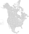
Fayl:North America second level political division 2.svg

Sahifa kontenti boshqa tillarda dastaklanmaydi.
Vikipediya, ochiq ensiklopediya

Asl fayl(SVG fayl, asl oʻlchamlari 512 × 596 piksel, fayl hajmi: 132 KB)

Ushbu fayl Vikiomborga yuklangan boʻlib, boshqa loyihalarda ham qoʻllanilishi mumkin. Uning tavsif sahifasidan olingan maʼlumot quyida keltirilgan.

Qisqa izoh

Taʼrif
English: Map of North America and its second-level political divisions. Canadian provinces, US and Mexican states. Canada, Mexico, United States.

Non-contiguous parts of a states/provinces are "grouped" together with the main area of the state/provinces, so any state/provinces can be coloured in completion with one click anywhere on the state/provinces's area.

Also, all states/provinces have a "id" attached to them, making them easy to find. Select "find" and then enter in the state/provinces's ISO 3166-2 code in the "id" field to find it. The codes can be found here (Canada), here (USA) and here (Mexico).
Sanasi
Manba

Canada and US map: BlankMap-USA-states-Canada-provinces, HI closer.svg by Lokal_Profil.
Mexico map: Mexico template.svg by Mario Fuente Cid
Combined by Alex Covarrubias.

 
The SVG code is valid.
 
This vector image was created with Inkscape, and then manually edited
.
 
W3C-validity not checked.
Muallif Alex Covarrubias
Ruxsat
(Bu faylning takror foydalanilishi)
w:en:Creative Commons
atribut bir xil ulashish
This file is licensed under the Creative Commons Attribution-Share Alike 2.5 Generic license.
Siz erkinsiz:
  • ulashishga – ishlanmani nusxalash, tarqatish va uzatish
  • remiks qilishga – ishni moslashtirishga
Quyidagi shartlar asosida:
  • atribut – Siz tegishli litsenziyaga havolani taqdim etishingiz va oʻzgartirishlar kiritilganligini koʻrsatishingiz kerak. Siz buni har qanday oqilona yoʻl bilan qilishingiz mumkin, lekin litsenziar Sizni yoki Sizning foydalanishingizni ma'qullashini taklif qiladigan tarzda emas.
  • bir xil ulashish – Agar Siz materialni remiks qilsangiz, oʻzgartirsangiz yoki unga asoslansangiz, oʻz hissalaringizni asl nusxadagi kabi bir xil yoki mos litsenziya ostida tarqatishingiz kerak.
Other versions

Derivative works of this file:

Captions

Add a one-line explanation of what this file represents

Items portrayed in this file

tasvirlangan ob'ekt

7 Oktyabr 2007

Fayl tarixi

Faylning biror paytdagi holatini koʻrish uchun tegishli sana/vaqtga bosingiz.

Sana/VaqtMiniaturaOʻlchamlariFoydalanuvchiIzoh
joriy01:51, 23-Noyabr 202001:51, 23-Noyabr 2020 dagi versiya uchun tasvir512 × 596 (132 KB)Ponderosapine210Added the prominent islands of Manitoulin (Ontario) and Isle Royale (Michigan) to the Great Lakes.
23:07, 1-Iyun 201923:07, 1-Iyun 2019 dagi versiya uchun tasvir512 × 596 (130 KB)Fluffy89502added territories, made DC visible, adjusted mexican borders
12:23, 4-Aprel 201412:23, 4-Aprel 2014 dagi versiya uchun tasvir1 712 × 1 992 (270 KB)Lommesmade the borders between the mexican subdivisions the same size as their canadian / us counterparts.
23:23, 8-Dekabr 200723:23, 8-Dekabr 2007 dagi versiya uchun tasvir1 712 × 1 992 (327 KB)Lokal ProfilCode cleanup
07:55, 7-Oktyabr 200707:55, 7-Oktyabr 2007 dagi versiya uchun tasvir1 712 × 1 992 (342 KB)AlexCovarrubias== Summary == {{Information |Description=Map of North America and its second-level political divisions. Canadian provinces, US and Mexican states. Canada, Mexico, United States. |Source=Canada and US map by Alan Rockefeller. Mexico map by Alex Covarrubias

Bu faylga bogʻlangan sahifalar yoʻq.

Faylning global foydalanilishi

Metama’lumot