Kontent qismiga oʻtish

Fayl:Nishitokyo map.png

Sahifa kontenti boshqa tillarda dastaklanmaydi.
Vikipediya, ochiq ensiklopediya

Asl fayl(1 796 × 2 116 piksel, fayl hajmi: 2,5 MB, MIME tipi: image/png)

Ushbu fayl Vikiomborga yuklangan boʻlib, boshqa loyihalarda ham qoʻllanilishi mumkin. Uning tavsif sahifasidan olingan maʼlumot quyida keltirilgan.

Qisqa izoh

Description
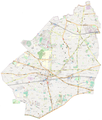
This map of Nishitokyo was created from OpenStreetMap project data, collected by the community. This map may be incomplete, and may contain errors. Don't rely solely on it for navigation.
Sanasi (see file history)
Manba openstreetmap.org
Yaratuvchi
OpenStreetMap contributors
Ruxsat
(Bu faylning takror foydalanilishi)

OpenStreetMap data is available under the Open Database License (details). Map tiles are licensed under the Creative Commons Attribution-ShareAlike 2.0 license (CC-BY-SA 2.0).

This work contains information from OpenStreetMap, which is made available under the Open Database License (ODbL).

The ODbL does not require any particular license for maps produced from ODbL data. Prior to 1 August 2020, map tiles produced by the OpenStreetMap Foundation were licensed under the CC-BY-SA-2.0 license. Maps produced by other people may be subject to other licences.

w:en:Creative Commons
atribut bir xil ulashish
This file is licensed under the Creative Commons Attribution-Share Alike 2.0 Generic license.
Siz erkinsiz:
  • ulashishga – ishlanmani nusxalash, tarqatish va uzatish
  • remiks qilishga – ishni moslashtirishga
Quyidagi shartlar asosida:
  • atribut – Siz tegishli litsenziyaga havolani taqdim etishingiz va oʻzgartirishlar kiritilganligini koʻrsatishingiz kerak. Siz buni har qanday oqilona yoʻl bilan qilishingiz mumkin, lekin litsenziar Sizni yoki Sizning foydalanishingizni ma'qullashini taklif qiladigan tarzda emas.
  • bir xil ulashish – Agar Siz materialni remiks qilsangiz, oʻzgartirsangiz yoki unga asoslansangiz, oʻz hissalaringizni asl nusxadagi kabi bir xil yoki mos litsenziya ostida tarqatishingiz kerak.
 Geotemporal data
Bounding box
N: 35.7622°N
W: 139.516°E E: 139.5704°E
S: 35.7101°N
Georeferencing Georeference the map in Wikimaps Warper If inappropriate please set warp_status = skip to hide.


Litsenziyalash

This work contains information from OpenStreetMap, which is made available under the Open Database License (ODbL).

The ODbL does not require any particular license for maps produced from ODbL data. Prior to 1 August 2020, map tiles produced by the OpenStreetMap Foundation were licensed under the CC-BY-SA-2.0 license. Maps produced by other people may be subject to other licences.

Captions

Add a one-line explanation of what this file represents
Map of Nishitokyo city created from Open Street Map

Items portrayed in this file

tasvirlangan ob'ekt

Nishitokyo inglizcha

image/png

Fayl tarixi

Faylning biror paytdagi holatini koʻrish uchun tegishli sana/vaqtga bosingiz.

Sana/VaqtMiniaturaOʻlchamlariFoydalanuvchiIzoh
joriy13:04, 21-dekabr 202113:04, 21-dekabr 2021 dagi versiya uchun tasvir1 796 × 2 116 (2,5 MB)河太郎輪郭を調整
14:57, 18-dekabr 202114:57, 18-dekabr 2021 dagi versiya uchun tasvir1 796 × 2 116 (2,57 MB)河太郎Uploaded a work by オープンストリートマップ (OpenStreetMap) from https://www.openstreetmap.org/ with UploadWizard

Faylning global foydalanilishi

Ushbu fayl quyidagi vikilarda ishlatilyapti:

Metama’lumot