
Fayl:New 2000 black percent.gif

Bu prevyuning hajmi: 776 × 600 piksel. Boshqa oʻlchamlari: 311 × 240 piksel | 621 × 480 piksel | 994 × 768 piksel | 1 280 × 989 piksel | 2 604 × 2 012 piksel.
Asl fayl (2 604 × 2 012 piksel, fayl hajmi: 649 KB, MIME tipi: image/gif)
Qisqa izoh

|
This ethnographic map image could be re-created using vector graphics as an SVG file. This has several advantages; see Commons:Media for cleanup for more information. If an SVG form of this image is available, please upload it and afterwards replace this template with
{{vector version available|new image name}}.
It is recommended to name the SVG file “New 2000 black percent.svg”—then the template Vector version available (or Vva) does not need the new image name parameter. |
| Taʼrif |
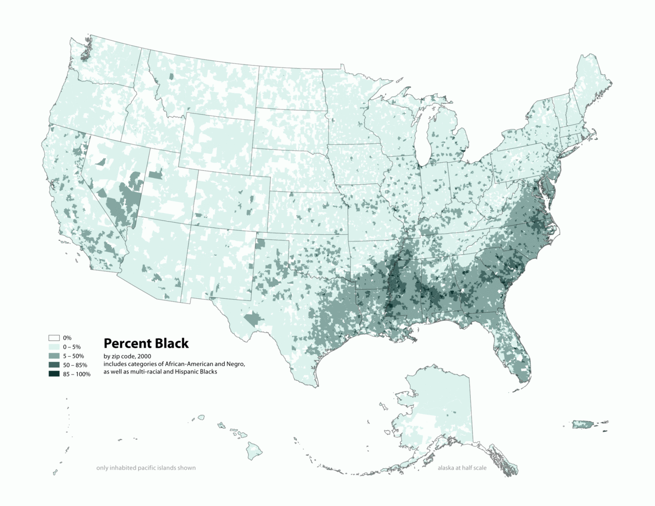
English: Map of contiguous US, showing percentage of population self-reported as "Black," by census tract, 2000. Data source: US Census. |
| Sanasi | 3 Aprel 2006 (original upload date) |
| Manba | Transferred from en.wikipedia to Commons by O'Dea. |
| Muallif | The original uploader was Citynoise at inglizcha Vikipediya. |
Litsenziyalash
This file is licensed under the Creative Commons Attribution-Share Alike 2.5 Generic license.
- Siz erkinsiz:
- ulashishga – ishlanmani nusxalash, tarqatish va uzatish
- remiks qilishga – ishni moslashtirishga
- Quyidagi shartlar asosida:
- atribut – Siz tegishli litsenziyaga havolani taqdim etishingiz va oʻzgartirishlar kiritilganligini koʻrsatishingiz kerak. Siz buni har qanday oqilona yoʻl bilan qilishingiz mumkin, lekin litsenziar Sizni yoki Sizning foydalanishingizni ma'qullashini taklif qiladigan tarzda emas.
- bir xil ulashish – Agar Siz materialni remiks qilsangiz, oʻzgartirsangiz yoki unga asoslansangiz, oʻz hissalaringizni asl nusxadagi kabi bir xil yoki mos litsenziya ostida tarqatishingiz kerak.
Original upload log
The original description page was here. All following user names refer to en.wikipedia.
- 2010-05-01 19:15 Citynoise 2604×2012× (664072 bytes) Added Alaska, Hawaii, and Territories. Also changed from tracts to zip codes.
- 2006-04-03 02:04 Citynoise 1012×691× (78990 bytes) Map of contiguous US, showing percentage of population self-reported as "Black," by census tract, 2000. Data source: US Census. I am the designer and creator of this map and license it under the Creative Commons Attribution ShareAlike 2.5 License. s
Category:Census maps of the United States Category:Maps illustrating African American history Category:African American history
Fayl tarixi
Faylning biror paytdagi holatini koʻrish uchun tegishli sana/vaqtga bosingiz.
| Sana/Vaqt | Miniatura | Oʻlchamlari | Foydalanuvchi | Izoh | |
|---|---|---|---|---|---|
| joriy | 02:48, 31-Dekabr 2011 | | 2 604 × 2 012 (649 KB) | Spideog | {{Information |Description={{en|en:Category:Census maps of the United States en:Category:Maps illustrating African American history en:Category:African American history}} |Source=Transferred from [http://en.wikipedia.org en.wikipedia]; t |
Fayllarga ishoratlar
Bu faylga quyidagi 2 sahifalar bogʻlangan:
Faylning global foydalanilishi
Ushbu fayl quyidagi vikilarda ishlatilyapti:
- af.wikipedia.org loyihasida foydalanilishi
- ar.wikipedia.org loyihasida foydalanilishi
- cs.wikipedia.org loyihasida foydalanilishi
- de.wikipedia.org loyihasida foydalanilishi
- diq.wikipedia.org loyihasida foydalanilishi
- en.wikipedia.org loyihasida foydalanilishi
- fa.wikipedia.org loyihasida foydalanilishi
- fr.wikipedia.org loyihasida foydalanilishi
- fy.wikipedia.org loyihasida foydalanilishi
- he.wikipedia.org loyihasida foydalanilishi
- ht.wikipedia.org loyihasida foydalanilishi
- lfn.wikipedia.org loyihasida foydalanilishi
- pt.wikipedia.org loyihasida foydalanilishi
- ro.wikipedia.org loyihasida foydalanilishi
- ru.wikipedia.org loyihasida foydalanilishi
- test.wikipedia.org loyihasida foydalanilishi
- tl.wikipedia.org loyihasida foydalanilishi
- ur.wikipedia.org loyihasida foydalanilishi