
Fayl:Ndolaflightpath.png
Bu prevyuning hajmi: 800 × 354 piksel. Boshqa oʻlchamlari: 320 × 141 piksel | 1 000 × 442 piksel.
Asl fayl (1 000 × 442 piksel, fayl hajmi: 218 KB, MIME tipi: image/png)
| Taʼrif |
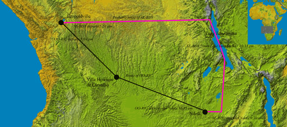
English: Redrawn from map in Air Disaster Volume 4 by Macarthur Job and en:Image:Topography of africa.jpg by User:John. Depicts the flight paths of the two aircraft involved in the death of Dag Hammarskjold on 17 September 1961. |
| Sanasi | 19 Iyul 2007 (original upload date) |
| Manba | Transferred from en.wikipedia to Commons by Tran_Quoc123 using CommonsHelper. |
| Muallif | John at inglizcha Vikipediya |
Litsenziyalash
John at the English Wikipedia, the copyright holder of this work, hereby publishes it under the following license:

|
Ushbu hujjatdan nusxa ko‘chirish, tarqatish va/yoki o‘zgartirish uchun GNU Erkin guvohnoma litsenziyasi (GNU Free Documentation License), 1.2 va har qanday keyingi versiyalar shartlariga muvofiq ruxsat berilgan yoki Ochiq kodli dasturlar jamiyati (Free Software Foundation) tomonidan chop etilgan; oʻzgarmas boʻlimlarsiz, oldingi muqova matnlari va orqa muqova matnlarisiz. Litsenziya nusxasi GNU Erkin guvohnoma litsenziyasi (GNU Free Documentation License) boʻlimiga kiritilgan. |
| Bu fayl Creative Commons asosida litsenziyalangan Attribution- Share Alike 3.0 Unported litsenziyasi. | ||
| Attributsiya: John at the English Wikipedia | ||
| ||
| This licensing tag was added to this file as part of the GFDL licensing update. |
Original upload log
The original description page was here. All following user names refer to en.wikipedia.
- 2007-07-19 20:20 John 1000×442×??? (223714 bytes) Redrawn from map in ''Air Disaster Volume 4'' by Macarthur Job and [[:Image:Topography of africa.jpg]] by User:John. Depicts the flight paths of the two aircraft involved in the death of Dag Hammarskjold on [[17 September]] [[1960]].
Fayl tarixi
Faylning biror paytdagi holatini koʻrish uchun tegishli sana/vaqtga bosingiz.
| Sana/Vaqt | Miniatura | Oʻlchamlari | Foydalanuvchi | Izoh | |
|---|---|---|---|---|---|
| joriy | 13:24, 15-Avgust 2008 | | 1 000 × 442 (218 KB) | File Upload Bot (Magnus Manske) | {{BotMoveToCommons|en.wikipedia}} {{Information |Description={{en|Redrawn from map in ''Air Disaster Volume 4'' by Macarthur Job and en::Image:Topography of africa.jpg by User:John. Depicts the flight paths of the two aircraft involved in the death |
Fayllarga ishoratlar
Bu faylga quyidagi sahifa bogʻlangan:
Faylning global foydalanilishi
Ushbu fayl quyidagi vikilarda ishlatilyapti:
- az.wikipedia.org loyihasida foydalanilishi
- de.wikipedia.org loyihasida foydalanilishi
- es.wikipedia.org loyihasida foydalanilishi
- fr.wikipedia.org loyihasida foydalanilishi
- ja.wikipedia.org loyihasida foydalanilishi
- ru.wikipedia.org loyihasida foydalanilishi
- vi.wikipedia.org loyihasida foydalanilishi
- www.wikidata.org loyihasida foydalanilishi
- zh.wikipedia.org loyihasida foydalanilishi