
Fayl:Map of region of Emilia-Romagna, Italy, with provinces-it.svg

Size of this PNG preview of this SVG file: 800 × 422 piksel. Boshqa oʻlchamlari: 320 × 169 piksel | 640 × 337 piksel | 1 024 × 540 piksel | 1 280 × 675 piksel | 2 560 × 1 349 piksel | 4 800 × 2 530 piksel.
Asl fayl (SVG fayl, asl oʻlchamlari 4 800 × 2 530 piksel, fayl hajmi: 186 KB)
Qisqa izoh
| Taʼrif | (Italian version) |
| Sanasi | |
| Manba | Oʻzimning ishim |
| Muallif | Vonvikken |
| Other versions |
    |


This W3C-unspecified vector image was created with Inkscape .
W3C-validity not checked.

|
This SVG file contains embedded text that can be translated into your language, using any capable SVG editor, text editor or the SVG Translate tool. For more information see: About translating SVG files. |
This vector image includes elements that have been taken or adapted from this file:
This vector image includes elements that have been taken or adapted from this file:
Litsenziyalash
| This work has been released into the public domain by its author, Vonvikken. This applies worldwide. In some countries this may not be legally possible; if so: |
Fayl tarixi
Faylning biror paytdagi holatini koʻrish uchun tegishli sana/vaqtga bosingiz.
| Sana/Vaqt | Miniatura | Oʻlchamlari | Foydalanuvchi | Izoh | |
|---|---|---|---|---|---|
| joriy | 06:19, 19-Sentyabr 2023 | | 4 800 × 2 530 (186 KB) | Quetz72 | File uploaded using svgtranslate tool (https://svgtranslate.toolforge.org/). Added translation for ca. |
| 02:04, 7-Oktyabr 2022 |  | 4 800 × 2 530 (186 KB) | Krepideia | Borders update: migration of the Municipalities of Montecopiolo and Sassofeltrio into the province of Rimini (2021) | |
| 23:31, 15-Sentyabr 2010 |  | 4 800 × 2 530 (186 KB) | Vonvikken | +Minimap | |
| 22:26, 15-Sentyabr 2010 |  | 4 800 × 2 530 (151 KB) | Vonvikken | == {{int:filedesc}} == {{Information |Description={{DescrMapRegionItaly|EMI|Italian}} |Source={{own}} |Author=Vonvikken |Date=2010-09-16 |Permission= |other_versions=100px|Blank[[File: |
Fayllarga ishoratlar
Bu faylga quyidagi sahifa bogʻlangan:
Faylning global foydalanilishi
Ushbu fayl quyidagi vikilarda ishlatilyapti:
- an.wikipedia.org loyihasida foydalanilishi
- ar.wikipedia.org loyihasida foydalanilishi
- bg.wikipedia.org loyihasida foydalanilishi
- ca.wikipedia.org loyihasida foydalanilishi
- cs.wikipedia.org loyihasida foydalanilishi
- cy.wikipedia.org loyihasida foydalanilishi
- da.wikipedia.org loyihasida foydalanilishi
- de.wikipedia.org loyihasida foydalanilishi
- en.wikipedia.org loyihasida foydalanilishi
- Tiber
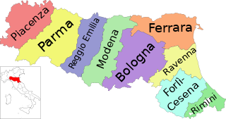
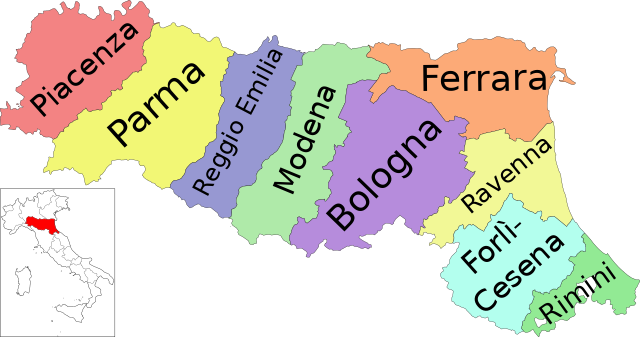
- Emilia-Romagna
- Provinces of Italy
- Province of Reggio Emilia
- Province of Bologna
- Province of Ferrara
- Province of Forlì-Cesena
- Province of Modena
- Province of Parma
- Province of Piacenza
- Province of Ravenna
- Category:Emilia-Romagna
- Province of Rimini
- Template:Emilia–Romagna
- Metropolitan City of Bologna
- List of municipalities of Emilia-Romagna
- Flag of Emilia-Romagna
- Altedo
- Monte Battaglia
- Citadel of Parma
- es.wikipedia.org loyihasida foydalanilishi
- et.wikipedia.org loyihasida foydalanilishi
- fi.wikipedia.org loyihasida foydalanilishi
- ga.wikipedia.org loyihasida foydalanilishi
- hu.wikipedia.org loyihasida foydalanilishi
- incubator.wikimedia.org loyihasida foydalanilishi
- it.wikipedia.org loyihasida foydalanilishi
- it.wikibooks.org loyihasida foydalanilishi
Ushbu faylni koʻproq global foydalanishdan koʻring.