
Fayl:Map of Europe (political).png
Asl fayl (1 596 × 1 043 piksel, fayl hajmi: 86 KB, MIME tipi: image/png)
.png)

|
This map has been uploaded by Electionworld from en.wikipedia.org to enable the |
Qisqa izoh
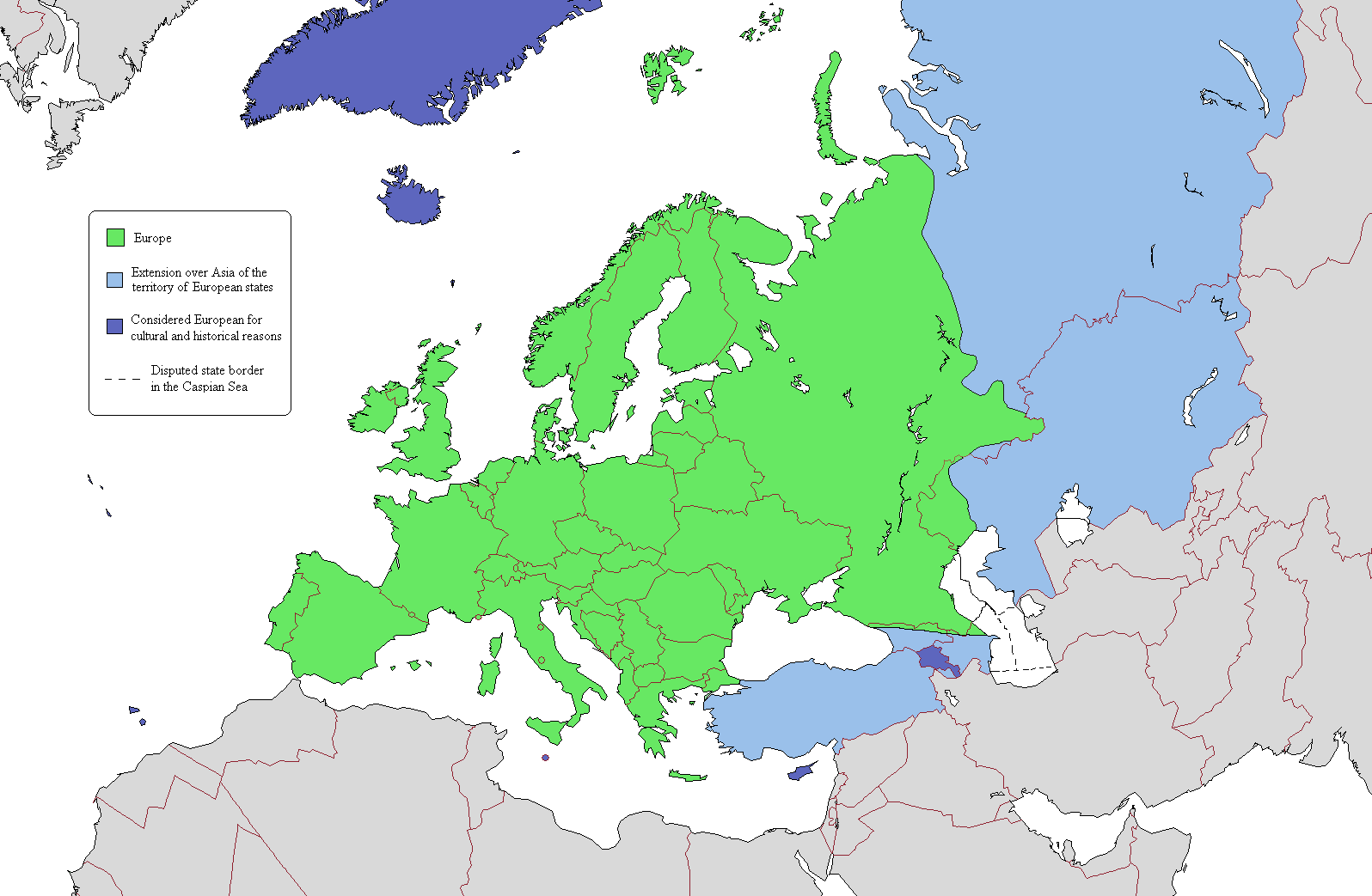
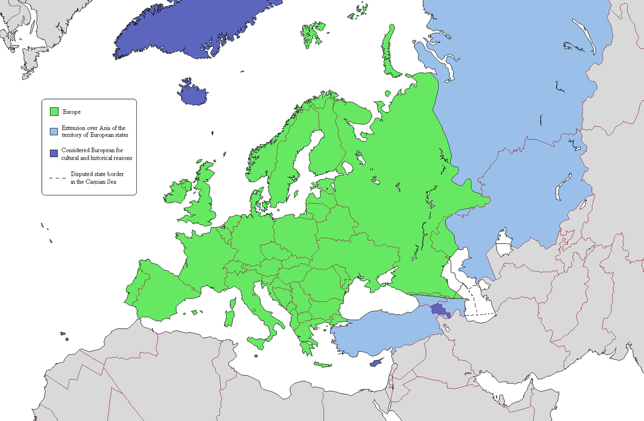
This is a map intended to show the continental boundary of Europe, and the territory of transcontinental states. The map is flawed in a number of ways, and a corrected version is found at [[: File:Europe Asia transcontinental.png]]. Since the latter is a derived version of this one, a copy of the flawed map should be kept around for licencing reasons. The original map appears to have been uploaded to Wikipedia in 2006 by en:User:Alinor.
Derivative works of this file: Europe Asia transcontinental.png
Derivative works of this file: Map of Europe 2007 (political) de.png
_de.png)

|
This map image could be re-created using vector graphics as an SVG file. This has several advantages; see Commons:Media for cleanup for more information. If an SVG form of this image is available, please upload it and afterwards replace this template with
{{vector version available|new image name}}.
It is recommended to name the SVG file “Map of Europe (political).svg”—then the template Vector version available (or Vva) does not need the new image name parameter. |
Litsenziyalash

|
Ushbu hujjatdan nusxa ko‘chirish, tarqatish va/yoki o‘zgartirish uchun GNU Erkin guvohnoma litsenziyasi (GNU Free Documentation License), 1.2 va har qanday keyingi versiyalar shartlariga muvofiq ruxsat berilgan yoki Ochiq kodli dasturlar jamiyati (Free Software Foundation) tomonidan chop etilgan; oʻzgarmas boʻlimlarsiz, oldingi muqova matnlari va orqa muqova matnlarisiz. Litsenziya nusxasi GNU Erkin guvohnoma litsenziyasi (GNU Free Documentation License) boʻlimiga kiritilgan. |
| Bu fayl Creative Commons asosida litsenziyalangan Attribution- Share Alike 3.0 Unported litsenziyasi. | ||
| ||
| This licensing tag was added to this file as part of the GFDL licensing update. |
Fayl tarixi
Faylning biror paytdagi holatini koʻrish uchun tegishli sana/vaqtga bosingiz.
.png&dir=prev)
.png&offset=20110409134150)
.png&offset=&limit=20)
.png&offset=&limit=50)
.png&offset=&limit=100)
.png&offset=&limit=250)
.png&offset=&limit=500)
| Sana/Vaqt | Miniatura | Oʻlchamlari | Foydalanuvchi | Izoh | |
|---|---|---|---|---|---|
| joriy | 22:03, 20-Iyun 2019 | | 1 596 × 1 043 (86 KB) | Rs4815 | Border in the south-east passes along the Greater Caucasus Range |
| 04:05, 16-Aprel 2011 |  | 1 596 × 1 043 (107 KB) | Wsiegmund | Reverted to version as of 19:16, 13 November 2009; see http://commons.wikimedia.org/w/index.php?title=User_talk:Wsiegmund&oldid=53219388#File:Map_of_Europe_.28political.29.png | |
| 03:28, 13-Aprel 2011 |  | 1 596 × 1 043 (71 KB) | Green, White and Gold | Reverted to Dbachmann's version as of 11:49, 8 April 2011 | |
| 02:37, 13-Aprel 2011 |  | 1 596 × 1 043 (71 KB) | Gerge | Reverted to version as of 06:06, 12 April 2011 | |
| 23:12, 12-Aprel 2011 |  | 1 596 × 1 043 (71 KB) | Green, White and Gold | Reverted to Dbachmann's version as of 11:49, 8 April 2011 | |
| 23:09, 12-Aprel 2011 |  | 1 596 × 1 043 (107 KB) | Green, White and Gold | Reverted to Dbachmann's version as of 13:41, 9 April 2011 | |
| 06:06, 12-Aprel 2011 |  | 1 596 × 1 043 (71 KB) | Sigismun | Reverted to version as of 19:54, 10 April 2011 | |
| 01:06, 12-Aprel 2011 |  | 1 596 × 1 043 (107 KB) | Green, White and Gold | Reverted to Dbachmann's version as of 13:41, 9 April 2011 | |
| 19:54, 10-Aprel 2011 |  | 1 596 × 1 043 (71 KB) | ComtesseDeMingrelie | rv. per Commons:Avoid overwriting existing files | |
| 13:41, 9-Aprel 2011 |  | 1 596 × 1 043 (107 KB) | Dbachmann | so, since this map is going to be useless anyway, rv to 3 February 2009 per "Commons:Avoid overwriting existing files." |
Fayllarga ishoratlar
Bu faylga bogʻlangan sahifalar yoʻq.
Faylning global foydalanilishi
Ushbu fayl quyidagi vikilarda ishlatilyapti:
- cs.wikipedia.org loyihasida foydalanilishi
- da.wikipedia.org loyihasida foydalanilishi
- de.wikipedia.org loyihasida foydalanilishi
- en.wikipedia.org loyihasida foydalanilishi
- User:Rashed
- User:Siyavash
- User:Kenzilla
- User:Australian Jezza
- Template:User Eurasian
- User:WiKID Daryl
- User:Royaljared
- User:Angelo De La Paz
- User:PinkPanthress
- Talk:Georgia/Archive 1
- User:Finlandlover
- User talk:BadYodels
- User:Tweisbach
- User:Obaidz96/UBX
- User:Czar Choi
- User:Lenoxus/Subpages/Public/Old
- User:Masumisyan
- User:PKLion
- User:Sweet & Sour Grapes
- User:Shakarian141
- User:Niceguy90
- User:Epileptic Mushroom
- Talk:Armenia/Archive 5
- User:Alexander Rudik
- User:Kunayev
- User:Bush111
- Wikipedia:Graphics Lab/Map workshop/Archive/Apr 2010
- Template talk:Passports/Archive 1
- User:Bgh1111
- User:Lukex115
- User:Lukex115/Userboxen
- User:RussLover
- User:Jextredo
- User:Azndrumsticks
- User:Katangais/Travel
- Wikipedia:Userboxes/Life/Ethnicity
- User:Slawful Justice
- User:Weidorje
- User:Alfredcranham
- User:Chinggis6/Tengerid Traits
- es.wikipedia.org loyihasida foydalanilishi
- fr.wikipedia.org loyihasida foydalanilishi
- it.wikipedia.org loyihasida foydalanilishi
- ko.wikipedia.org loyihasida foydalanilishi
- mk.wikipedia.org loyihasida foydalanilishi
- pl.wikipedia.org loyihasida foydalanilishi
Ushbu faylni koʻproq global foydalanishdan koʻring.
.png)
.png)