
Fayl:Hallig Gröde, Germany, view from the marina.jpg
Bu prevyuning hajmi: 800 × 519 piksel. Boshqa oʻlchamlari: 320 × 208 piksel | 640 × 416 piksel | 1 024 × 665 piksel | 1 280 × 831 piksel | 2 312 × 1 501 piksel.
Asl fayl (2 312 × 1 501 piksel, fayl hajmi: 3,4 MB, MIME tipi: image/jpeg)
Qisqa izoh
| Taʼrif |
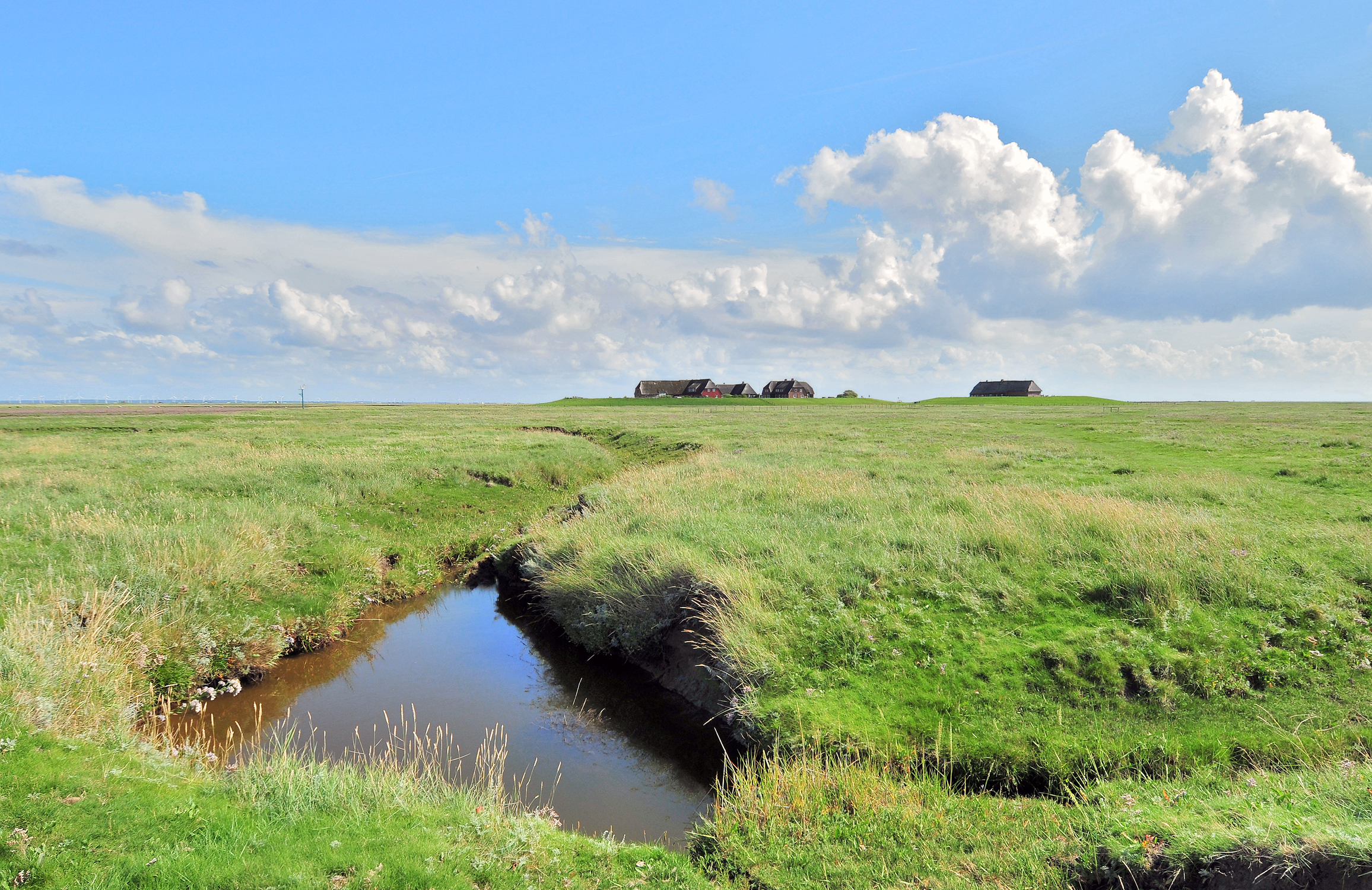
Deutsch: Blick auf die Hallig Gröde. Die Hallig Gröde ist eine der zehn Halligen in dem Nationalpark Schleswig-Holsteinisches Wattenmeer. Hallig Gröde ist fast ganz von einer Steinkante umgeben und ist dadurch bei Sturmfluten vor Landverlust geschützt. Dennoch wird die Hallig Gröde durchschnittlich zwanzig bis dreißig Mal im Jahr bei Landunter vollständig überflutet. Vier Wohnhäuser stehen auf der Knudtswarft (links), und die Kirche mit der Schule und der Lehrerwohnung steht auf der Kirchwarft (rechts). Beide Warften sind von Ringdeichen umgeben, damit sie den Sturmfluten widerstehen können. Die Wohnhäuser besitzen im 1. Stock einen Schutzraum, der auf vier Betonpfeilern steht, die etwa vier Meter im Warftboden gegründet sind. Auf der Knudtswarft befindet sich zwischen den Gebäuden der Fething mit Regenwasser. Auf der Kirchwarft liegt der Friedhof neben dem Kirchen- und Schulgebäude. Seit 1976 ist die Hallig Gröde mit einer Strom- und Wasserleitung mit dem Festland verbunden, es gibt eine Telefonleitung. Die Häuser werden mit Strom beheizt.
English: View to the Hallig Gröde. The Hallig Gröde is an islets in the Schleswig-Holstein Wadden Sea National Park. Hallig Gröde is not protected from storm surges, she is flooded completely twenty to thirty times a year. The Houses are built on high mounds with dykes. Therefore they can withstand the storm surges. The Hallig Gröde has two mounds. The Knudtswarft (left) has four buildings and a pond with rainwater. The Kirchwarft (right) has the graveyard and one building with the church and the school. |
| Sanasi | |
| Manba | Oʻzimning ishim |
| Muallif | Michael Gäbler |
| Attributsiya (required by the license) | © Michael Gäbler / Wikimedia Commons / |
| Camera location | | View this and other nearby images on: OpenStreetMap |
|---|
Litsenziyalash
I, the copyright holder of this work, hereby publish it under the following license:
Bu fayl Creative Commons asosida litsenziyalangan Attribution- Share Alike 3.0 Unported litsenziyasi.
- Siz erkinsiz:
- ulashishga – ishlanmani nusxalash, tarqatish va uzatish
- remiks qilishga – ishni moslashtirishga
- Quyidagi shartlar asosida:
- atribut – Siz tegishli litsenziyaga havolani taqdim etishingiz va oʻzgartirishlar kiritilganligini koʻrsatishingiz kerak. Siz buni har qanday oqilona yoʻl bilan qilishingiz mumkin, lekin litsenziar Sizni yoki Sizning foydalanishingizni ma'qullashini taklif qiladigan tarzda emas.
- bir xil ulashish – Agar Siz materialni remiks qilsangiz, oʻzgartirsangiz yoki unga asoslansangiz, oʻz hissalaringizni asl nusxadagi kabi bir xil yoki mos litsenziya ostida tarqatishingiz kerak.
| Annotations | This image is annotated: View the annotations at Commons |
Fayl tarixi
Faylning biror paytdagi holatini koʻrish uchun tegishli sana/vaqtga bosingiz.
| Sana/Vaqt | Miniatura | Oʻlchamlari | Foydalanuvchi | Izoh | |
|---|---|---|---|---|---|
| joriy | 00:36, 16-Oktyabr 2012 | | 2 312 × 1 501 (3,4 MB) | Michael Gäbler | {{Information |Description= {{de|1= Blick auf die Hallig Gröde. Die Hallig Gröde ist eine der zehn Halligen in dem [[:de:Nationalpark Schleswig-Holsteinisches Wattenmeer|Nationalpark Schleswig-Holsteinisch... |
Fayllarga ishoratlar
Bu faylga quyidagi sahifa bogʻlangan:
Faylning global foydalanilishi
Ushbu fayl quyidagi vikilarda ishlatilyapti:
- ca.wikipedia.org loyihasida foydalanilishi
- ceb.wikipedia.org loyihasida foydalanilishi
- ce.wikipedia.org loyihasida foydalanilishi
- da.wikipedia.org loyihasida foydalanilishi
- de.wikipedia.org loyihasida foydalanilishi
- de.wikivoyage.org loyihasida foydalanilishi
- en.wikipedia.org loyihasida foydalanilishi
- en.wikivoyage.org loyihasida foydalanilishi
- eo.wikipedia.org loyihasida foydalanilishi
- es.wikipedia.org loyihasida foydalanilishi
- eu.wikipedia.org loyihasida foydalanilishi
- hu.wikipedia.org loyihasida foydalanilishi
- lld.wikipedia.org loyihasida foydalanilishi
- mk.wikipedia.org loyihasida foydalanilishi
- no.wikipedia.org loyihasida foydalanilishi
- pl.wikipedia.org loyihasida foydalanilishi
- ro.wikipedia.org loyihasida foydalanilishi
- ru.wikipedia.org loyihasida foydalanilishi
- simple.wikipedia.org loyihasida foydalanilishi
- sr.wikipedia.org loyihasida foydalanilishi
- sv.wikipedia.org loyihasida foydalanilishi
- tr.wikipedia.org loyihasida foydalanilishi
- tt.wikipedia.org loyihasida foydalanilishi
- uk.wikipedia.org loyihasida foydalanilishi
- vi.wikipedia.org loyihasida foydalanilishi
- www.wikidata.org loyihasida foydalanilishi
- zh-min-nan.wikipedia.org loyihasida foydalanilishi