
Fayl:Embalse Guri.JPG

Bu prevyuning hajmi: 600 × 600 piksel. Boshqa oʻlchamlari: 240 × 240 piksel | 480 × 480 piksel | 640 × 640 piksel.
Asl fayl (640 × 640 piksel, fayl hajmi: 158 KB, MIME tipi: image/jpeg)
Qisqa izoh
| Taʼrif |
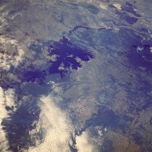
English: The Caroní River and the Guri Reservoir (Venezuela).
Français : La rivière Caroní et le lac de barrage de Guri, au Venezuela. |
| Sanasi | |
| Manba |
Image Science and Analysis Laboratory, NASA-Johnson Space Center. |
| Muallif | NASA, Mission: STS61A |
Location of the Guri Dam (Central Hidroeléctrica Simón Bolívar), on the Caroní River
| Object location | | View this and other nearby images on: OpenStreetMap |
|---|
Litsenziyalash
| This file is in the public domain in the United States because it was solely created by NASA. NASA copyright policy states that "NASA material is not protected by copyright unless noted". (See Template:PD-USGov, NASA copyright policy page or JPL Image Use Policy.) | ||
 |
Warnings:
|
| Annotations | This image is annotated: View the annotations at Commons |

|
This image has been assessed under the valued image criteria and is considered the most valued image on Commons within the scope: Caroní River. You can see its nomination here. |
Fayl tarixi
Faylning biror paytdagi holatini koʻrish uchun tegishli sana/vaqtga bosingiz.
| Sana/Vaqt | Miniatura | Oʻlchamlari | Foydalanuvchi | Izoh | |
|---|---|---|---|---|---|
| joriy | 13:06, 17-Oktyabr 2005 | | 640 × 640 (158 KB) | Venex | Imagen del Embalse de Guri en Venezuela desde el espacio. |
Fayllarga ishoratlar
Bu faylga bogʻlangan sahifalar yoʻq.
Faylning global foydalanilishi
Ushbu fayl quyidagi vikilarda ishlatilyapti:
- be.wikipedia.org loyihasida foydalanilishi
- ca.wikipedia.org loyihasida foydalanilishi
- de.wikipedia.org loyihasida foydalanilishi
- en.wikipedia.org loyihasida foydalanilishi
- es.wikipedia.org loyihasida foydalanilishi
- eu.wikipedia.org loyihasida foydalanilishi
- fr.wikipedia.org loyihasida foydalanilishi
- hr.wikipedia.org loyihasida foydalanilishi
- ig.wikipedia.org loyihasida foydalanilishi
- lt.wikipedia.org loyihasida foydalanilishi
- nl.wikipedia.org loyihasida foydalanilishi
- pt.wikipedia.org loyihasida foydalanilishi
- qu.wikipedia.org loyihasida foydalanilishi
- ru.wikipedia.org loyihasida foydalanilishi
- sh.wikipedia.org loyihasida foydalanilishi
- sl.wikipedia.org loyihasida foydalanilishi
- uk.wikipedia.org loyihasida foydalanilishi
- vi.wikipedia.org loyihasida foydalanilishi
- www.wikidata.org loyihasida foydalanilishi
- zh.wikipedia.org loyihasida foydalanilishi