
Fayl:Cities in China.png
Bu prevyuning hajmi: 759 × 600 piksel. Boshqa oʻlchamlari: 304 × 240 piksel | 607 × 480 piksel | 972 × 768 piksel | 1 280 × 1 012 piksel | 2 560 × 2 023 piksel | 6 246 × 4 937 piksel.
Asl fayl (6 246 × 4 937 piksel, fayl hajmi: 895 KB, MIME tipi: image/png)

|
This image is expected to always be the most recent one. Feel free to update it when needed.
|

|
This file may be updated to reflect new information. If you wish to use a specific version of the file without new updates being mirrored, please upload the required version as a separate file. |
Qisqa izoh
| Taʼrif |
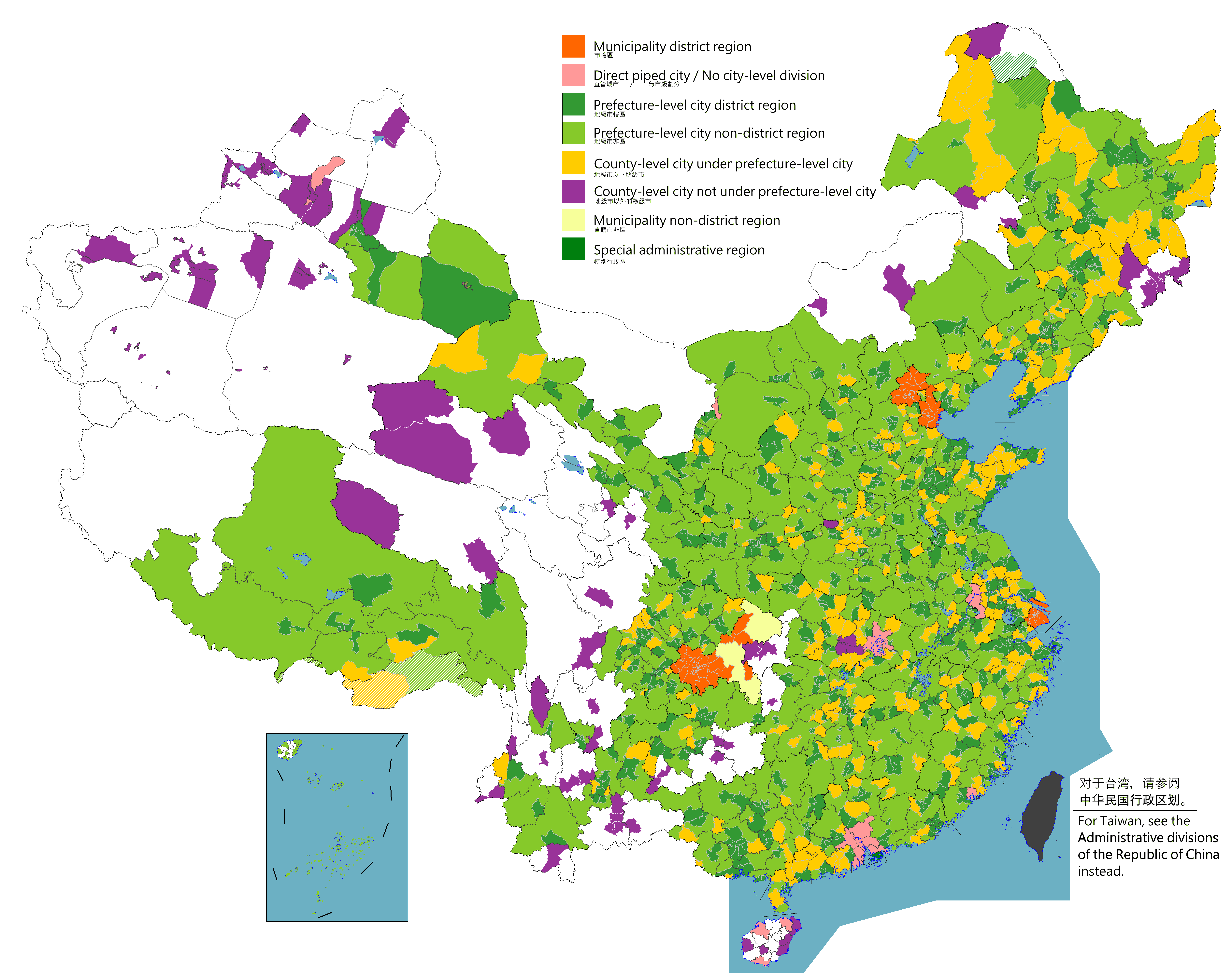
English: Map of China's types of cities.
日本語: 中国の都市の種類の地図。
Русский: Карта типов городов Китая.
Монгол: Хятадын төрлийн хотуудын газрын зураг.
中文(简体):中国城市类型图。(包含未實際控制之疆域)
中文(繁體):中國城市類型圖。 (包含未實際控制之疆域) |
||
| Sanasi |
|
||
| Manba |
Legend: Municipality district region
Direct piped city / No city-level division
Prefecture-level city district region
Prefecture-level city non-district region
County-level city under prefecture-level city
County-level city not prefecture-level city
Municipality non-district region
Special administrative region
Source appearances:
[]
|
||
| Muallif |
|
||
| Ruxsat (Bu faylning takror foydalanilishi) |
Map of China, types of cities: I, the copyright holder of this work, hereby publish it under the following license:
|
.png)
.png)
Litsenziyalash
I, the copyright holder of this work, hereby publish it under the following license:
This file is licensed under the Creative Commons Attribution-Share Alike 4.0 International license.
- Siz erkinsiz:
- ulashishga – ishlanmani nusxalash, tarqatish va uzatish
- remiks qilishga – ishni moslashtirishga
- Quyidagi shartlar asosida:
- atribut – Siz tegishli litsenziyaga havolani taqdim etishingiz va oʻzgartirishlar kiritilganligini koʻrsatishingiz kerak. Siz buni har qanday oqilona yoʻl bilan qilishingiz mumkin, lekin litsenziar Sizni yoki Sizning foydalanishingizni ma'qullashini taklif qiladigan tarzda emas.
- bir xil ulashish – Agar Siz materialni remiks qilsangiz, oʻzgartirsangiz yoki unga asoslansangiz, oʻz hissalaringizni asl nusxadagi kabi bir xil yoki mos litsenziya ostida tarqatishingiz kerak.

|
This locator map image could be re-created using vector graphics as an SVG file. This has several advantages; see Commons:Media for cleanup for more information. If an SVG form of this image is available, please upload it and afterwards replace this template with
{{vector version available|new image name}}.
It is recommended to name the SVG file “Cities in China.svg”—then the template Vector version available (or Vva) does not need the new image name parameter. |
|
|
This map image could be re-created using vector graphics as an SVG file. This has several advantages; see Commons:Media for cleanup for more information. If an SVG form of this image is available, please upload it and afterwards replace this template with
{{vector version available|new image name}}.
It is recommended to name the SVG file “Cities in China.svg”—then the template Vector version available (or Vva) does not need the new image name parameter. |
| Annotations | This image is annotated: View the annotations at Commons |
Fayl tarixi
Faylning biror paytdagi holatini koʻrish uchun tegishli sana/vaqtga bosingiz.
| Sana/Vaqt | Miniatura | Oʻlchamlari | Foydalanuvchi | Izoh | |
|---|---|---|---|---|---|
| joriy | 10:09, 2-Avgust 2023 | | 6 246 × 4 937 (895 KB) | Maanshen | |
| 09:59, 2-Avgust 2023 |  | 6 246 × 4 937 (897 KB) | Maanshen | ||
| 09:51, 2-Avgust 2023 |  | 6 246 × 4 937 (893 KB) | Maanshen | ||
| 08:59, 1-Avgust 2023 |  | 6 246 × 4 937 (891 KB) | Maanshen | ||
| 23:06, 2-Avgust 2022 |  | 6 246 × 4 937 (901 KB) | Maanshen | Update disputed/claimed borders, white with stroke is not claimed and filled in color is claimed | |
| 00:08, 20-Aprel 2022 |  | 6 246 × 4 937 (893 KB) | Maanshen | Fix borders between Ili's Kuytun, Huyanghe, and Karamay | |
| 01:45, 31-Mart 2022 |  | 6 246 × 4 937 (893 KB) | Maanshen | Fix some colors | |
| 00:59, 29-Mart 2022 |  | 6 246 × 4 937 (893 KB) | Maanshen | Fix colors in Shanxi with Fenyang and Xiaoyi | |
| 01:00, 17-Mart 2022 |  | 6 246 × 4 937 (893 KB) | Maanshen | Fix Dongtai as a county-level city | |
| 03:51, 1-Mart 2022 |  | 6 246 × 4 937 (893 KB) | Maanshen | Update Shanghai land reclamation and cpunty border changes as of 2022 |
Fayllarga ishoratlar
Bu faylga quyidagi sahifa bogʻlangan:
Faylning global foydalanilishi
Ushbu fayl quyidagi vikilarda ishlatilyapti:
- en.wikipedia.org loyihasida foydalanilishi
- fi.wikipedia.org loyihasida foydalanilishi
- id.wikipedia.org loyihasida foydalanilishi
- ilo.wikipedia.org loyihasida foydalanilishi
- ko.wikipedia.org loyihasida foydalanilishi
- ku.wikipedia.org loyihasida foydalanilishi
- mk.wikipedia.org loyihasida foydalanilishi
- mn.wikipedia.org loyihasida foydalanilishi
- th.wikipedia.org loyihasida foydalanilishi
- tr.wikipedia.org loyihasida foydalanilishi
- zh.wikipedia.org loyihasida foydalanilishi