
Fayl:Chile location map (+claims, 1775).svg

Asl fayl (SVG fayl, asl oʻlchamlari 1 710 × 2 679 piksel, fayl hajmi: 2,2 MB)
Qisqa izoh
| Taʼrif |
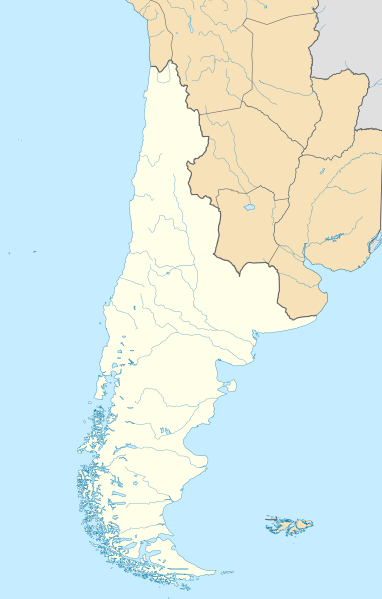
Español: Mapa de localización de la Capitanía General de Chile o Reino de Chile basado en los límites del mapa de la América Meridional hecho por Juan de la Cruz Cano y Olmedilla (1775) y el mapa general del Reyno de Chile de Andrés Baleato (1793) en el sector del desierto de Atacama.
Incluye todas las tierras del continente sudamericano que pobladas o no pertenecían al reino por derecho, entre estas la Patagonia, llamada como Tierras Magallánicas o Chile Moderno. Además incluye el territorio de Cuyo, segregado un año después con la creación del virreinato de la Plata.English: Location map of the Captaincy General of Chile or Kingdom of Chile based on the limits of the map of South America made by Juan de la Cruz Cano y Olmedilla (1775) and the general map of the Kingdom of Chile by Andrés Baleato (1793) in the sector of the Atacama Desert.
It includes all the lands of the South American continent that populated or not belonged to the kingdom by right, among these the Patagonia, called as Magellanic Lands or Modern Chile. It also includes the territory of Cuyo, segregated a year later with the creation of the viceroyalty of La Plata. |
||||||||||||||||||||
| Sanasi | |||||||||||||||||||||
| Manba |
This file was derived from: Chile location map.svg by NordNordWest Reino de Chile según Juan de la Cruz Cano y Olmedilla, 1775.jpg Límite entre Chile y Perú en el río Loa, Plano General del Reyno de Chile en la América Meridional de Andrés Baleato (1793).jpg Oʻzimning ishim |
||||||||||||||||||||
| Muallif |
Andrés Baleato
|
||||||||||||||||||||
| Other versions |
    |
||||||||||||||||||||
.jpg)
.svg)
.jpg)
Litsenziyalash
- Siz erkinsiz:
- ulashishga – ishlanmani nusxalash, tarqatish va uzatish
- remiks qilishga – ishni moslashtirishga
- Quyidagi shartlar asosida:
- atribut – Siz tegishli litsenziyaga havolani taqdim etishingiz va oʻzgartirishlar kiritilganligini koʻrsatishingiz kerak. Siz buni har qanday oqilona yoʻl bilan qilishingiz mumkin, lekin litsenziar Sizni yoki Sizning foydalanishingizni ma'qullashini taklif qiladigan tarzda emas.
- bir xil ulashish – Agar Siz materialni remiks qilsangiz, oʻzgartirsangiz yoki unga asoslansangiz, oʻz hissalaringizni asl nusxadagi kabi bir xil yoki mos litsenziya ostida tarqatishingiz kerak.
Fayl tarixi
Faylning biror paytdagi holatini koʻrish uchun tegishli sana/vaqtga bosingiz.
| Sana/Vaqt | Miniatura | Oʻlchamlari | Foydalanuvchi | Izoh | |
|---|---|---|---|---|---|
| joriy | 20:38, 4-Dekabr 2022 | | 1 710 × 2 679 (2,2 MB) | Janitoalevic | . |
| 20:37, 4-Dekabr 2022 |  | 1 710 × 2 684 (2,2 MB) | Janitoalevic | . | |
| 15:39, 22-Noyabr 2022 |  | 1 710 × 2 679 (2,04 MB) | Janitoalevic | Mejoras | |
| 21:32, 12-Noyabr 2022 |  | 1 710 × 2 679 (1,92 MB) | Janitoalevic | . | |
| 21:22, 12-Noyabr 2022 |  | 1 710 × 2 679 (1,91 MB) | Janitoalevic | Fix | |
| 20:33, 11-Noyabr 2022 |  | 1 710 × 2 679 (1,76 MB) | Janitoalevic | Uploaded own work with UploadWizard |
Fayllarga ishoratlar
Bu faylga quyidagi 2 sahifalar bogʻlangan:
Faylning global foydalanilishi
Ushbu fayl quyidagi vikilarda ishlatilyapti:
- en.wikipedia.org loyihasida foydalanilishi
- si.wikipedia.org loyihasida foydalanilishi
.svg)