
Fayl:Central balkans 1373 1395.png

Bu prevyuning hajmi: 591 × 599 piksel. Boshqa oʻlchamlari: 237 × 240 piksel | 473 × 480 piksel | 757 × 768 piksel | 1 010 × 1 024 piksel | 2 019 × 2 048 piksel | 2 600 × 2 637 piksel.
Asl fayl (2 600 × 2 637 piksel, fayl hajmi: 249 KB, MIME tipi: image/png)
| Taʼrif |
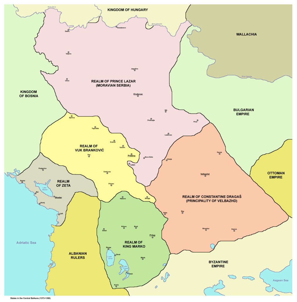
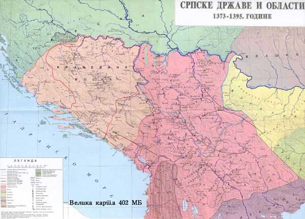
English: States in the Central Balkans that emerged after dissolution of Serbian Empire in the 14th century (1373-1395):
Српски / srpski: Države na centralnom Balkanu koje su nastale posle raspada Srpskog carstva u 14. veku (1373-1395):
Srpskohrvatski / српскохрватски: Države na centralnom Balkanu nastale raspadom Dušanovog carstva u 14. veku (1373-1395):
|
||
| Sanasi | |||
| Manba | English Wikipedia | ||
| Muallif | PANONIAN | ||
| Ruxsat (Bu faylning takror foydalanilishi) |
|
||
| Other versions |
     |
.png)
References
- Istorijski atlas, Geokarta, Beograd, 1999.
- Denis Šehić - Demir Šehić, Istorijski atlas Sveta, Beograd, 2007.
- The Times History of Europe, Times Books, London, 2002.
- Vladimir Ćorović, Ilustrovana istorija Srba, knjiga druga, Beograd, 2005.
- Srpski narod u drugoj polovini XIV i u prvoj polovini XV veka, Zbornik radova, Beograd, 1989.
- Petrit Imami, Srbi i Albanci kroz vekove, Beograd, 2000.
- Miloš Blagojević, Srbija Nemanjića i Hilandar, Beograd - Novi Sad, 1998.
- http://i6.photobucket.com/albums/y226/mindaugas/Srpstvo/srpskezemlje1373do1395.jpg (Note: image from Photobucket used only as a secondary reference)
- http://www.rgz.gov.rs/kart-proizvodi/artikli%5C055610.jpg[dead link]
Fayl tarixi
Faylning biror paytdagi holatini koʻrish uchun tegishli sana/vaqtga bosingiz.
| Sana/Vaqt | Miniatura | Oʻlchamlari | Foydalanuvchi | Izoh | |
|---|---|---|---|---|---|
| joriy | 19:00, 10-Dekabr 2011 | | 2 600 × 2 637 (249 KB) | PANONIAN | aesthetics |
| 10:02, 12-Yanvar 2011 |  | 2 581 × 2 643 (248 KB) | PANONIAN | Reverted to version as of 13:03, 10 March 2010 - it did according to my history atlas. borders in this map are same as in that atlas. if your sources are claiming something else then please draw and upload another map based on such sources | |
| 21:41, 11-Yanvar 2011 |  | 2 581 × 2 643 (312 KB) | Olahus | Serbia didn't border to Wallachia. | |
| 13:03, 10-Mart 2010 |  | 2 581 × 2 643 (248 KB) | PANONIAN | Reverted to version as of 22:22, 8 March 2010 | |
| 22:56, 8-Mart 2010 |  | 1 500 × 1 500 (140 KB) | VízPart | much better version. please upload your own as separate | |
| 22:22, 8-Mart 2010 |  | 2 581 × 2 643 (248 KB) | PANONIAN | Reverted to version as of 12:11, 8 March 2010 - please do not do that | |
| 21:40, 8-Mart 2010 |  | 1 500 × 1 500 (140 KB) | VízPart | better version | |
| 12:11, 8-Mart 2010 |  | 2 581 × 2 643 (248 KB) | PANONIAN | Reverted to version as of 23:35, 13 January 2010 - rv - please upload your version as separate file, I do not agree with that colour change | |
| 02:18, 8-Mart 2010 |  | 1 500 × 1 500 (140 KB) | Ajdebre | improved | |
| 23:35, 13-Yanvar 2010 |  | 2 581 × 2 643 (248 KB) | PANONIAN | improved version |
Fayllarga ishoratlar
Bu faylga bogʻlangan sahifalar yoʻq.
Faylning global foydalanilishi
Ushbu fayl quyidagi vikilarda ishlatilyapti:
- ar.wikipedia.org loyihasida foydalanilishi
- arz.wikipedia.org loyihasida foydalanilishi
- azb.wikipedia.org loyihasida foydalanilishi
- az.wikipedia.org loyihasida foydalanilishi
- ba.wikipedia.org loyihasida foydalanilishi
- bg.wikipedia.org loyihasida foydalanilishi
- bs.wikipedia.org loyihasida foydalanilishi
- ca.wikipedia.org loyihasida foydalanilishi
- cs.wikipedia.org loyihasida foydalanilishi
- de.wikipedia.org loyihasida foydalanilishi
- el.wikipedia.org loyihasida foydalanilishi
- en.wikipedia.org loyihasida foydalanilishi
- et.wikipedia.org loyihasida foydalanilishi
- fr.wikipedia.org loyihasida foydalanilishi
- gl.wikipedia.org loyihasida foydalanilishi
- hr.wikipedia.org loyihasida foydalanilishi
- id.wikipedia.org loyihasida foydalanilishi
- it.wikipedia.org loyihasida foydalanilishi
Ushbu faylni koʻproq global foydalanishdan koʻring.