
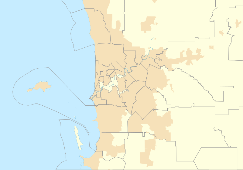
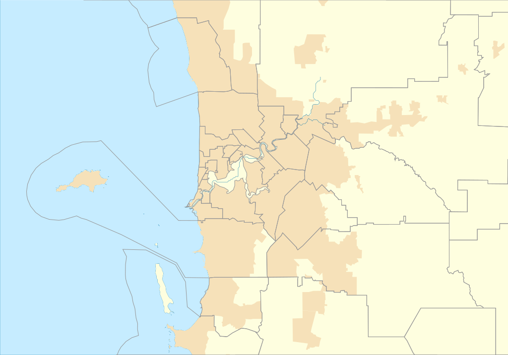
Fayl:Australia Perth location map.svg

Size of this PNG preview of this SVG file: 800 × 559 piksel. Boshqa oʻlchamlari: 320 × 224 piksel | 640 × 447 piksel | 1 024 × 716 piksel | 1 280 × 895 piksel | 2 560 × 1 790 piksel | 1 250 × 874 piksel.
Asl fayl (SVG fayl, asl oʻlchamlari 1 250 × 874 piksel, fayl hajmi: 130 KB)
Qisqa izoh
| Taʼrif |
English: Location map of Perth in Western Australia |
| Sanasi | |
| Manba | Oʻzimning ishim |
| Muallif | Run to the hills, cos the end of the world is soon! |
Litsenziyalash
I, the copyright holder of this work, hereby publish it under the following license:
This file is licensed under the Creative Commons Attribution-Share Alike 4.0 International license.
- Siz erkinsiz:
- ulashishga – ishlanmani nusxalash, tarqatish va uzatish
- remiks qilishga – ishni moslashtirishga
- Quyidagi shartlar asosida:
- atribut – Siz tegishli litsenziyaga havolani taqdim etishingiz va oʻzgartirishlar kiritilganligini koʻrsatishingiz kerak. Siz buni har qanday oqilona yoʻl bilan qilishingiz mumkin, lekin litsenziar Sizni yoki Sizning foydalanishingizni ma'qullashini taklif qiladigan tarzda emas.
- bir xil ulashish – Agar Siz materialni remiks qilsangiz, oʻzgartirsangiz yoki unga asoslansangiz, oʻz hissalaringizni asl nusxadagi kabi bir xil yoki mos litsenziya ostida tarqatishingiz kerak.
Fayl tarixi
Faylning biror paytdagi holatini koʻrish uchun tegishli sana/vaqtga bosingiz.
| Sana/Vaqt | Miniatura | Oʻlchamlari | Foydalanuvchi | Izoh | |
|---|---|---|---|---|---|
| joriy | 00:43, 17-Sentyabr 2016 | | 1 250 × 874 (130 KB) | Run to the hills, cos the end of the world is soon! | User created page with UploadWizard |
Fayllarga ishoratlar
Bu faylga quyidagi 2 sahifalar bogʻlangan:
Faylning global foydalanilishi
Ushbu fayl quyidagi vikilarda ishlatilyapti:
- en.wikipedia.org loyihasida foydalanilishi
- Fremantle
- Cape Peron
- Jualbup Lake
- Mount Eliza (Western Australia)
- Barracks Arch
- Lake Monger
- Herdsman Lake
- Old Jarrah Tree
- Cottesloe Beach
- Forrestdale Lake
- Booragoon Lake
- Albany Bell Castle
- Beatty Park
- Bishop's House, Perth
- Perth Hebrew Congregation
- Thomsons Lake
- Castledare Boys' Home
- Public Transport Centre
- 2014 Perth Hills bushfire
- Module:Location map/data/Australia Perth
- User:Run to the hills, cos the end of the world is soon!/sandbox
- Module:Location map/data/Australia Perth/doc
- Shalom House
- Mundaring Weir Hotel
- Mahogany Inn
- Bassendean Fire Station
- Woodloes Homestead
- Newmarket Hotel
- Challenger Battery
- North Lake (Western Australia)
- Bibra Lake (Western Australia)
- 2021 Beechina bushfire
- User:Garzo/New Sandbox
- fr.wikipedia.org loyihasida foydalanilishi
Ushbu faylni koʻproq global foydalanishdan koʻring.