
Fayl:AucklandPano MC.jpg

Bu prevyuning hajmi: 800 × 121 piksel. Boshqa oʻlchamlari: 320 × 48 piksel | 640 × 97 piksel | 1 024 × 155 piksel | 1 280 × 194 piksel | 2 560 × 388 piksel | 15 000 × 2 271 piksel.
Asl fayl (15 000 × 2 271 piksel, fayl hajmi: 8,74 MB, MIME tipi: image/jpeg)
Qisqa izoh
| Taʼrif |
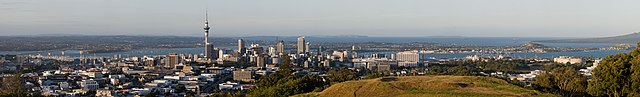
Deutsch: Die Skyline von Auckland City, im Vordergrund ist ein Teil von Mt. Eden sichtbar, links im Hintergrund ist die Auckland Harbour Bridge. Panorama zusammengesetzt aus 2x20 Hochformatbildern.
English: The Skyline of Auckland City, in the foreground a part of Mt. Eden is visible, left in the background is the Auckland Harbour Bridge. Panorama stitched from 2x20 portrait format images.
Français : Vue panoramique d'Auckland. Au premier plan, on peut voir une partie du Mont Eden. A l'arrière plan, on voit le Auckland Harbour Bridge sur la gauche. Panorama obtenu à partir de 40 photos format portrait distribuée en deux rangs.
|
| Sanasi | |
| Manba | Oʻzimning ishim |
| Muallif | Christian Mehlführer, User:Chmehl |
| Ruxsat (Bu faylning takror foydalanilishi) |
This file is licensed under the Creative Commons Attribution 2.5 Generic license.
|
| Camera location | | View this and other nearby images on: OpenStreetMap |
|---|
Assessment
|
This image was selected as picture of the day on Wikimedia Commons for 21 December 2022. It was captioned as follows: English: The skyline of Auckland City. In the foreground a part of Mt. Eden is visible, left in the background is the Auckland Harbour Bridge. Other languages:
Čeština: Panorama novozélandského města Auckland City. V popředí je patrná část návrší Maungawhau (Mount Eden), vlevo v pozadí je lanový most Auckland Harbour Bridge. Deutsch: Die Skyline von Auckland City, im Vordergrund ist ein Teil von Mt. Eden sichtbar, links im Hintergrund ist die Auckland Harbour Bridge. English: The skyline of Auckland City. In the foreground a part of Mt. Eden is visible, left in the background is the Auckland Harbour Bridge. Español: Horizonte de Auckland, Nueva Zelanda. En primer plano se ve una parte de Mount Eden. A la izquierda en el fondo se ve el puente del puerto de Auckland. Français : Vue panoramique d'Auckland. Au premier plan, on peut voir une partie du Mont Eden. A l'arrière plan, on voit le Auckland Harbour Bridge sur la gauche. Magyar: Auckland panorámája. Az előtérben az Eden-hegy egy része látható, balra a háttérben az Auckland Harbour Bridge (Új-Zéland) Português: Horizonte de Auckland, Nova Zelândia. Em primeiro plano se vê uma parte do Mount Eden. À esquerda, no fundo, se vê a ponte do porto de Auckland. Slovenščina: Panorama Aucklanda. V ospredju je viden del gore Eden, levo v ozadju je Aucklandski pristaniški most. Македонски: Широк поглед на градот Окленд, Нов Зеланд. Українська: Горизонт міста Окленд, на передньому плані видно частину гори Іден, ліворуч на задньому плані — оклендський міст Гарбор, Нова Зеландія. 中文: 奥克兰的天际线。可以在前景看到一部份的伊登山,左边的后景是奥克兰港湾桥,全景是以2X20张直立的图片交织而成。 中文(繁體): 奧克蘭的天際線。可以在前景看到一部份的伊登山,左邊的後景是奧克蘭港灣橋,全景是以2X20張直立的圖片交織而成。 |
This image has been assessed using the Quality image guidelines and is considered a Quality image.
|
Fayl tarixi
Faylning biror paytdagi holatini koʻrish uchun tegishli sana/vaqtga bosingiz.
| Sana/Vaqt | Miniatura | Oʻlchamlari | Foydalanuvchi | Izoh | |
|---|---|---|---|---|---|
| joriy | 15:13, 8-Mart 2008 | 15 000 × 2 271 (8,74 MB) | Chmehl | {{Location|36|52|40.6|S|174|45|50.7|E|type:landmark}} {{Information |Description={{de|Die Skyline von Auckland City, im Vordergrund ist ein Teil von Mt. Eden sichtbar, links im Hintergrund ist die Auckland Harbour Bridge. Panorama zusammengesetzt aus 2x20 |
Fayllarga ishoratlar
Bu faylga quyidagi sahifa bogʻlangan:
Faylning global foydalanilishi
Ushbu fayl quyidagi vikilarda ishlatilyapti:
- af.wikipedia.org loyihasida foydalanilishi
- alt.wikipedia.org loyihasida foydalanilishi
- ar.wikipedia.org loyihasida foydalanilishi
- av.wikipedia.org loyihasida foydalanilishi
- cv.wikipedia.org loyihasida foydalanilishi
- de.wikipedia.org loyihasida foydalanilishi
- en.wikipedia.org loyihasida foydalanilishi
- Wikipedia:Featured pictures/Places/Panorama
- Auckland
- User talk:Nikhil B
- User talk:Chmehl
- Talk:Auckland/Archive 2
- Wikipedia:Featured pictures thumbs/36
- Wikipedia:Featured picture candidates/August-2013
- Wikipedia:Featured picture candidates/Auckland Pano
- Wikipedia:Wikipedia Signpost/2013-08-28/Featured content
- Wikipedia:Wikipedia Signpost/Single/2013-08-28
- Wikipedia:Picture of the day/July 2014
- Template:POTD/2014-07-14
- Wikipedia:Main Page history/2014 July 14
- fi.wikipedia.org loyihasida foydalanilishi
- fr.wikipedia.org loyihasida foydalanilishi
- hu.wikipedia.org loyihasida foydalanilishi
- id.wikipedia.org loyihasida foydalanilishi
- kk.wikipedia.org loyihasida foydalanilishi
- ko.wikipedia.org loyihasida foydalanilishi
- lbe.wikipedia.org loyihasida foydalanilishi
- lez.wikipedia.org loyihasida foydalanilishi
- mg.wikipedia.org loyihasida foydalanilishi
- mk.wikipedia.org loyihasida foydalanilishi
- ms.wikipedia.org loyihasida foydalanilishi
- Perbincangan pengguna:Che090572
- Perbincangan pengguna:Syafrein
- Perbincangan pengguna:Naisi
- Perbincangan pengguna:Hezery99
- Perbincangan pengguna:Aiman abmajid
- Perbincangan pengguna:Hariadi
- Perbincangan pengguna:Didie
- Perbincangan pengguna:Siber79
- Perbincangan pengguna:Lokey3310
- Perbincangan pengguna:Alistair
- Perbincangan pengguna:Niduzzi
- Perbincangan pengguna:Malaysiakuh
Ushbu faylni koʻproq global foydalanishdan koʻring.