
Fayl:Aerial-View-Minamitori-Island-1987.jpg

Bu prevyuning hajmi: 800 × 507 piksel. Boshqa oʻlchamlari: 320 × 203 piksel | 640 × 405 piksel | 1 024 × 649 piksel | 1 280 × 811 piksel | 2 824 × 1 789 piksel.
Asl fayl (2 824 × 1 789 piksel, fayl hajmi: 1,09 MB, MIME tipi: image/jpeg)
Qisqa izoh
| Taʼrif |
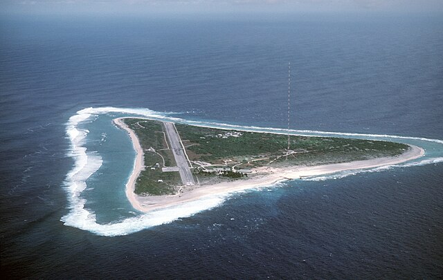
English: Aerial view of Minamitori Island (Minami-Torishima), Japan. There is a runway which supported the US Coast Guard station located there prior to 1993. Minamitori Island is the easternmost island of the Japanese archipelago.
Deutsch: Luftaufnahme der Minamitori Insel (Minami-Torishima), Japan.
日本語: 南鳥島の空中写真。 |
|||
| Sanasi | ||||
| Manba |
|
|||
| Muallif | Chief Master Sergeant Don Sutherland, U.S. Air Force |
Litsenziyalash
This image is a work of a U.S. military or Department of Defense employee, taken or made as part of that person's official duties. As a work of the U.S. federal government, the image is in the public domain in the United States.
|
 |
Fayl tarixi
Faylning biror paytdagi holatini koʻrish uchun tegishli sana/vaqtga bosingiz.
| Sana/Vaqt | Miniatura | Oʻlchamlari | Foydalanuvchi | Izoh | |
|---|---|---|---|---|---|
| joriy | 01:38, 18-Yanvar 2007 | | 2 824 × 1 789 (1,09 MB) | Balcer~commonswiki | ID: DFST8708298 Service Depicted: Coalition or Allied Forces Aerial view of Marcus Island and the runway which supports the US Coast Guard station located there. Marcus Island is the southernmost island in the Japanese chain. Camera Operator: CMSGT |
Fayllarga ishoratlar
Bu faylga quyidagi 2 sahifalar bogʻlangan:
Faylning global foydalanilishi
Ushbu fayl quyidagi vikilarda ishlatilyapti:
- ar.wikipedia.org loyihasida foydalanilishi
- ast.wikipedia.org loyihasida foydalanilishi
- az.wikipedia.org loyihasida foydalanilishi
- be.wikipedia.org loyihasida foydalanilishi
- ca.wikipedia.org loyihasida foydalanilishi
- ceb.wikipedia.org loyihasida foydalanilishi
- cs.wikipedia.org loyihasida foydalanilishi
- de.wikipedia.org loyihasida foydalanilishi
- el.wikipedia.org loyihasida foydalanilishi
- en.wikipedia.org loyihasida foydalanilishi
- es.wikipedia.org loyihasida foydalanilishi
- et.wikipedia.org loyihasida foydalanilishi
- eu.wikipedia.org loyihasida foydalanilishi
- fa.wikipedia.org loyihasida foydalanilishi
- fi.wikipedia.org loyihasida foydalanilishi
- frr.wikipedia.org loyihasida foydalanilishi
- fr.wikipedia.org loyihasida foydalanilishi
- fr.wiktionary.org loyihasida foydalanilishi
- gl.wikipedia.org loyihasida foydalanilishi
- hy.wikipedia.org loyihasida foydalanilishi
- it.wikipedia.org loyihasida foydalanilishi
- ja.wikipedia.org loyihasida foydalanilishi
Ushbu faylni koʻproq global foydalanishdan koʻring.