
Fayl:-IDAHO-L-0011- Teton Dam Flood - Newdale (5811753523).jpg
Asl fayl (2 657 × 1 798 piksel, fayl hajmi: 510 KB, MIME tipi: image/jpeg)
.jpg)
Qisqa izoh
| Taʼrif |
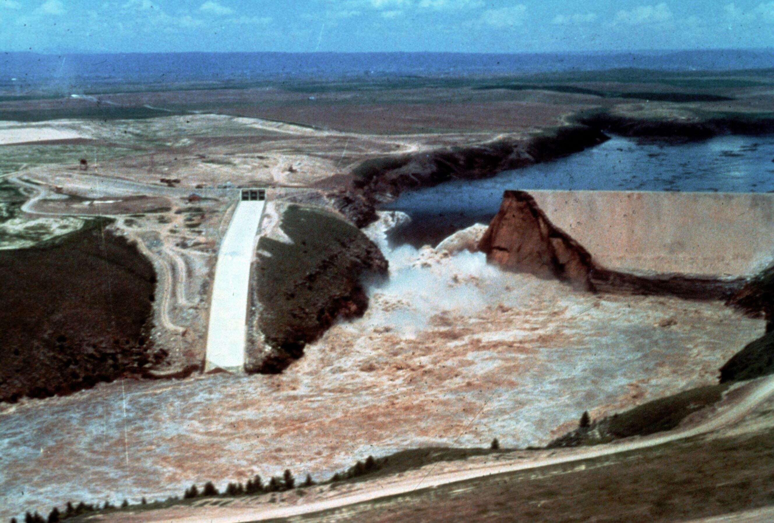
Image Title: Teton Dam Flood - Newdale Date: June 5, 1976 Place: Teton River, Newdale, Idaho Description/Caption: Progressive stages of break in the Dam. Statistics of interest: 80 billion gallons (220,000 acre feet) of water released. Floodwaters' path was seven miles wide in some places (average depth 8-10 feet). 100,000 acres of farmland stripped of topsoil; 13,000 head of livestock killed; 4000 homes, 50 businesses, 3500 farm buildings destroyed. Medium: color transparency Photographer/Maker: Bureau of Reclamation Cite as: ID-L-0011, WaterArchives.org Restrictions: There are no known U.S. copyright restrictions on this image. While the digital image is freely available, it is requested that <a href="http://www.waterarchives.org" target="browser" rel="nofollow">www.waterarchives.org</a> be credited as its source. For higher quality reproductions of the original physical version contact <a href="http://www.waterarchives.org" target="browser" rel="nofollow">www.waterarchives.org</a>, restrictions may apply. |
| Sanasi | |
| Manba | [IDAHO-L-0011] Teton Dam Flood - Newdale |
| Muallif | WaterArchives.org from Las Cruces, New Mexico, United States |
| Camera location | | View this and other nearby images on: OpenStreetMap |
|---|
.jpg¶ms=043.910113_N_-111.539983_E_globe:Earth_type:camera_source:Flickr_&language=uz)
Litsenziyalash
- Siz erkinsiz:
- ulashishga – ishlanmani nusxalash, tarqatish va uzatish
- remiks qilishga – ishni moslashtirishga
- Quyidagi shartlar asosida:
- atribut – Siz tegishli litsenziyaga havolani taqdim etishingiz va oʻzgartirishlar kiritilganligini koʻrsatishingiz kerak. Siz buni har qanday oqilona yoʻl bilan qilishingiz mumkin, lekin litsenziar Sizni yoki Sizning foydalanishingizni ma'qullashini taklif qiladigan tarzda emas.
- bir xil ulashish – Agar Siz materialni remiks qilsangiz, oʻzgartirsangiz yoki unga asoslansangiz, oʻz hissalaringizni asl nusxadagi kabi bir xil yoki mos litsenziya ostida tarqatishingiz kerak.
| This image was originally posted to Flickr by waterarchives at https://flickr.com/photos/23487245@N08/5811753523. It was reviewed on 15 Iyun 2020 by FlickreviewR 2 and was confirmed to be licensed under the terms of the cc-by-sa-2.0. |
Fayl tarixi
Faylning biror paytdagi holatini koʻrish uchun tegishli sana/vaqtga bosingiz.
| Sana/Vaqt | Miniatura | Oʻlchamlari | Foydalanuvchi | Izoh | |
|---|---|---|---|---|---|
| joriy | 15:13, 4-Aprel 2023 | | 2 657 × 1 798 (510 KB) | Rémih | Cropped 8 % horizontally, 7 % vertically using CropTool with precise mode. |
| 09:48, 15-Iyun 2020 |  | 2 882 × 1 940 (548 KB) | Kingofthedead | Transferred from Flickr via #flickr2commons |
Fayllarga ishoratlar
Bu faylga quyidagi sahifa bogʻlangan:
Faylning global foydalanilishi
Ushbu fayl quyidagi vikilarda ishlatilyapti:
- ar.wikipedia.org loyihasida foydalanilishi
- arz.wikipedia.org loyihasida foydalanilishi
- bg.wikipedia.org loyihasida foydalanilishi
- ca.wikipedia.org loyihasida foydalanilishi
- ce.wikipedia.org loyihasida foydalanilishi
- cy.wikipedia.org loyihasida foydalanilishi
- es.wikipedia.org loyihasida foydalanilishi
- eu.wikipedia.org loyihasida foydalanilishi
- fr.wikipedia.org loyihasida foydalanilishi
- ht.wikipedia.org loyihasida foydalanilishi
- it.wikipedia.org loyihasida foydalanilishi
- ky.wikipedia.org loyihasida foydalanilishi
- lld.wikipedia.org loyihasida foydalanilishi
- no.wikipedia.org loyihasida foydalanilishi
- oc.wikipedia.org loyihasida foydalanilishi
- pl.wikipedia.org loyihasida foydalanilishi
- sr.wikipedia.org loyihasida foydalanilishi
- tt.wikipedia.org loyihasida foydalanilishi
- uk.wikipedia.org loyihasida foydalanilishi
- www.wikidata.org loyihasida foydalanilishi
.jpg)