
Fayl:NORTH SIDE AND WEST FRONT - St. Matrona Russian Orthodox Church, Port Heiden, Lake and Peninsula Borough, AK HABS AK,5-POHEI,1B-1.tif

Size of this JPG preview of this TIF file: 800 × 579 piksel. Boshqa oʻlchamlari: 320 × 232 piksel | 640 × 463 piksel | 1 024 × 741 piksel | 1 280 × 927 piksel | 2 560 × 1 853 piksel | 5 000 × 3 620 piksel.
Asl fayl (5 000 × 3 620 piksel, fayl hajmi: 17,26 MB, MIME tipi: image/tiff)
Qisqa izoh
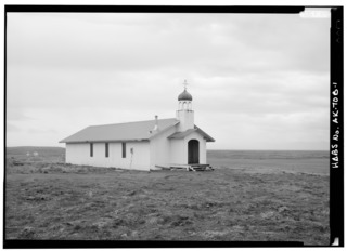
| NORTH SIDE AND WEST FRONT - St. Matrona Russian Orthodox Church, Port Heiden, Lake and Peninsula Borough, AK | ||||
|---|---|---|---|---|
| Fotograf |
Lowe , Jet, creator |
|||
| Title |
NORTH SIDE AND WEST FRONT - St. Matrona Russian Orthodox Church, Port Heiden, Lake and Peninsula Borough, AK |
|||
| Depicted place | Alaska; Lake & Peninsula Borough; Port Heiden | |||
| Sanasi | 1990 | |||
| Medium | 5 x 7 in. | |||
| Current location |
Library of Congress Prints and Photographs Division Washington, D.C. 20540 USA http://hdl.loc.gov/loc.pnp/pp.print |
|||
| Accession number |
HABS AK,5-POHEI,1B-1 |
|||
| Credit line |
|
|||
| Manba | https://www.loc.gov/pictures/item/ak0431.photos.033271p | |||
| Ruxsat (Bu faylning takror foydalanilishi) |
|
|||

| Camera location | | View this and other nearby images on: OpenStreetMap |
|---|
Fayl tarixi
Faylning biror paytdagi holatini koʻrish uchun tegishli sana/vaqtga bosingiz.
| Sana/Vaqt | Miniatura | Oʻlchamlari | Foydalanuvchi | Izoh | |
|---|---|---|---|---|---|
| joriy | 21:45, 25-Iyun 2014 |  | 5 000 × 3 620 (17,26 MB) | Fæ | GWToolset: Creating mediafile for Fæ. HABS batch upload start 25 June 2014 |
Fayllarga ishoratlar
Bu faylga quyidagi sahifa bogʻlangan:
Faylning global foydalanilishi
Ushbu fayl quyidagi vikilarda ishlatilyapti:
- ar.wikipedia.org loyihasida foydalanilishi
- arz.wikipedia.org loyihasida foydalanilishi
- azb.wikipedia.org loyihasida foydalanilishi
- ca.wikipedia.org loyihasida foydalanilishi
- ceb.wikipedia.org loyihasida foydalanilishi
- ce.wikipedia.org loyihasida foydalanilishi
- en.wikipedia.org loyihasida foydalanilishi
- es.wikipedia.org loyihasida foydalanilishi
- eu.wikipedia.org loyihasida foydalanilishi
- fr.wikipedia.org loyihasida foydalanilishi
- ht.wikipedia.org loyihasida foydalanilishi
- it.wikipedia.org loyihasida foydalanilishi
- lld.wikipedia.org loyihasida foydalanilishi
- ml.wikipedia.org loyihasida foydalanilishi
- no.wikipedia.org loyihasida foydalanilishi
- pl.wikipedia.org loyihasida foydalanilishi
- pt.wikipedia.org loyihasida foydalanilishi
- ru.wikipedia.org loyihasida foydalanilishi
- sr.wikipedia.org loyihasida foydalanilishi
- tt.wikipedia.org loyihasida foydalanilishi
- uk.wikipedia.org loyihasida foydalanilishi
- www.wikidata.org loyihasida foydalanilishi