
Fayl:Constantinople mediaeval map.jpg
Bu prevyuning hajmi: 404 × 599 piksel. Boshqa oʻlchamlari: 162 × 240 piksel | 324 × 480 piksel | 518 × 768 piksel | 1 054 × 1 562 piksel.
Asl fayl (1 054 × 1 562 piksel, fayl hajmi: 792 KB, MIME tipi: image/jpeg)
Qisqa izoh
| Taʼrif |
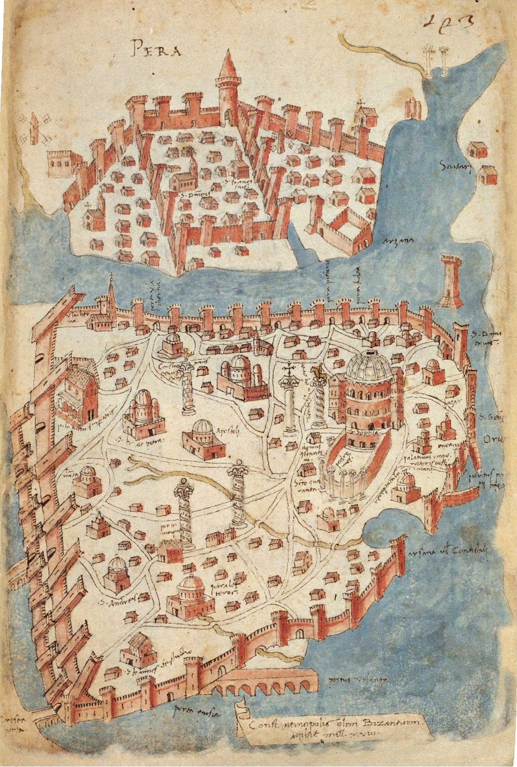
English: Mediaeval map of Constantinople Deutsch: Mittelalterliche Karte von Konstantinopel. Map by Cristoforo Buondelmonti, a Florentine cartographer, from the volume Liber insularum archipelagi (Venice copy) |
|||||
| Sanasi | 1420s-1430s | |||||
| Manba | https://sakipsabancimuzesi.org/tr/object/istanbul-haritasi | |||||
| Muallif | Cristoforo Buondelmonti | |||||
| Ruxsat (Bu faylning takror foydalanilishi) |
|
|||||
| Other versions |
|
|||||
.jpg)
.jpg)
_by_Florentine_cartographer_Cristoforo_Buondelmonte.jpg)
Fayl tarixi
Faylning biror paytdagi holatini koʻrish uchun tegishli sana/vaqtga bosingiz.
| Sana/Vaqt | Miniatura | Oʻlchamlari | Foydalanuvchi | Izoh | |
|---|---|---|---|---|---|
| joriy | 07:35, 8-Yanvar 2021 | | 1 054 × 1 562 (792 KB) | Nanahuatl | better resolution |
| 12:02, 1-May 2008 |  | 450 × 665 (54 KB) | H-stt | http://www.metmuseum.org/explore/byzantium_III/images_large/BYZ1911-lg.jpg | |
| 22:32, 12-Aprel 2008 |  | 296 × 441 (160 KB) | Bender235 | {{Information |Description={{en|Mediaeval map of Constantinople}}<br />{{de|Mittelalterliche Karte von Konstantinopel.}} |Source=German Wikipedia |Date= |Author= |Permission=Public domain |other_versions= }} |
Fayllarga ishoratlar
Bu faylga quyidagi sahifa bogʻlangan:
Faylning global foydalanilishi
Ushbu fayl quyidagi vikilarda ishlatilyapti:
- ar.wikipedia.org loyihasida foydalanilishi
- ast.wikipedia.org loyihasida foydalanilishi
- az.wikipedia.org loyihasida foydalanilishi
- be-tarask.wikipedia.org loyihasida foydalanilishi
- be.wikipedia.org loyihasida foydalanilishi
- bs.wikipedia.org loyihasida foydalanilishi
- ca.wikipedia.org loyihasida foydalanilishi
- ce.wikipedia.org loyihasida foydalanilishi
- cs.wikipedia.org loyihasida foydalanilishi
- cv.wikipedia.org loyihasida foydalanilishi
- da.wikipedia.org loyihasida foydalanilishi
- de.wikipedia.org loyihasida foydalanilishi
- Istanbul
- 1422
- 1203
- Vierter Kreuzzug
- Republik Venedig
- Wikipedia:Hauptseite/Jahrestage/April
- Pera
- Wikipedia:Hauptseite/Jahrestage/April/13
- Belagerung von Konstantinopel (1422)
- Benutzer:GerardM/Battles including the Ottoman Empire
- Wikipedia:Hauptseite/Jahrestage/Monat
- Wikipedia:Hauptseite/Archiv/13. April 2024
- el.wikipedia.org loyihasida foydalanilishi
- en.wikipedia.org loyihasida foydalanilishi
- eo.wikipedia.org loyihasida foydalanilishi
- es.wikipedia.org loyihasida foydalanilishi
- eu.wikipedia.org loyihasida foydalanilishi
- fi.wikipedia.org loyihasida foydalanilishi
- fo.wikipedia.org loyihasida foydalanilishi
- fr.wikipedia.org loyihasida foydalanilishi
- gv.wikipedia.org loyihasida foydalanilishi
Ushbu faylni koʻproq global foydalanishdan koʻring.