
Fayl:Trnc-map.gif
Bundan kattaroq tasvir yoʻq.
Trnc-map.gif (508 × 300 piksel, fayl hajmi: 10 KB, MIME tipi: image/gif)

|
This map has been uploaded by Electionworld from en.wikipedia.org to enable the |

|
The copyright holder of this work allows anyone to use it for any purpose including unrestricted redistribution, commercial use, and modification.
Usage notes:
|
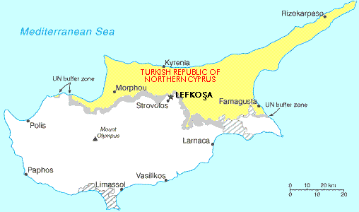
Map showing the Turkish Republic of Northern Cyprus (in yellow). The tiny exclave is called Erenköy.
Fayl tarixi
Faylning biror paytdagi holatini koʻrish uchun tegishli sana/vaqtga bosingiz.
| Sana/Vaqt | Miniatura | Oʻlchamlari | Foydalanuvchi | Izoh | |
|---|---|---|---|---|---|
| joriy | 22:56, 28-Noyabr 2006 | | 508 × 300 (10 KB) | Electionworld | {{ew|en|Expatkiwi}} {{CopyrightedFreeUse}} Map showing the Turkish Republic of Northern Cyprus (in yellow). The tiny exclave is called Erenköy. Category:Maps of Northern Cyprus |
Fayllarga ishoratlar
Bu faylga quyidagi sahifa bogʻlangan:
Faylning global foydalanilishi
Ushbu fayl quyidagi vikilarda ishlatilyapti:
- af.wikipedia.org loyihasida foydalanilishi
- de.wikinews.org loyihasida foydalanilishi
- en.wikipedia.org loyihasida foydalanilishi
- ga.wikipedia.org loyihasida foydalanilishi
- hr.wikipedia.org loyihasida foydalanilishi
- hu.wikipedia.org loyihasida foydalanilishi
- it.wikipedia.org loyihasida foydalanilishi
- nl.wikipedia.org loyihasida foydalanilishi
- ru.wikipedia.org loyihasida foydalanilishi
- su.wikipedia.org loyihasida foydalanilishi
- tr.wikipedia.org loyihasida foydalanilishi