
Fayl:Sveriges Krig 2.12 front.tif

Asl fayl (20 221 × 9 236 piksel, fayl hajmi: 358,94 MB, MIME tipi: image/tiff)
Qisqa izoh
| Warning | The original file is very high-resolution. It might not load properly or could cause your browser to freeze when opened at full size. |
|---|
| Description |
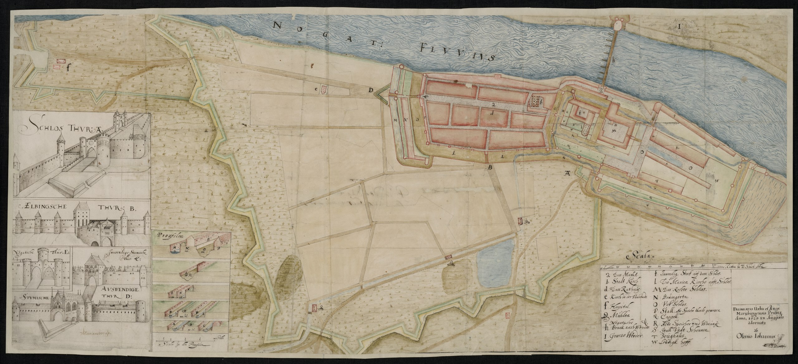
English: Situational map and architectural/design drawings of the Malbork castle.
Svenska: Situationsplan och arkitektur/designritningar av borgen i Malbork |
|||||||||||||||||||||||||||||
| Sanasi | ||||||||||||||||||||||||||||||
| Manba |
https://sok.riksarkivet.se/arkiv/CPk6s4MF9qMoRiLdhDy0G1
|
|||||||||||||||||||||||||||||
| Yaratuvchi |
Olof Hansson Örnehufvud |
|||||||||||||||||||||||||||||
| Geotemporal data | ||||||||||||||||||||||||||||||
| Bounding box |
|
|||||||||||||||||||||||||||||
| Georeferencing | ||||||||||||||||||||||||||||||


Litsenziyalash
|
This work is in the public domain in its country of origin and other countries and areas where the copyright term is the author's life plus 70 years or fewer.
| |
| This file has been identified as being free of known restrictions under copyright law, including all related and neighboring rights. | |
Fayl tarixi
Faylning biror paytdagi holatini koʻrish uchun tegishli sana/vaqtga bosingiz.
| Sana/Vaqt | Miniatura | Oʻlchamlari | Foydalanuvchi | Izoh | |
|---|---|---|---|---|---|
| joriy | 12:15, 9-Noyabr 2021 |  | 20 221 × 9 236 (358,94 MB) | Nils Weinander (Riksarkivet Sverige) | c:User:Rillke/bigChunkedUpload.js: Cleared incorrect EXIF data |
| 13:44, 2-Noyabr 2021 |  | 20 221 × 9 236 (534,35 MB) | Nils Weinander (Riksarkivet Sverige) | Uploaded a work by Olof Hansson Örnehufvud from https://sok.riksarkivet.se/arkiv/CPk6s4MF9qMoRiLdhDy0G1 with UploadWizard |
Fayllarga ishoratlar
Bu faylga quyidagi sahifa bogʻlangan:
Faylning global foydalanilishi
Ushbu fayl quyidagi vikilarda ishlatilyapti:
- en.wikipedia.org loyihasida foydalanilishi
- sv.wikipedia.org loyihasida foydalanilishi
- www.wikidata.org loyihasida foydalanilishi