
Fayl:Sixth Map of Asia Which Includes Arabia Felix, Carmania, and the Persian Gulf.tif

Size of this JPG preview of this TIF file: 781 × 600 piksel. Boshqa oʻlchamlari: 313 × 240 piksel | 625 × 480 piksel | 1 000 × 768 piksel | 1 280 × 983 piksel | 1 333 × 1 024 piksel.
Asl fayl (1 333 × 1 024 piksel, fayl hajmi: 3,91 MB, MIME tipi: image/tiff)
Qisqa izoh
| Taʼrif |
English: This map from Ptolemy’s Geographia was published in 1578 and reprinted on many occasions between 1584 and 1704. It is much more finely engraved than maps in previous Ptolemy editions. The map mentions several places in present-day Qatar (Abucei, Leaniti, Themi, Asateni, and Aegei). Names added to this edition of the map include Mesmites Sinus, Idicar, and a second Idicar, located in present-day Kuwait. This name is similar to the island of “Ichara” found near Magorum Sinus. Contemporary research has confirmed that Kharj is the island known to the ancients as “Icara.” One of the major peninsulas shown on the map is named “Chersonesi Extrema,” near Catara. Modern scholarship has identified Chersonesos as Ras Rakn in present-day Qatar. Ichtyophagorium Sinus is the gulf inhabited by the people identified in ancient histories as the “Fish Eaters.” Claudius Ptolemaeus, known in English as Ptolemy, was an ancient mathematician, astronomer, geographer, and astrologer who was born sometime after 83 A.D., most likely in a town in the Thebaid called Ptolemais Hermiou in Roman Egypt. He lived in Egypt and died in Alexandria around the year 168.
العربية: نُشرت هذه الخريطة من الجغرافيا لبطليموس في ١٥٧٨ وأعيد طبعها عدة مرات بين ١٥٨٤ و١٧٠٤. وقد نُقشت بدرجة أحسن بكثير من خرائط في طبعات سابقة لبطليموس. كما تذكر هذه الخريطة عدة أماكن في قطر حاليا (أبوسي، ليانيتي، ثيمي، أساتيني وأيجي). إن الأسماء التي أضيفت إلى هذه الطبعة من الخريطة تشمل ميسميتس سينوس وإديكار وإديكار ثانية تقع في الكويت حاليا. وهذا الاسم مماثل لجزيرة "إشارة" الموجودة بالقرب من ماغورم سينوس. وقد أكدت البحوث المعاصرة أن خرج هي الجزيرة المعروفة لدى القدماء باسم "إكارة". كما أن إحدى شبه الجزر المبينة على الخريطة مسماة "شيرسونيسي إكستريما"، بالقرب من كاتارا. وقد طابقت البحوث الحديثة شيرسونيسوس برأس ركن في قطر حاليا. إشتيوفاغوريوم سينوس هو الخليج الذي يسكنه الناس المعروفون في التواريخ القديمة باسم "آكلي السمك". كان كلاوديوس بتولوميوس، الذي يعرف بالإنجليزية باسم بتوليمي، عالما قديما في الرياضيات والفلك والجغرافيا والتنجيم وقد ولد في وقت ما بعد ٨٣ ميلادية، على الأرجح في بلدة في طيبة اسمها بتوليميوس هيرميو في مصر الرومانية. عاش في مصر وتوفي في الإسكندرية حوالي سنة ١٦٨.
Español: Este mapa de la Geographia de Ptolomeo se publicó en 1578 y fue reimpreso en numerosas ocasiones entre 1584 y 1704. Está mucho más finamente grabado que los mapas en ediciones previas de Ptolomeo. El mapa menciona varios lugares en Qatar actual (Abucei, Leaniti, Themi, Asateni y Aegei). Los nombres añadidos a esta edición del mapa incluyen Mesmites Sinus, Idicar y un segundo Idicar, ubicado en el actual Kuwait. Este nombre es similar a la isla de "Ichara" que se encuentra cerca de Magorum Sinus. La investigación contemporánea ha confirmado que Kharj es la isla conocida entre los antiguos como "Icara". Una de las principales penínsulas que se muestran en el mapa se llama "Chersonesi Extrema", cerca de Catara. Los eruditos modernos han identificado a Chersonesos como a Ras Rakn en el actual Qatar. Ichtyophagorium Sinus es el golfo habitado por las personas identificadas en la historia antigua como los "Comedores de pescado". Claudius Ptolemaeus, conocido en español como Ptolomeo, fue un antiguo matemático, astrónomo, geógrafo y astrólogo que nació en algún momento después de 83 d.C., probablemente en una ciudad en Thebaid llamada Ptolemais Hermiou en el Egipto romano. Vivió en Egipto y murió en Alejandría alrededor del año 168.
فارسی: نقشهٔ جهان بطلمیوس. منتشرشده در ۱۵۷۸ میلادی. نشاندهندهٔ شبه جزیرهٔ عربستان، کارمانیا و خلیج فارس.
Français : Cette carte de la Geographia de Ptolémée fut publiée en 1578 et réimprimée plusieurs fois entre 1584 et 1704. Sa gravure est bien plus délicate que les cartes des éditions précédentes de Ptolémée. La carte mentionne plusieurs lieux dans l'actuel Qatar (Abucei, Leaniti, Themi, Asateni, et Aegei). Les noms ajoutés sur cette édition de la carte comprennent Mesmites Sinus, Idicar, et un second Idicar, situés dans l'actuel Koweït. Ce nom est similaire à l'Île d'“Ichara” qui se trouve près de Magorum Sinus. La recherche contemporaine a confirmé que Khark est l'île connue par les anciens comme "Icara". L'une des péninsules principales montrées sur la carte est nommée “Chersonesi Extrema” près de Catara. La recherche moderne a identifié Chersonesos comme étant Ras Rakn dans l'actuel Qatar. Ichtyophagorium Sinus est le golfe habité par le peuple identifié dans les récits anciens comme les "mangeurs de poisson.” Claudius Ptolemaeus, connu en français comme Ptolémée était un mathématicien, astronome, géographe, et astrologue de l'antiquité qui naquit vers 83 après J.-C, probablement dans une ville de la Thébaïde appelée Ptolemais Hermiou dans l'Égypte romaine. Il vécut en Égypte et mourut à Alexandrie vers l'an 168.
Português: Este mapa da Geographia de Ptolomeu, foi publicado em 1578 e reimpresso em várias ocasiões entre 1584 e 1704. É gravado com muito mais requinte do que os mapas de Ptolomeu de edições anteriores . O mapa menciona vários lugares no atual Catar (Abucei, Leaniti, Themi, Asateni e Aegei). Os nomes acrescentados a esta edição do mapa incluem: Mesmites Sinus, Idicar e um segundo Idicar, localizado no atual Kuwait. Este nome é semelhante ao da ilha de "Ichara", encontrada próximo a Magorum Sinus. Pesquisas contemporâneas confirmam que Kharj é a ilha conhecida pelos antigos como "Icara". Uma das principais penínsulas mostradas no mapa é chamada de "Chersonesi Extrema," próximo a Catara. Estudiosos modernos identificam Chersonesos como Ras Rakn, no atual Catar. Ichtyophagorium Sinus é o golfo habitado pelo povo identificado na antiguidade como "Comedores de Peixe." Claudius Ptolemaeus, conhecido em Inglês como Ptolemy (Ptolomeu), foi um matemático, astrônomo, geógrafo e astrólogo da antiguidade que nasceu em algum período após 83 d.C., provavelmente em uma cidade do Thebaid chamada Ptolemais Hermiou, no Egito romano. Ele viveu no Egito e morreu em Alexandria por volta do ano 168.
Русский: Эта карта из птолемеевской "Geographia" была издана в 1578 году и переиздавалась несколько раз в период между 1584 и 1704 годом. Это более четкая гравюра по сравнению с картами предшествующих изданий трудов Птолемея. На карте упомянуто несколько мест в современном Катаре (Абусей, Леанити, Теми, Асатени и Аегей). В этом издании добавлены следующие названия: Месмитес Синус, Идикар и второй Идикар, расположенный в современном Кувейте. Название похоже на остров Ичара близ Магорум Синус. Современные исследования подтвердили, что Хардж — это остров, известный древним под названием Икара. Главный полуостров, отмеченный на карте, называется "Chersonesi Extrema", рядом с Катара. Согласно современным исследованиям, Херсонес идентифицирован как Рас Ракн в нынешнем Катаре. "Ichtyophagorium Sinus" — это залив, по берегам которого живет народ, называемый в древних сказаниях "рыбоедами". Клавдий Птолемей, известный в англоговорящем мире как Птолемей, был древним математиком, астрономом, географом и астрологом, родившимся после 83 г. по Р. Х., по всей видимости в Фивах, называемых Ptolemais Hermiou, в римском Египте. Он жил в Египте и умер в Александрии примерно в 168 году.
中文(简体):这幅出自托勒密 《地理学指南》 的地图出版于 1578 年,1584 年至 1704 年期间曾多次重印。 与之前的托勒密版地图相比,该地图在刻版上要精细得多。 该地图提到了位于当今卡塔尔境内的多处地点(Abucei、Leaniti、Themi、Asateni 和 Aegei)。 该版地图所添加的名称包括 Mesmites Sinus、Idicar 和第二处 Idicar(位于今科威特境内)。 该名称与在 Magorum Sinus 附近发现的“Ichara”岛屿的名称相类似。 现代的研究已经确认 Kharj 就是古人称作“Icara”的岛屿。 该地图所标注的主要半岛之一被标注为“Chersonesi Extrema”,位于 Catara 附近。 现代学术研究已经确认 Chersonesos 就是位于今卡塔尔境内的 Ras Rakn。 Ichtyophagorium Sinus 是一处古代历史中被称为“食鱼族”所居住的海湾。 Claudius Ptolemaeus 在英语中写作 Ptolemy(托勒密),是一位古代的数学家、天文学家、地理学家和占星家。托勒密约出生在公元 83 年之后,最有可能的出生地是罗马统治时期埃及的底比斯地区城镇 Ptolemais Hermiou。 他住在埃及,168 年前后死于亚历山大城。 |
||||||||||||||||||||
| Sanasi | |||||||||||||||||||||
| Manba |
|
||||||||||||||||||||
| Muallif |
|
||||||||||||||||||||
| Other versions |
|
||||||||||||||||||||


Litsenziyalash
|
This work is in the public domain in its country of origin and other countries and areas where the copyright term is the author's life plus 100 years or fewer. | |
| This file has been identified as being free of known restrictions under copyright law, including all related and neighboring rights. | |
Fayl tarixi
Faylning biror paytdagi holatini koʻrish uchun tegishli sana/vaqtga bosingiz.
| Sana/Vaqt | Miniatura | Oʻlchamlari | Foydalanuvchi | Izoh | |
|---|---|---|---|---|---|
| joriy | 03:00, 4-Sentyabr 2011 | 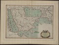 | 1 333 × 1 024 (3,91 MB) | ZxxZxxZ |
Fayllarga ishoratlar
Bu faylga quyidagi sahifa bogʻlangan:
Faylning global foydalanilishi
Ushbu fayl quyidagi vikilarda ishlatilyapti:
- arz.wikipedia.org loyihasida foydalanilishi
- cs.wikipedia.org loyihasida foydalanilishi
- en.wikipedia.org loyihasida foydalanilishi
- fa.wikipedia.org loyihasida foydalanilishi
- hu.wikipedia.org loyihasida foydalanilishi
- it.wikipedia.org loyihasida foydalanilishi
- nl.wikipedia.org loyihasida foydalanilishi