
Fayl:Mt Vesuvius 79 AD eruption.svg

Size of this PNG preview of this SVG file: 800 × 482 piksel. Boshqa oʻlchamlari: 320 × 193 piksel | 640 × 386 piksel | 1 024 × 617 piksel | 1 280 × 771 piksel | 2 560 × 1 542 piksel.
Asl fayl (SVG fayl, asl oʻlchamlari 800 × 482 piksel, fayl hajmi: 87 KB)
Qisqa izoh
| Taʼrif |
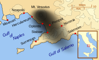
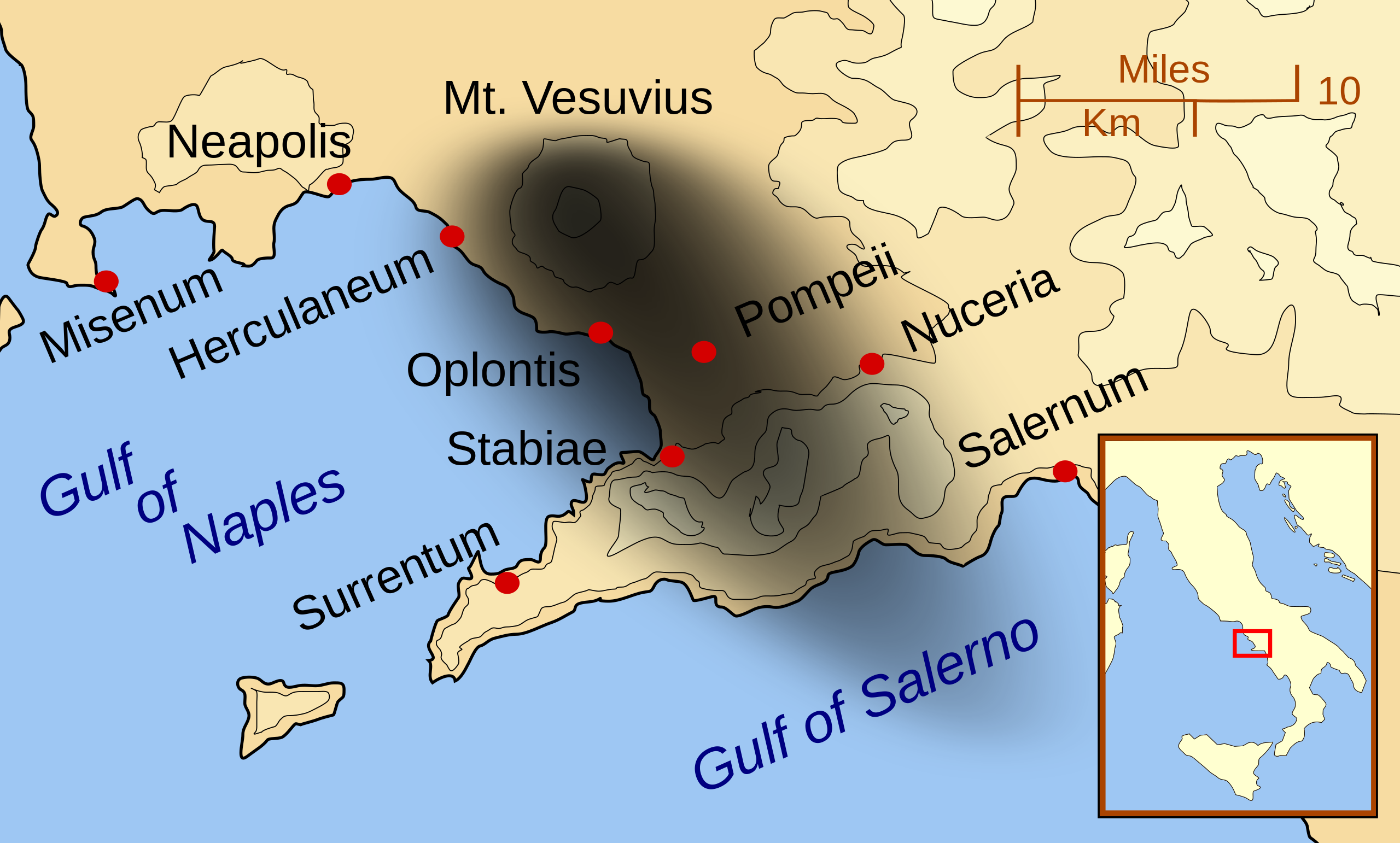
English: A map showing the cities and towns affected by the eruption of Mount Vesuvius in 79 AD. The general shape of the ash and cinder fall (see w:en:pyroclast) is shown by the dark area to the southeast of Mt Vesuvius. (P.S. It seems strange to show the modern day English names for the two bodies of water - I am open to suggestions).
This map shows lines and uses the Mercator projection (although that is not important on a map of this scale). North is, as usual, at the top of the map. |
| Sanasi | |
| Manba | Oʻzimning ishim |
| Muallif | MapMaster |
| Other versions |
[]
|


|
This SVG file contains embedded text that can be translated into your language, using any capable SVG editor, text editor or the SVG Translate tool. For more information see: About translating SVG files. |
Litsenziyalash
I, the copyright holder of this work, hereby publish it under the following licenses:

|
Ushbu hujjatdan nusxa ko‘chirish, tarqatish va/yoki o‘zgartirish uchun GNU Erkin guvohnoma litsenziyasi (GNU Free Documentation License), 1.2 va har qanday keyingi versiyalar shartlariga muvofiq ruxsat berilgan yoki Ochiq kodli dasturlar jamiyati (Free Software Foundation) tomonidan chop etilgan; oʻzgarmas boʻlimlarsiz, oldingi muqova matnlari va orqa muqova matnlarisiz. Litsenziya nusxasi GNU Erkin guvohnoma litsenziyasi (GNU Free Documentation License) boʻlimiga kiritilgan. |
This file is licensed under the Creative Commons Attribution-Share Alike 3.0 Unported, 2.5 Generic, 2.0 Generic and 1.0 Generic license.
- Siz erkinsiz:
- ulashishga – ishlanmani nusxalash, tarqatish va uzatish
- remiks qilishga – ishni moslashtirishga
- Quyidagi shartlar asosida:
- atribut – Siz tegishli litsenziyaga havolani taqdim etishingiz va oʻzgartirishlar kiritilganligini koʻrsatishingiz kerak. Siz buni har qanday oqilona yoʻl bilan qilishingiz mumkin, lekin litsenziar Sizni yoki Sizning foydalanishingizni ma'qullashini taklif qiladigan tarzda emas.
- bir xil ulashish – Agar Siz materialni remiks qilsangiz, oʻzgartirsangiz yoki unga asoslansangiz, oʻz hissalaringizni asl nusxadagi kabi bir xil yoki mos litsenziya ostida tarqatishingiz kerak.
Siz oʻzingiz xohlagan litsenziyani tanlashingiz mumkin.
| Annotations | This image is annotated: View the annotations at Commons |
Fayl tarixi
Faylning biror paytdagi holatini koʻrish uchun tegishli sana/vaqtga bosingiz.
| Sana/Vaqt | Miniatura | Oʻlchamlari | Foydalanuvchi | Izoh | |
|---|---|---|---|---|---|
| joriy | 01:55, 24-Fevral 2014 | | 800 × 482 (87 KB) | Ras67 | ditto |
| 01:42, 24-Fevral 2014 |  | 644 × 388 (88 KB) | Ras67 | frame removed | |
| 01:07, 16-Oktyabr 2007 |  | 652 × 396 (113 KB) | MapMaster | corrected mis-named Gulf of Salerno | |
| 04:02, 15-Oktyabr 2007 |  | 652 × 396 (112 KB) | MapMaster | Dropped Title sqaure, and added towns and names of the 2 bays. | |
| 05:16, 14-Oktyabr 2007 |  | 652 × 454 (126 KB) | MapMaster | Minor changes made after seeing how it's rendered by Wikimedia | |
| 05:11, 14-Oktyabr 2007 |  | 355 × 247 (125 KB) | MapMaster | {{Information |Description=A map showing the cities and town affected by the eruption of Mount Vesuvius in 79 AD. The general shape of the ash and cinder fall is shown by the dark area to the southeast of Mt Vesuvious. |Source=self-made |Date=October 200 |
Fayllarga ishoratlar
Bu faylga quyidagi sahifa bogʻlangan:
Faylning global foydalanilishi
Ushbu fayl quyidagi vikilarda ishlatilyapti:
- ar.wikipedia.org loyihasida foydalanilishi
- bn.wikipedia.org loyihasida foydalanilishi
- ca.wikipedia.org loyihasida foydalanilishi
- cs.wikipedia.org loyihasida foydalanilishi
- da.wikipedia.org loyihasida foydalanilishi
- de.wikipedia.org loyihasida foydalanilishi
- el.wikipedia.org loyihasida foydalanilishi
- en.wikipedia.org loyihasida foydalanilishi
- eo.wikipedia.org loyihasida foydalanilishi
- es.wikipedia.org loyihasida foydalanilishi
- eu.wikipedia.org loyihasida foydalanilishi
- fa.wikipedia.org loyihasida foydalanilishi
- fi.wikipedia.org loyihasida foydalanilishi
- fr.wikipedia.org loyihasida foydalanilishi
- ga.wikipedia.org loyihasida foydalanilishi
- gl.wikipedia.org loyihasida foydalanilishi
- he.wikipedia.org loyihasida foydalanilishi
- hr.wikipedia.org loyihasida foydalanilishi
- hu.wikipedia.org loyihasida foydalanilishi
- hyw.wikipedia.org loyihasida foydalanilishi
- id.wikipedia.org loyihasida foydalanilishi
- is.wikipedia.org loyihasida foydalanilishi
Ushbu faylni koʻproq global foydalanishdan koʻring.