
Fayl:Magnolia virginiana range map 3.png
Bu prevyuning hajmi: 600 × 600 piksel. Boshqa oʻlchamlari: 240 × 240 piksel | 480 × 480 piksel | 768 × 768 piksel | 1 024 × 1 024 piksel | 2 048 × 2 048 piksel | 2 977 × 2 977 piksel.
Asl fayl (2 977 × 2 977 piksel, fayl hajmi: 164 KB, MIME tipi: image/png)
Qisqa izoh
| Taʼrif |
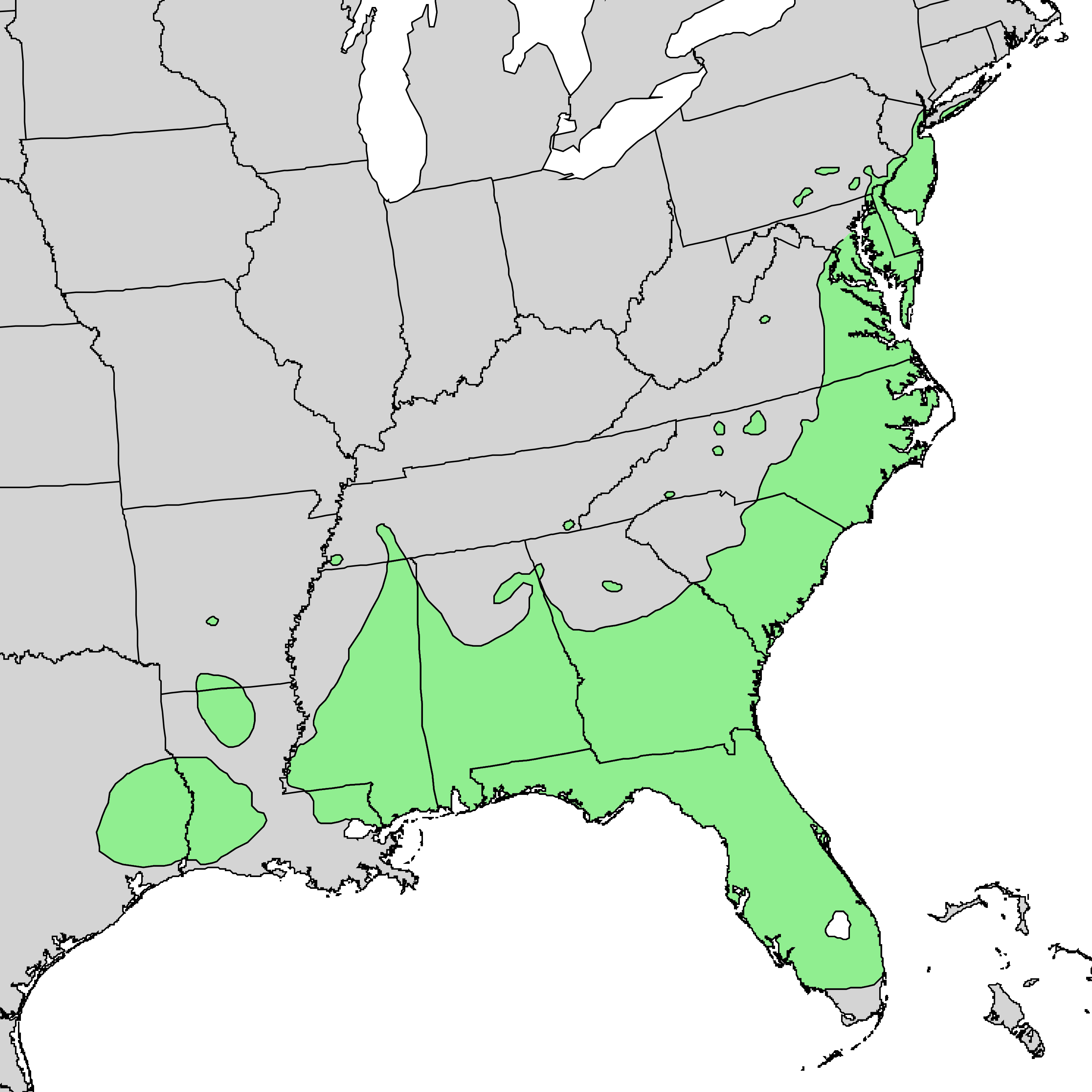
English: Range map of Magnolia virginica |
| Sanasi | |
| Manba | Digital representation of "Atlas of United States Trees" by Elbert L. Little, Jr. [1] |
| Muallif | U.S. Geological Survey |
Litsenziyalash
This image is in the public domain in the United States because it only contains materials that originally came from the United States Geological Survey, an agency of the United States Department of the Interior. For more information, see the official USGS copyright policy.
|
Original upload log
The original description page was here. All following user names refer to en.wikipedia.
- 2010-05-02 22:51 Masebrock 733×671× (124799 bytes) {{Information |Description=Range map of Magnolia virginica |Source=Digital representation of "Atlas of United States Trees" by Elbert L. Little, Jr. [http://esp.cr.usgs.gov/data/atlas/little/] |Date=1999 |Author=U.S. Geological Survey |Permission={{PD-USG
Fayl tarixi
Faylning biror paytdagi holatini koʻrish uchun tegishli sana/vaqtga bosingiz.
| Sana/Vaqt | Miniatura | Oʻlchamlari | Foydalanuvchi | Izoh | |
|---|---|---|---|---|---|
| joriy | 15:54, 3-Yanvar 2014 | | 2 977 × 2 977 (164 KB) | Nonenmac | higher resolution |
| 03:16, 10-Sentyabr 2011 |  | 1 200 × 1 200 (64 KB) | Nonenmac | Removed striping and changed to indexed color mode. | |
| 20:10, 7-Avgust 2010 |  | 733 × 671 (122 KB) | GreenZmiy | {{Information |Description={{en|Range map of Magnolia virginica}} |Source=Transferred from [http://en.wikipedia.org en.wikipedia]<br/> (Original text : ''Digital representation of "Atlas of United States Trees" by Elbert L. Little, Jr. [http://esp.cr.usgs |
Fayllarga ishoratlar
Bu faylga quyidagi sahifa bogʻlangan:
Faylning global foydalanilishi
Ushbu fayl quyidagi vikilarda ishlatilyapti:
- ab.wikipedia.org loyihasida foydalanilishi
- ar.wikipedia.org loyihasida foydalanilishi
- arz.wikipedia.org loyihasida foydalanilishi
- azb.wikipedia.org loyihasida foydalanilishi
- ca.wikipedia.org loyihasida foydalanilishi
- ceb.wikipedia.org loyihasida foydalanilishi
- cs.wikipedia.org loyihasida foydalanilishi
- en.wikipedia.org loyihasida foydalanilishi
- es.wikipedia.org loyihasida foydalanilishi
- fa.wikipedia.org loyihasida foydalanilishi
- koi.wikipedia.org loyihasida foydalanilishi
- la.wikipedia.org loyihasida foydalanilishi
- nl.wikipedia.org loyihasida foydalanilishi
- no.wikipedia.org loyihasida foydalanilishi
- pl.wikipedia.org loyihasida foydalanilishi
- pt.wikipedia.org loyihasida foydalanilishi
- ru.wikipedia.org loyihasida foydalanilishi
- sv.wikipedia.org loyihasida foydalanilishi
- th.wikipedia.org loyihasida foydalanilishi
- udm.wikipedia.org loyihasida foydalanilishi
- uk.wikipedia.org loyihasida foydalanilishi
- www.wikidata.org loyihasida foydalanilishi