
Fayl:Herat districts.png

Bu prevyuning hajmi: 786 × 600 piksel. Boshqa oʻlchamlari: 315 × 240 piksel | 629 × 480 piksel | 1 000 × 763 piksel.
Asl fayl (1 000 × 763 piksel, fayl hajmi: 34 KB, MIME tipi: image/png)

|
This map image could be re-created using vector graphics as an SVG file. This has several advantages; see Commons:Media for cleanup for more information. If an SVG form of this image is available, please upload it and afterwards replace this template with
{{vector version available|new image name}}.
It is recommended to name the SVG file “Herat districts.svg”—then the template Vector version available (or Vva) does not need the new image name parameter. |
Qisqa izoh
| Taʼrif |
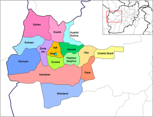
English: Map of the districts of Herat province of Afghanistan. Created by Rarelibra 19:24, 29 March 2007 (UTC) for public domain use, using MapInfo Professional v8.5 and various mapping resources. |
| Sanasi | 29 Mart 2007 (original upload date) |
| Manba | No machine-readable source provided. Own work assumed (based on copyright claims). |
| Muallif | No machine-readable author provided. Rarelibra assumed (based on copyright claims). |
Litsenziyalash
| I, the copyright holder of this work, release this work into the public domain. This applies worldwide. In some countries this may not be legally possible; if so: I grant anyone the right to use this work for any purpose, without any conditions, unless such conditions are required by law. |
Fayl tarixi
Faylning biror paytdagi holatini koʻrish uchun tegishli sana/vaqtga bosingiz.
| Sana/Vaqt | Miniatura | Oʻlchamlari | Foydalanuvchi | Izoh | |
|---|---|---|---|---|---|
| joriy | 14:52, 15-Fevral 2024 | | 1 000 × 763 (34 KB) | User-duck | Cropped 5 % horizontally, 6 % vertically using CropTool with lossless mode. |
| 19:24, 29-Mart 2007 |  | 1 056 × 816 (35 KB) | Rarelibra | Map of the districts of Herat province of Afghanistan. Created by ~~~~ for public domain use, using MapInfo Professional v8.5 and various mapping resources. |
Fayllarga ishoratlar
Bu faylga quyidagi 2 sahifalar bogʻlangan:
Faylning global foydalanilishi
Ushbu fayl quyidagi vikilarda ishlatilyapti:
- ar.wikipedia.org loyihasida foydalanilishi
- ast.wikipedia.org loyihasida foydalanilishi
- az.wikipedia.org loyihasida foydalanilishi
- bn.wikipedia.org loyihasida foydalanilishi
- ca.wikipedia.org loyihasida foydalanilishi
- de.wikipedia.org loyihasida foydalanilishi
- diq.wikipedia.org loyihasida foydalanilishi
- en.wikipedia.org loyihasida foydalanilishi
- eo.wikipedia.org loyihasida foydalanilishi
- es.wikipedia.org loyihasida foydalanilishi
- es.wikinews.org loyihasida foydalanilishi
- fa.wikipedia.org loyihasida foydalanilishi
- fa.wikivoyage.org loyihasida foydalanilishi
- fr.wikipedia.org loyihasida foydalanilishi
- he.wikipedia.org loyihasida foydalanilishi
- incubator.wikimedia.org loyihasida foydalanilishi
- it.wikipedia.org loyihasida foydalanilishi
- ka.wikipedia.org loyihasida foydalanilishi
- lt.wikipedia.org loyihasida foydalanilishi
- mn.wikipedia.org loyihasida foydalanilishi
- ms.wikipedia.org loyihasida foydalanilishi
- nl.wikipedia.org loyihasida foydalanilishi
- no.wikipedia.org loyihasida foydalanilishi
- pnb.wikipedia.org loyihasida foydalanilishi
- ps.wikipedia.org loyihasida foydalanilishi
- pt.wikipedia.org loyihasida foydalanilishi
- ro.wikipedia.org loyihasida foydalanilishi
- ru.wikipedia.org loyihasida foydalanilishi
- sd.wikipedia.org loyihasida foydalanilishi
- simple.wikipedia.org loyihasida foydalanilishi
- sk.wikipedia.org loyihasida foydalanilishi
- ta.wikipedia.org loyihasida foydalanilishi
Ushbu faylni koʻproq global foydalanishdan koʻring.