Fayl:Hammurabi's Babylonia 1.svg
Sahifa kontenti boshqa tillarda dastaklanmaydi.
Vikipediya, ochiq ensiklopediya

Asl fayl(SVG fayl, asl oʻlchamlari 655 × 570 piksel, fayl hajmi: 183 KB)

Ushbu fayl Vikiomborga yuklangan boʻlib, boshqa loyihalarda ham qoʻllanilishi mumkin. Uning tavsif sahifasidan olingan maʼlumot quyida keltirilgan.

 
W3C-validity not checked.

Qisqa izoh

Taʼrif

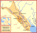
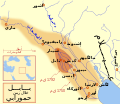
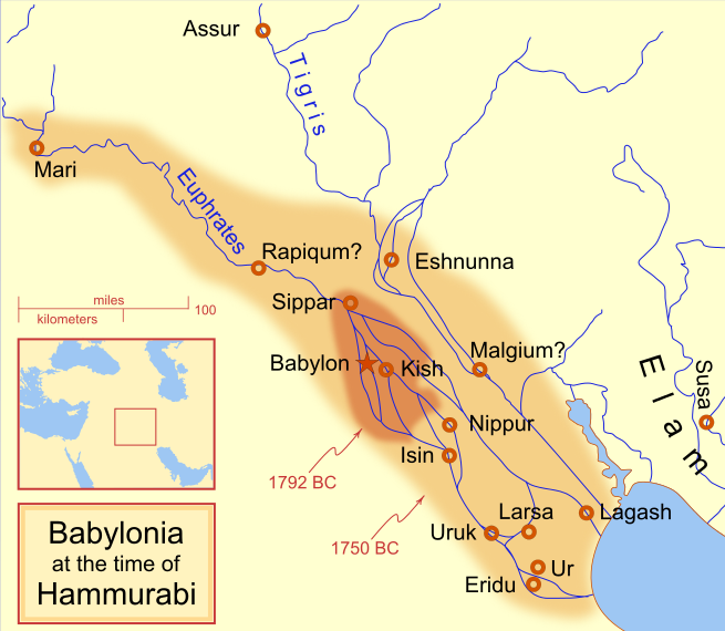
A locator map of Hammurabi's Babylonia, showing the Babylonian territory upon his ascension in 1792 BC and upon his death in 1750 BC. The river courses and coastline are those of that time period -- in general, they are not the modern rivers or coastlines. This is a Mercator projection, with north in its usual position

There is some question to what degree the cities of Nineveh, Tuttul, and Assur were under Babylonian authority. While in his introduction to his code of laws, Hammurabi claims lordship over these cities, Roaf does not include any of these in his map, upon which this map is based, and Chevalas states that "Assur and Nineveh were held for a very few years" (p. 155). Therefore, I have not included them as under Hammurabi's control in 1750 BC.
Sanasi
Manba Oʻzimning ishim
Muallif MapMaster
Other versions

[tahrirlash]

See also

References

  • Bjorklund, Oddvar; Holmboe, Haakon; Rohr, Anders (1970) Historical Atlas of the World, Barnes & Noble, NY, SBN: 389-00253-4.
  • Chavalas, Mark W.; K. Lawson Younger (2003) Mesopotamia and the Bible, Continuum International Publishing Group, ISBN 978-0567082312.
  • Hammond World Atlas Corporation (2007) Historical World Atlas, ISBN 9-780843-71391-6
  • Roaf, M. (1990) Cultural Atlas of Mesopotamia and the ancient Near East, Oxford: Facts on File. (In general, the basis for the ancient river courses and ancient coastline).
  • Van De Mieroop, Marc (2005). King Hammurabi of Babylon: A Biography. Blackwell Publishing. ISBN 1405126604

Litsenziyalash

I, the copyright holder of this work, hereby publish it under the following licenses:
GNU head Ushbu hujjatdan nusxa ko‘chirish, tarqatish va/yoki o‘zgartirish uchun GNU Erkin guvohnoma litsenziyasi (GNU Free Documentation License), 1.2 va har qanday keyingi versiyalar shartlariga muvofiq ruxsat berilgan yoki Ochiq kodli dasturlar jamiyati (Free Software Foundation) tomonidan chop etilgan; oʻzgarmas boʻlimlarsiz, oldingi muqova matnlari va orqa muqova matnlarisiz. Litsenziya nusxasi GNU Erkin guvohnoma litsenziyasi (GNU Free Documentation License) boʻlimiga kiritilgan.
w:en:Creative Commons
atribut bir xil ulashish
This file is licensed under the Creative Commons Attribution-Share Alike 4.0 International, 3.0 Unported, 2.5 Generic, 2.0 Generic and 1.0 Generic license.
Siz erkinsiz:
  • ulashishga – ishlanmani nusxalash, tarqatish va uzatish
  • remiks qilishga – ishni moslashtirishga
Quyidagi shartlar asosida:
  • atribut – Siz tegishli litsenziyaga havolani taqdim etishingiz va oʻzgartirishlar kiritilganligini koʻrsatishingiz kerak. Siz buni har qanday oqilona yoʻl bilan qilishingiz mumkin, lekin litsenziar Sizni yoki Sizning foydalanishingizni ma'qullashini taklif qiladigan tarzda emas.
  • bir xil ulashish – Agar Siz materialni remiks qilsangiz, oʻzgartirsangiz yoki unga asoslansangiz, oʻz hissalaringizni asl nusxadagi kabi bir xil yoki mos litsenziya ostida tarqatishingiz kerak.
Siz oʻzingiz xohlagan litsenziyani tanlashingiz mumkin.

Captions

Add a one-line explanation of what this file represents
Babylonian

Items portrayed in this file

tasvirlangan ob'ekt

18 Fevral 2008

image/svg+xml

Fayl tarixi

Faylning biror paytdagi holatini koʻrish uchun tegishli sana/vaqtga bosingiz.

(eng yangi | eng eski) Koʻrib chiqish (yangiroq 10 | ) (10 | 20 | 50 | 100 | 250 | 500)
Sana/VaqtMiniaturaOʻlchamlariFoydalanuvchiIzoh
joriy09:14, 21-Aprel 201309:14, 21-Aprel 2013 dagi versiya uchun tasvir655 × 570 (183 KB)CitypeekCleanup of file. Valid SVG now.
19:06, 27-Aprel 201019:06, 27-Aprel 2010 dagi versiya uchun tasvir655 × 570 (168 KB)DieBucheremoved border
15:05, 30-Iyul 200915:05, 30-Iyul 2009 dagi versiya uchun tasvir661 × 580 (317 KB)Amit6Some nodes changed.
23:24, 3-Mart 200823:24, 3-Mart 2008 dagi versiya uchun tasvir661 × 580 (163 KB)MapMasterAdded city-state, moved Sippar, minor other changes based on recent Kassite map
16:06, 23-Fevral 200816:06, 23-Fevral 2008 dagi versiya uchun tasvir661 × 580 (161 KB)MapMasterAdded 1 city, added name for 1 city
03:29, 21-Fevral 200803:29, 21-Fevral 2008 dagi versiya uchun tasvir661 × 580 (159 KB)MapMaster"blurred" the territory outlines
23:25, 20-Fevral 200823:25, 20-Fevral 2008 dagi versiya uchun tasvir661 × 580 (155 KB)MapMasterChanges made based on info from ''Mesopotamia and the Bible''
02:03, 19-Fevral 200802:03, 19-Fevral 2008 dagi versiya uchun tasvir663 × 580 (156 KB)MapMasterFixed an error on my part
21:12, 18-Fevral 200821:12, 18-Fevral 2008 dagi versiya uchun tasvir332 × 292 (156 KB)MapMastersome minor edits
19:19, 18-Fevral 200819:19, 18-Fevral 2008 dagi versiya uchun tasvir332 × 293 (154 KB)MapMasterremoved unrenderable bmp
(eng yangi | eng eski) Koʻrib chiqish (yangiroq 10 | ) (10 | 20 | 50 | 100 | 250 | 500)

Bu faylga quyidagi 2 sahifalar bogʻlangan:

Faylning global foydalanilishi

Ushbu fayl quyidagi vikilarda ishlatilyapti:

Ushbu faylni koʻproq global foydalanishdan koʻring.

Metama’lumot