
Fayl:GoldenHorde1300.png

Bu prevyuning hajmi: 800 × 481 piksel. Boshqa oʻlchamlari: 320 × 193 piksel | 640 × 385 piksel | 1 024 × 616 piksel | 1 436 × 864 piksel.
Asl fayl (1 436 × 864 piksel, fayl hajmi: 47 KB, MIME tipi: image/png)

|
This map image could be re-created using vector graphics as an SVG file. This has several advantages; see Commons:Media for cleanup for more information. If an SVG form of this image is available, please upload it and afterwards replace this template with
{{vector version available|new image name}}.
It is recommended to name the SVG file “GoldenHorde1300.svg”—then the template Vector version available (or Vva) does not need the new image name parameter. |
Qisqa izoh
| Taʼrif |
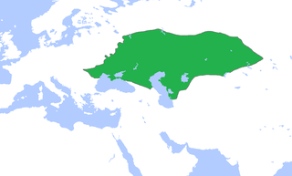
English: Locator map of the Golden Horde, c. 1300.
(Partially based on Atlas of World History (2007) - The World 1200-1300, map) |
| Sanasi | |
| Manba | Oʻzimning ishim |
| Muallif | Gabagool |
Litsenziyalash
I, the copyright holder of this work, hereby publish it under the following license:
This file is licensed under the Creative Commons Attribution 3.0 Unported license.
- Siz erkinsiz:
- ulashishga – ishlanmani nusxalash, tarqatish va uzatish
- remiks qilishga – ishni moslashtirishga
- Quyidagi shartlar asosida:
- atribut – Siz tegishli litsenziyaga havolani taqdim etishingiz va oʻzgartirishlar kiritilganligini koʻrsatishingiz kerak. Siz buni har qanday oqilona yoʻl bilan qilishingiz mumkin, lekin litsenziar Sizni yoki Sizning foydalanishingizni ma'qullashini taklif qiladigan tarzda emas.
Fayl tarixi
Faylning biror paytdagi holatini koʻrish uchun tegishli sana/vaqtga bosingiz.
| Sana/Vaqt | Miniatura | Oʻlchamlari | Foydalanuvchi | Izoh | |
|---|---|---|---|---|---|
| joriy | 15:58, 16-Noyabr 2022 | | 1 436 × 864 (47 KB) | Gyalu22 | Reverted to version as of 16:08, 5 June 2009 (UTC) |
| 16:12, 7-Iyun 2021 |  | 1 436 × 864 (28 KB) | Devlet Geray | Reverted to version as of 11:20, 4 June 2018 (UTC) they paid tribute to the Khan and because of this could trade but there were no independent states in Southern Crimea | |
| 12:04, 4-Iyun 2018 |  | 1 436 × 864 (28 KB) | Julieta39 | No Golden Horde control on the Southern Crimea (byzantine, later Theodoro principality) | |
| 11:20, 4-Iyun 2018 |  | 1 436 × 864 (28 KB) | Julieta39 | Shorelines, no modern dam lakes, Hungary and Galicia no ruled by Golden Horde | |
| 16:08, 5-Iyun 2009 |  | 1 436 × 864 (47 KB) | Gabagool | slightly cropped | |
| 13:00, 25-Aprel 2009 |  | 1 644 × 959 (56 KB) | Gabagool | {{Information |Description={{en|1=Locator map of the Golden Horde, c. 1300. (Partially based on ''Atlas of World History'' (2007) - The World 1200-1300, map)}} |Source=Own work by uploader |Author=Gabagool / Jarle Grøhn |Date=2009-04-2 |
Fayllarga ishoratlar
Bu faylga quyidagi sahifa bogʻlangan:
Faylning global foydalanilishi
Ushbu fayl quyidagi vikilarda ishlatilyapti:
- af.wikipedia.org loyihasida foydalanilishi
- ar.wikipedia.org loyihasida foydalanilishi
- arz.wikipedia.org loyihasida foydalanilishi
- ast.wikipedia.org loyihasida foydalanilishi
- azb.wikipedia.org loyihasida foydalanilishi
- az.wikipedia.org loyihasida foydalanilishi
- be.wikipedia.org loyihasida foydalanilishi
- bs.wikipedia.org loyihasida foydalanilishi
- ca.wikipedia.org loyihasida foydalanilishi
- cs.wikipedia.org loyihasida foydalanilishi
- cv.wikipedia.org loyihasida foydalanilishi
- cy.wikipedia.org loyihasida foydalanilishi
- da.wikipedia.org loyihasida foydalanilishi
- el.wikipedia.org loyihasida foydalanilishi
- en.wikipedia.org loyihasida foydalanilishi
- eo.wikipedia.org loyihasida foydalanilishi
- es.wikipedia.org loyihasida foydalanilishi
- et.wikipedia.org loyihasida foydalanilishi
- eu.wikipedia.org loyihasida foydalanilishi
- fa.wikipedia.org loyihasida foydalanilishi
- fr.wikipedia.org loyihasida foydalanilishi
- ga.wikipedia.org loyihasida foydalanilishi
- gl.wikipedia.org loyihasida foydalanilishi
- hi.wikipedia.org loyihasida foydalanilishi
- hr.wikipedia.org loyihasida foydalanilishi
- hu.wikipedia.org loyihasida foydalanilishi
- hy.wikipedia.org loyihasida foydalanilishi
- id.wikipedia.org loyihasida foydalanilishi
- incubator.wikimedia.org loyihasida foydalanilishi
Ushbu faylni koʻproq global foydalanishdan koʻring.