
Fayl:Europe subregion map UN geoscheme.svg

Size of this PNG preview of this SVG file: 680 × 520 piksel. Boshqa oʻlchamlari: 314 × 240 piksel | 628 × 480 piksel | 1 004 × 768 piksel | 1 280 × 979 piksel | 2 560 × 1 958 piksel.
Asl fayl (SVG fayl, asl oʻlchamlari 680 × 520 piksel, fayl hajmi: 228 KB)
Qisqa izoh
| Taʼrif |
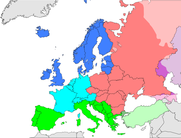
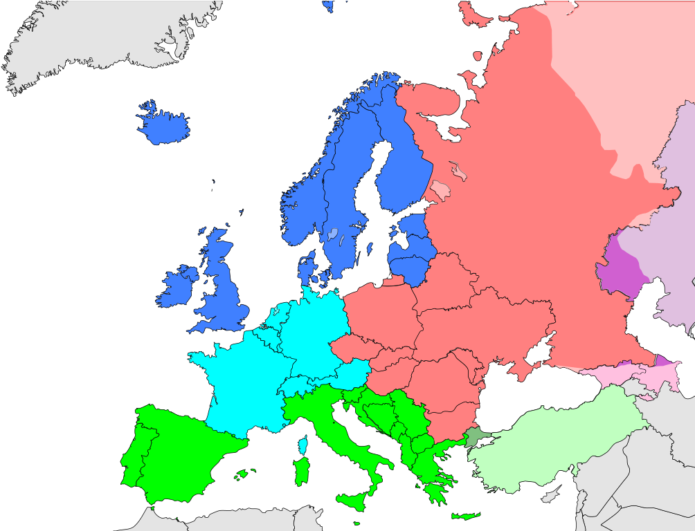
Deutsch: Subregionen Europas (nach UN Geoschema)
Nordeuropa
Westeuropa
Osteuropa
Südeuropa English: Subregions of Europe (UN geoscheme)
Northern Europe
Western Europe
Eastern Europe
Southern Europe
Countries of West Asia with partial territory in Southern Europe: Turkey
Countries of West Asia with partial territory in Eastern Europe: Georgia and Azerbaijan
Countries of Central Asia with partial territory in Eastern Europe: Kazakhstan
Русский: Макрорегионы Европы (классификация ООН)
Северная Европа
Западная Европа
Восточная Европа
Южная Европа
Страны макрорегиона Западная Азия с частичной территорией в Южной Европе: Турция
Страны макрорегиона Западная Азия с частичной территорией в Восточной Европе: Азербайджан и Грузия
Страны макрорегиона Центральная Азия с частичной территорией в Восточной Европе: Казахстан
Українська: Підрегіони Європи (класифікація Організації Об’єднаних Націй)
Північна Європа
Західна Європа
Східна Європа
Південна Європа |
| Sanasi | |
| Manba | Oʻzimning ishim |
| Muallif | Kolja21 |
| Other versions |
Derivative works of this file:
|


_de.png)
.png)


Litsenziyalash
I, the copyright holder of this work, hereby publish it under the following license:
This file is licensed under the Creative Commons Attribution 3.0 Unported license.
- Siz erkinsiz:
- ulashishga – ishlanmani nusxalash, tarqatish va uzatish
- remiks qilishga – ishni moslashtirishga
- Quyidagi shartlar asosida:
- atribut – Siz tegishli litsenziyaga havolani taqdim etishingiz va oʻzgartirishlar kiritilganligini koʻrsatishingiz kerak. Siz buni har qanday oqilona yoʻl bilan qilishingiz mumkin, lekin litsenziar Sizni yoki Sizning foydalanishingizni ma'qullashini taklif qiladigan tarzda emas.
Fayl tarixi
Faylning biror paytdagi holatini koʻrish uchun tegishli sana/vaqtga bosingiz.
| Sana/Vaqt | Miniatura | Oʻlchamlari | Foydalanuvchi | Izoh | |
|---|---|---|---|---|---|
| joriy | 13:50, 9-Noyabr 2021 | | 680 × 520 (228 KB) | TU-nor | Reverted to version as of 12:17, 22 February 2021 (UTC) No reason to color countries that are outside Europe in the Geosceme unless they are geographically transcontinental |
| 00:12, 6-Avgust 2021 |  | 680 × 520 (262 KB) | Vesperius | Cleanup at the edges. | |
| 23:53, 5-Avgust 2021 |  | 680 × 520 (238 KB) | Vesperius | Cyprus and Armenia included. | |
| 12:17, 22-Fevral 2021 |  | 680 × 520 (228 KB) | TU-nor | Andorra is Southern Europe in UN geoscheme | |
| 11:17, 23-Sentyabr 2015 |  | 680 × 520 (572 KB) | Alex Great | Reverted to version as of 09:22, 1 June 2014 | |
| 09:48, 10-Iyul 2015 |  | 744 × 1 052 (430 KB) | Andrej500 | Crimea | |
| 09:22, 1-Iyun 2014 |  | 680 × 520 (572 KB) | Insider | Russian Sochi Sector in Asia | |
| 18:50, 27-May 2009 |  | 680 × 520 (571 KB) | Kolja21 | {{Information |Description={{en|1=Subregions of Europe (UN geoschme)}} {{de|1=Subregionen Europas (nach UN Geoschema)}} |Source=Eigenes Werk (own work) |Author=Kolja21 |Date=2009-05-23 |Permission= |other_ |
Fayllarga ishoratlar
Bu faylga quyidagi 2 sahifalar bogʻlangan:
Faylning global foydalanilishi
Ushbu fayl quyidagi vikilarda ishlatilyapti:
- af.wikipedia.org loyihasida foydalanilishi
- am.wikipedia.org loyihasida foydalanilishi
- ar.wikipedia.org loyihasida foydalanilishi
- av.wikipedia.org loyihasida foydalanilishi
- awa.wikipedia.org loyihasida foydalanilishi
- azb.wikipedia.org loyihasida foydalanilishi
- ba.wikipedia.org loyihasida foydalanilishi
- be.wikipedia.org loyihasida foydalanilishi
- bn.wikipedia.org loyihasida foydalanilishi
- br.wikipedia.org loyihasida foydalanilishi
- ce.wikipedia.org loyihasida foydalanilishi
- cs.wikipedia.org loyihasida foydalanilishi
- cv.wikipedia.org loyihasida foydalanilishi
- cy.wikipedia.org loyihasida foydalanilishi
- de.wikipedia.org loyihasida foydalanilishi
- diq.wikipedia.org loyihasida foydalanilishi
- el.wikipedia.org loyihasida foydalanilishi
- en.wikipedia.org loyihasida foydalanilishi
Ushbu faylni koʻproq global foydalanishdan koʻring.