
Fayl:Cyprus 1973 ethnic neutral.svg

Size of this PNG preview of this SVG file: 800 × 570 piksel. Boshqa oʻlchamlari: 320 × 228 piksel | 640 × 456 piksel | 1 024 × 729 piksel | 1 280 × 912 piksel | 2 560 × 1 824 piksel | 1 088 × 775 piksel.
Asl fayl (SVG fayl, asl oʻlchamlari 1 088 × 775 piksel, fayl hajmi: 76 KB)
Qisqa izoh

This W3C-unspecified vector image was created with Inkscape .
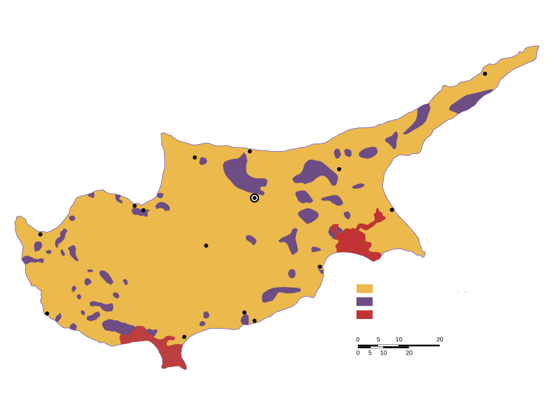
| Taʼrif | Ethnic distribution svg map of Cyprus in 1973, language neutral (check the source for town names and legend). |
| Sanasi | |
| Manba | Drawn by a map from the "Issues of the Middle East", CIA publication, at the Perry Castaneda colletion, Link: [1]. The yellow colour shows land with predominantly greek-cypriot population, while purple shows predominantly turkish-cypriot population (known in greece as "turkish-cypriot pockets"). British military bases are displayed in red colour. |
| Muallif | Badseed |
| Ruxsat (Bu faylning takror foydalanilishi) |
Public Domain |
| Other versions |
|


![[1]](http://www.lib.utexas.edu/maps/europe/cyprus_ethnic_1973.jpg)
Litsenziyalash
| I, the copyright holder of this work, release this work into the public domain. This applies worldwide. In some countries this may not be legally possible; if so: I grant anyone the right to use this work for any purpose, without any conditions, unless such conditions are required by law. |
Fayl tarixi
Faylning biror paytdagi holatini koʻrish uchun tegishli sana/vaqtga bosingiz.
| Sana/Vaqt | Miniatura | Oʻlchamlari | Foydalanuvchi | Izoh | |
|---|---|---|---|---|---|
| joriy | 20:31, 6-Fevral 2007 | | 1 088 × 775 (76 KB) | Badseed | {{Information |Description=Ethnic distribution map of Cyprus in 1973. Labels in Greek. |Source=Drawn by a map from the "Issues of the Middle East", CIA publication, at the Perry Castaneda colletion, Link: [http://www.lib.utexas.edu/maps/europe/cyprus_eth |
Fayllarga ishoratlar
Bu faylga quyidagi sahifa bogʻlangan:
Faylning global foydalanilishi
Ushbu fayl quyidagi vikilarda ishlatilyapti:
- am.wikipedia.org loyihasida foydalanilishi
- ar.wikipedia.org loyihasida foydalanilishi
- azb.wikipedia.org loyihasida foydalanilishi
- az.wikipedia.org loyihasida foydalanilishi
- be.wikipedia.org loyihasida foydalanilishi
- bg.wikipedia.org loyihasida foydalanilishi
- ca.wikipedia.org loyihasida foydalanilishi
- cs.wikipedia.org loyihasida foydalanilishi
- en.wikipedia.org loyihasida foydalanilishi
- eo.wikipedia.org loyihasida foydalanilishi
- es.wikipedia.org loyihasida foydalanilishi
- et.wikipedia.org loyihasida foydalanilishi
- eu.wikipedia.org loyihasida foydalanilishi
- fa.wikipedia.org loyihasida foydalanilishi
- fi.wikipedia.org loyihasida foydalanilishi
- gl.wikipedia.org loyihasida foydalanilishi
- hu.wikipedia.org loyihasida foydalanilishi
- id.wikipedia.org loyihasida foydalanilishi
- it.wikipedia.org loyihasida foydalanilishi
- ja.wikipedia.org loyihasida foydalanilishi
- ka.wikipedia.org loyihasida foydalanilishi
- nl.wikipedia.org loyihasida foydalanilishi
- no.wikipedia.org loyihasida foydalanilishi
- pnb.wikipedia.org loyihasida foydalanilishi
- pt.wikipedia.org loyihasida foydalanilishi
- ru.wikipedia.org loyihasida foydalanilishi
- sr.wikipedia.org loyihasida foydalanilishi
- sv.wikipedia.org loyihasida foydalanilishi
- th.wikipedia.org loyihasida foydalanilishi
- tr.wikipedia.org loyihasida foydalanilishi
- tt.wikipedia.org loyihasida foydalanilishi
- ur.wikipedia.org loyihasida foydalanilishi
- vi.wikipedia.org loyihasida foydalanilishi
- www.wikidata.org loyihasida foydalanilishi
- zh.wikipedia.org loyihasida foydalanilishi