
Fayl:British Empire 1921 IndianSubcontinent.png
Bu prevyuning hajmi: 800 × 351 piksel. Boshqa oʻlchamlari: 320 × 140 piksel | 640 × 281 piksel | 1 425 × 625 piksel.
Asl fayl (1 425 × 625 piksel, fayl hajmi: 39 KB, MIME tipi: image/png)
Qisqa izoh
| Taʼrif |
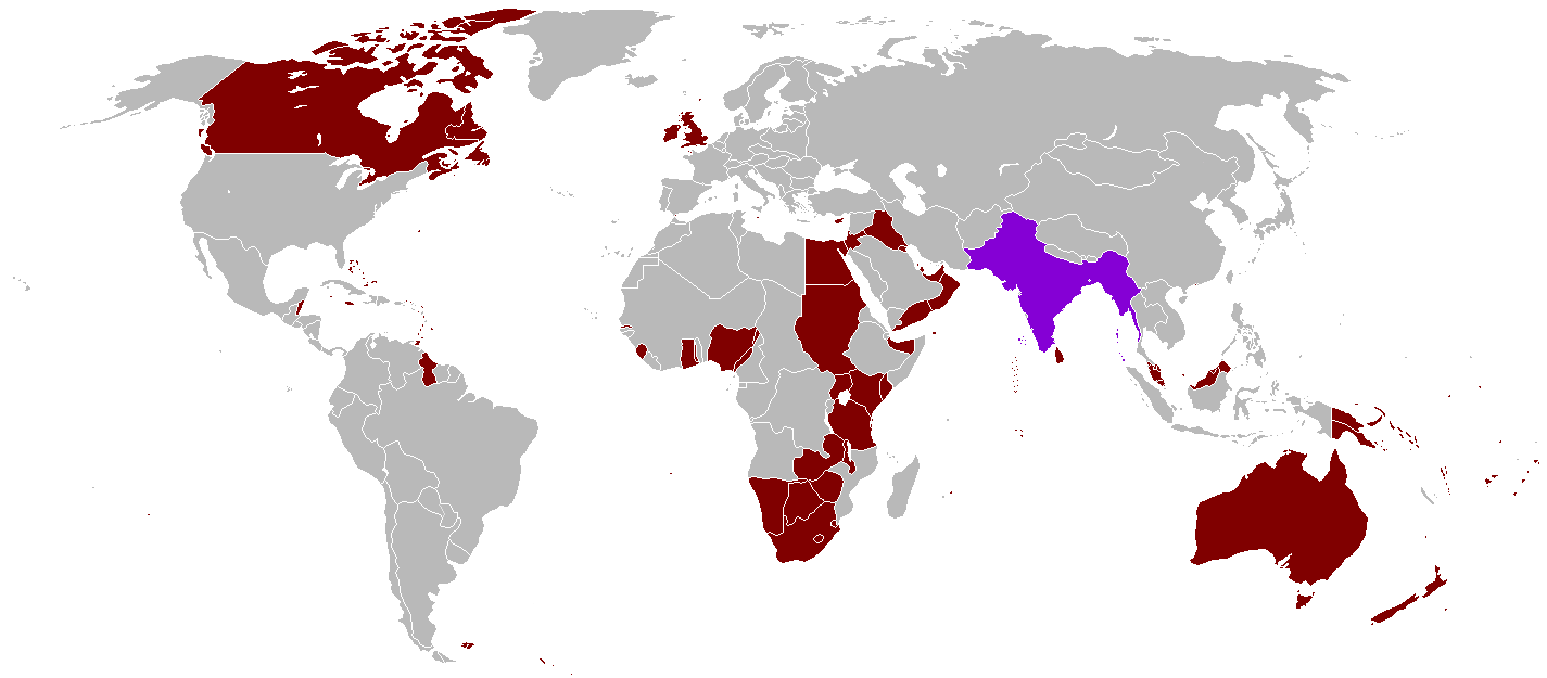
English: A map of the British Empire in 1921 when it was at its height with British India indicated when it too was at its height as well. |
||
| Sanasi | Uploaded on 27 Avgust 2008, 21:41. | ||
| Manba | Oʻzimning ishim | ||
| Muallif | Vadac. | ||
| Ruxsat (Bu faylning takror foydalanilishi) |
|
||
| Other versions | File:British Empire 1921.png, File:British and French empires 1920.png |

|
This historical map image could be re-created using vector graphics as an SVG file. This has several advantages; see Commons:Media for cleanup for more information. If an SVG form of this image is available, please upload it and afterwards replace this template with
{{vector version available|new image name}}.
It is recommended to name the SVG file “British Empire 1921 IndianSubcontinent.svg”—then the template Vector version available (or Vva) does not need the new image name parameter. |
Fayl tarixi
Faylning biror paytdagi holatini koʻrish uchun tegishli sana/vaqtga bosingiz.
| Sana/Vaqt | Miniatura | Oʻlchamlari | Foydalanuvchi | Izoh | |
|---|---|---|---|---|---|
| joriy | 07:59, 31-Oktyabr 2021 | | 1 425 × 625 (39 KB) | Randomastwritter | . |
| 22:25, 13-Avgust 2016 |  | 1 425 × 625 (39 KB) | RickoTroanman22 | Tibet re-added | |
| 18:58, 7-May 2011 |  | 1 425 × 625 (50 KB) | Quigley | Correct China's borders closer to what was internationally recognized at the time | |
| 01:42, 13-Oktyabr 2010 |  | 1 425 × 625 (50 KB) | Vadac | Aden was not part of the British Raj. Matched map to File:British Empire 1921.png | |
| 18:03, 11-Yanvar 2006 |  | 1 345 × 614 (28 KB) | Miljoshi | More Changes as per w:Talk:British Raj. | |
| 10:21, 9-Yanvar 2006 |  | 1 345 × 614 (28 KB) | Miljoshi | Correcting wrong inclusion of Nicaragua - w:User:Big Adamsky | |
| 11:51, 6-Yanvar 2006 |  | 1 345 × 614 (22 KB) | Miljoshi | Discounting Sri Lanka | |
| 10:30, 6-Yanvar 2006 |  | 1 345 × 614 (22 KB) | Miljoshi | Updated map with corrections in Aden, Lebanon, Nicaragua, New Caledonia, Goa, Daman, Pondycherri. | |
| 17:01, 5-Yanvar 2006 |  | 1 345 × 614 (23 KB) | Miljoshi | British Empire in 1921 - Indian subcontinent is highlighted in purple. Image based on GFDL Image:British Empire 1921.png by w:Arthur Wellesley |
Fayllarga ishoratlar
Bu faylga quyidagi sahifa bogʻlangan:
Faylning global foydalanilishi
Ushbu fayl quyidagi vikilarda ishlatilyapti:
- af.wikipedia.org loyihasida foydalanilishi
- bg.wikipedia.org loyihasida foydalanilishi
- da.wikipedia.org loyihasida foydalanilishi
- de.wikipedia.org loyihasida foydalanilishi
- en.wikipedia.org loyihasida foydalanilishi
- es.wikipedia.org loyihasida foydalanilishi
- hy.wikipedia.org loyihasida foydalanilishi
- id.wikipedia.org loyihasida foydalanilishi
- kk.wikipedia.org loyihasida foydalanilishi
- kn.wikipedia.org loyihasida foydalanilishi
- ml.wikipedia.org loyihasida foydalanilishi
- nl.wikipedia.org loyihasida foydalanilishi
- nn.wikipedia.org loyihasida foydalanilishi
- no.wikipedia.org loyihasida foydalanilishi
- ru.wikipedia.org loyihasida foydalanilishi
- tum.wikipedia.org loyihasida foydalanilishi
- vep.wikipedia.org loyihasida foydalanilishi