
Fayl:1753 Vaugondy Map of Persia, Arabia and Turkey - Geographicus - TurkeyArabiaPersia-vaugondy-1753.jpg
Bu prevyuning hajmi: 698 × 599 piksel. Boshqa oʻlchamlari: 280 × 240 piksel | 559 × 480 piksel | 895 × 768 piksel | 1 193 × 1 024 piksel | 2 385 × 2 048 piksel | 5 000 × 4 293 piksel.
Asl fayl (5 000 × 4 293 piksel, fayl hajmi: 6,9 MB, MIME tipi: image/jpeg)
| Etats du Grand-Seigneur en Asie, Empire de Perse, Pays des Usbecs, Arabie et Egypte. | ||||||
|---|---|---|---|---|---|---|
| Artist | ||||||
| Title |
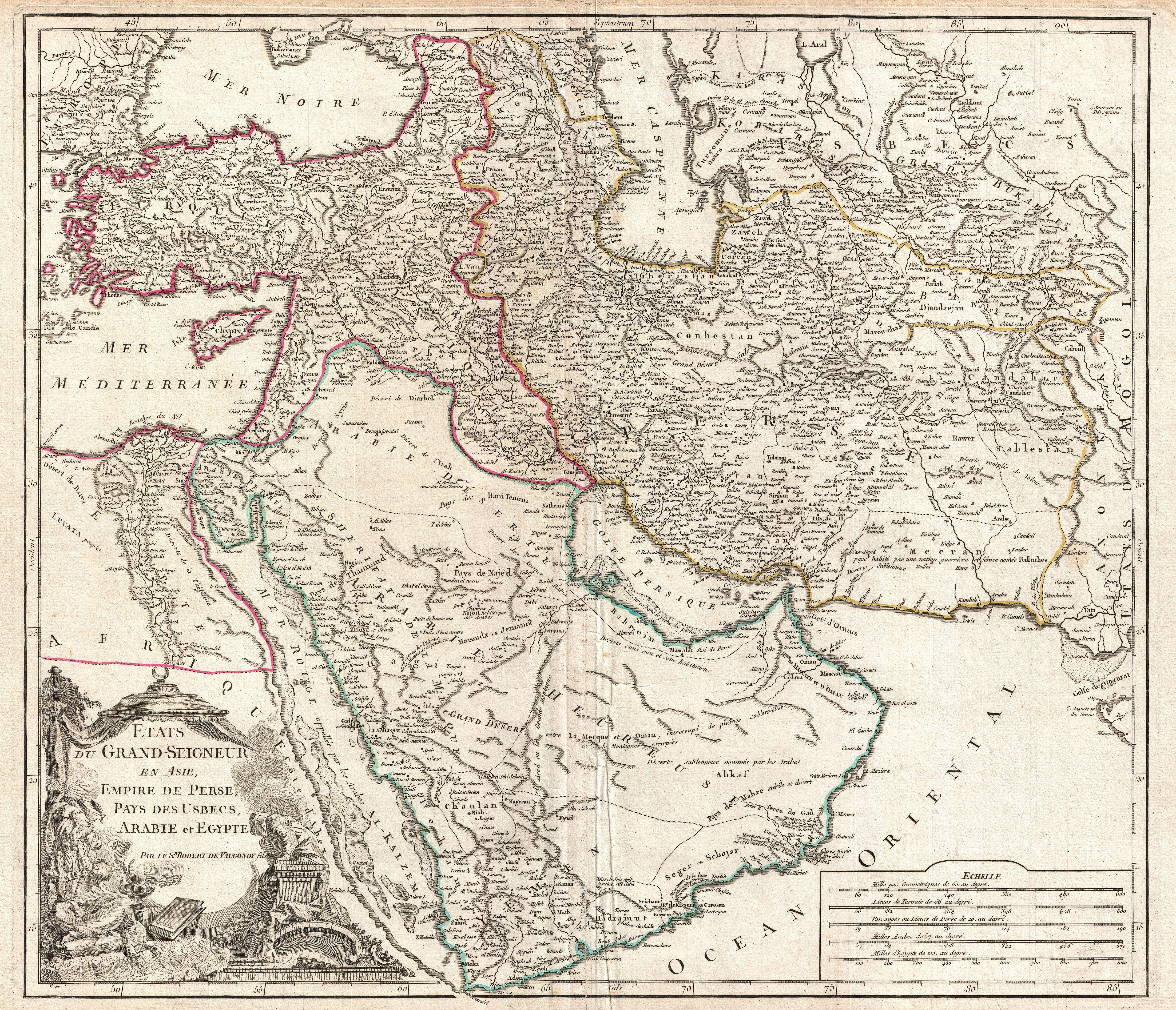
Etats du Grand-Seigneur en Asie, Empire de Perse, Pays des Usbecs, Arabie et Egypte. |
|||||
| Taʼrif |
English: This is Robert de Vaugondy’s spectacular 1753 map of the Ottoman Empire. Vaugondy maps the empire at its height, with territory spanning from the Black Sea to the southernmost extension of Arabia and west, inclusive of Persia, as far as the Mongol Empire of India. Includes the modern day nations of Turkey, Egypt, Saudi Arabia, Oman, Yemen, the United Arab Emirates, Iran, Iraq, Kuwait, Israel, Palestine, Jordan, Syria, Lebanon, Armenia, Azerbaijan, Georgia, and parts of Afghanistan, Pakistan, India, Uzbekistan, and Greece. Vaugondy employs all of the latest geographical information of the time incorporating both French and transliterations Arabic place names. This map offers splendid detail throughout inclusive of undersea shoals and reefs in the Red Sea and Persian Gulf, mountain ranges, lakes, rivers, and historical sites. A highly decorative title cartouche showing an Ottoman prince appears in the lower left quadrant. Five distance scales are in the lower right. Drawn by Robert de Vaugondy in 1753 and published in the 1757 issue of his Atlas Universal . |
|||||
| Sanasi | 1753 (undated) | |||||
| Dimensions | balandligi/bo'yi: 19,5 in (49,5 cm); width: 22 in (55,8 cm) | |||||
| Accession number |
Geographicus link: TurkeyArabiaPersia-vaugondy-1753 |
|||||
| Source/Photographer |
Vaugondy, R., Atlas Universel, (Paris) 1784.
|
|||||
| Ruxsat (Bu faylning takror foydalanilishi) |
|
|||||
Fayl tarixi
Faylning biror paytdagi holatini koʻrish uchun tegishli sana/vaqtga bosingiz.
| Sana/Vaqt | Miniatura | Oʻlchamlari | Foydalanuvchi | Izoh | |
|---|---|---|---|---|---|
| joriy | 03:03, 25-Mart 2011 | | 5 000 × 4 293 (6,9 MB) | BotMultichillT | {{subst:User:Multichill/Geographicus |link=http://www.geographicus.com/P/AntiqueMap/TurkeyArabiaPersia-vaugondy-1753 |product_name=1753 Vaugondy Map of Persia, Arabia and Turkey |map_title=Etats du Grand-Seigneur en Asie, Empire de Perse, Pays des Usbecs, |
Fayllarga ishoratlar
Bu faylga quyidagi sahifa bogʻlangan:
Faylning global foydalanilishi
Ushbu fayl quyidagi vikilarda ishlatilyapti:
- azb.wikipedia.org loyihasida foydalanilishi
- ba.wikipedia.org loyihasida foydalanilishi
- bs.wikipedia.org loyihasida foydalanilishi
- en.wikipedia.org loyihasida foydalanilishi
- hr.wikipedia.org loyihasida foydalanilishi
- hu.wikipedia.org loyihasida foydalanilishi
- ru.wikipedia.org loyihasida foydalanilishi
- sh.wikipedia.org loyihasida foydalanilishi